- Oklahoma State Highway 58
-
State Highway 58
Route information Maintained by ODOT Existed: 1930 or 1931 – present Section 1 Length: 73 mi (117 km) South end:  SH-49 in Medicine Park
North end: Blaine–Custer county line Section 2 Length: 106 mi (171 km) South end: 


 US-270/281/SH-3/33 west of Watonga
North end: Kansas state line Highway system Oklahoma State Highways
Oklahoma turnpike system←  SH-56
SH-56US-59  →
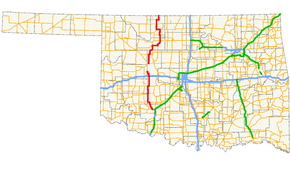
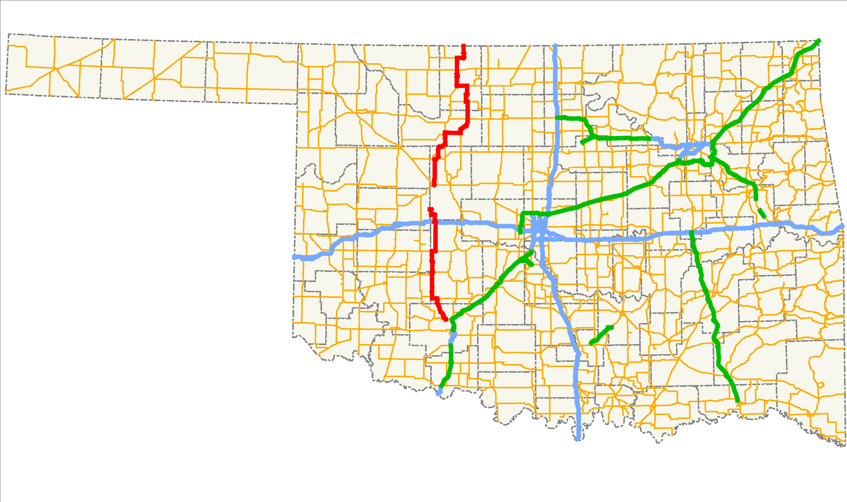
→State Highway 58 (abbreviated SH-58 or OK-58) is the name of two state highways in Oklahoma. One of them runs for 73 miles (117.5 km) from Medicine Park to the Blaine–Custer County line near Hydro,[1] and the other connects US-270/281/SH-3/33 to the Kansas state line, running 106 mi (171 km).[2] The northern section has one lettered spur route, SH-58A.
SH-58 was originally a part of US-164. When US-164 was decommissioned in 1930, a section of the road in Major County that was left without a designation became SH-58. Since then, the highway has grown toward both the north and the south. With the designation and extension of the southern section of the highway, SH-58 is present in five counties in the western part of the state.
Contents
Route description
Southern section
The southern SH-58 begins at an intersection with State Highway 49 in Medicine Park in Comanche County. It heads north, passing Lake Lawtonka before meeting State Highway 19, which it overlaps for four miles (6.4 km).[3] After splitting off, it meets State Highway 9 in Carnegie. It passes through the unincorporated community of Alfalfa, after which it has a two-mile (3.2 km) concurrency with State Highway 152.[3]
After splitting from SH-152 near Eakly, SH-58 heads north to an interchange with Interstate 40, then passes through Hydro. Nine miles (14.5 km)[3] later, it terminates at the Custer County line to become a county road, which eventually connects to State Highway 54.[1]
Northern section
The northern SH-58 begins at US-270/281/SH-3/33 west of Watonga. It meets State Highway 51 near Canton and continues north through Longdale. In Fairview, the county seat of Major County, it shares a brief concurrency with U.S. Highway 60. Beginning in Fairview and heading east, SH-58 has a concurrency with State Highway 8, with which it switches places (south of the concurrency SH-8 runs to the east of SH-58, and north of it, SH-8 runs to the west of SH-58).
SH-58 continues north, meeting US-60 again near Ringwood. It then has a brief concurrency with State Highway 45 near Helena. Near Jet, it overlaps U.S. Highway 64 and SH-8. North of Cherokee, the Alfalfa County seat, US-64 splits off and State Highway 11 joins the three-route concurrency. North of Driftwood, SH-58 splits off on its own and passes through Byron and Amorita.[3] It terminates at the Kansas state line, where it becomes a low-grade county road, from which commercial traffic is banned.[2]
History
SH-58 was first commissioned some time between March 1, 1930 and December 1, 1931. The original extent of the route was much shorter than the present highway. In 1931, SH-58 was a dirt road extending from SH-8 east of Fairview north to Ringwood.[4] Prior to receiving the SH-58 designation, this section of road was part of US-164 and the first SH-13.[5] In 1930, US-164 was decommissioned due to an extension of US-60.[6] When US-60 replaced US-164 through the area, it was changed to the more westerly route it takes in the present day. The section of old U.S. highway that no longer had a designation became SH-58.[4]
Throughout the 1930s, SH-58 was expanded in both directions. The first addition to the highway came during the first half of 1932, when the highway was extended north to Helena. No east–west highway existed at this point yet, leading to a spur end.[7] The highway was extended to the south, replacing SH-44, to Canton on March 29, 1937.[8][9] SH-58 was extended north to the Kansas state line sometime between April 1937 and April 1938.[10] This final extension brought SH-58's northern section to its present-day termini, and no major changes to the northern section have occurred since.
SH-58's southern section was first established on October 16, 1945, when SH-54 was given a new alignment further to the west; its old alignment was redesignated as SH-58.[11] The original routing of SH-58's southern section began at US-277 in Cyril, continued west through Apache, and turned north at the present-day western intersection of with SH-19. SH-58 continued north along its present alignment to Hydro, where it ended at US-66/SH-1.[12]
In 1955, SH-19 was established through southern Caddo County, taking over the east–west section of SH-58. Thus, SH-58 was truncated to where it intersected with SH-19 (the present day western end of their concurrency).[13] SH-58 was extended to its present terminus north of Hydro the next year.[14] The highway was further extended in 1964, bringing the southern terminus to its present location near Medicine Park.[15] No further routing changes have occurred since then.[3]
SH-58A

SH-58 has one spur, SH-58A, a 5.33-mile (8.58 km)[16] route in Blaine County. The route begins at SH-58 near Longdale, and travels to Canton Lake. There, the highway runs across the dam impounding the lake. The highway then turns south and ends at SH-51 west of Canton.[3]
Junction list
Southern section
County Location Mile[1] Destinations Notes Comanche Medicine Park 0.0 SH-49Southern section's southern terminus Caddo 13.6  SH-19
SH-19Eastern end of SH-19 concurrency 17.5 SH-19Western end of SH-19 concurrency Carnegie 30.5  SH-9
SH-943.8  SH-152
Western end of SH-152 concurrency 45.6 SH-152Eastern end of SH-152 concurrency Hydro 63.0  I-40
I-40Interchange Blaine No major junctions Blaine–Custer county line 73.0 Southern section's northern terminus 1.000 mi = 1.609 km; 1.000 km = 0.621 mi
Concurrency terminus • Closed/Former • Incomplete access • UnopenedNorthern section
County Location Mile[1] Destinations Notes Blaine 0.0 US-270/281/SH-3/33Northern section's southern terminus Canton 14.8  SH-51
SH-51Western end of SH-51 concurrency 15.8 SH-51Eastern end of SH-51 concurrency 19.3  SH-58A
Northern terminus of SH-58A Major 27.1  SH-51A
Northern terminus of SH-51A 32.9  US-60
US-60Southern end of US-60 concurrency Fairview 33.9  US-60/SH-8
Northern end of US-60 concurrency, western end of SH-8 concurrency 42.8 SH-8Eastern end of SH-8 concurrency Ringwood 52.7  US-60/US-412
Alfalfa 62.7  SH-45
SH-45Eastern end of SH-45 concurrency Helena 63.7 SH-45Western end of SH-45 concurrency 73.2  US-64
US-64Eastern end of US-64 concurrency 79.1 SH-8Southern end of SH-8 concurrency Ingersoll 88.3  US-64/SH-11
Western end of US-64 concurrency, southern end of SH-11 concurrency Driftwood 95.3 SH-8/11Northern end of SH-8/SH-11 concurrency 106.0 S.W. 140 Ave. (Harper County road) Kansas state line; northern terminus of northern section 1.000 mi = 1.609 km; 1.000 km = 0.621 mi
Concurrency terminus • Closed/Former • Incomplete access • UnopenedReferences
- ^ a b c d Stuve, Eric. "OK-58s". OKHighways. http://www.okhighways.com/ok58s.html. Retrieved 2006-01-12.
- ^ a b Stuve, Eric. "OK-58n". OKHighways. http://www.okhighways.com/ok58n.html. Retrieved 2006-01-12.
- ^ a b c d e f Oklahoma Department of Transportation. Official State Map (Map) (2008 ed.).
- ^ a b Oklahoma Department of Highways. Map Showing Condition of Improvement of the State Highway System (Map) (December 1, 1931 ed.). http://www.odot.org/hqdiv/p-r-div/maps/state-maps/pdfs/1931.pdf. Retrieved 2008-04-16.
- ^ Oklahoma Department of Highways. Map Showing Condition of Improvement of the State Highway System (Map) (March 1, 1930 ed.). http://www.odot.org/hqdiv/p-r-div/maps/state-maps/pdfs/1930.pdf. Retrieved 2008-04-16.
- ^ Droz, Robert V. "The Big Table". U.S. Highways : From US-1 to (US-830). http://www.us-highways.com/usbt.htm. Retrieved 2008-04-16.
- ^ Oklahoma Department of Highways. Map Showing Condition of Improvement of the State Highway System (Map) (June 1932 ed.). http://www.odot.org/hqdiv/p-r-div/maps/state-maps/pdfs/1932.pdf. Retrieved 2008-04-16.
- ^ Oklahoma Department of Transportation. "Memorial Dedication and Revision History, SH 44". http://www.okladot.state.ok.us/memorial/legal/sh44.htm. Retrieved 2010-04-07.
- ^ Oklahoma Department of Highways. Map Showing Condition of Improvement of the State Highway System (Map) (April 1937 ed.). http://www.odot.org/hqdiv/p-r-div/maps/state-maps/pdfs/1937.pdf. Retrieved 2008-04-16.
- ^ Oklahoma Department of Highways. Map Showing Condition of Improvement of the State Highway System (Map) (April 1938 ed.). http://www.odot.org/hqdiv/p-r-div/maps/state-maps/pdfs/1938.pdf. Retrieved 2008-04-16.
- ^ Oklahoma Department of Transportation, Planning & Research Division. "Chronological History of State Highway 54". http://www.okladot.state.ok.us/memorial/legal/sh54.pdf. Retrieved 2008-04-16.
- ^ Oklahoma Department of Highways. State road map (Map) (1947 ed.). http://www.odot.org/hqdiv/p-r-div/maps/state-maps/pdfs/1947.pdf. Retrieved 2008-11-02.
- ^ Oklahoma Department of Highways. Oklahoma's Highways 1956 (Map). http://www.odot.org/hqdiv/p-r-div/maps/state-maps/pdfs/1956.pdf. Retrieved 2008-04-16.
- ^ Oklahoma Department of Highways. Oklahoma's Highways 1957 (Map). http://www.odot.org/hqdiv/p-r-div/maps/state-maps/pdfs/1957.pdf. Retrieved 2008-04-16.
- ^ Oklahoma Department of Highways. Oklahoma 1965 (Map). http://www.odot.org/hqdiv/p-r-div/maps/state-maps/pdfs/1965.pdf. Retrieved 2008-04-16.
- ^ Oklahoma Department of Transportation. 2008 Control Section Maps (Map). p. Blaine 6. http://www.odot.org/hqdiv/p-r-div/maps/control-maps/blaine.pdf. Retrieved 2008-11-01.
External links
Categories:- State highways in Oklahoma


Wikimedia Foundation. 2010.