- Oklahoma State Highway 33
-
State Highway 33
Route information Maintained by ODOT Length: 234.4 mi (377.2 km) Major junctions West end:  TX-33 at the Texas state line
East end: 
 SH-66/SH-75A/SH-97 in Sapulpa
Highway system Oklahoma State Highways
Oklahoma turnpike system←  SH-32
SH-32SH-34  →
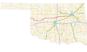
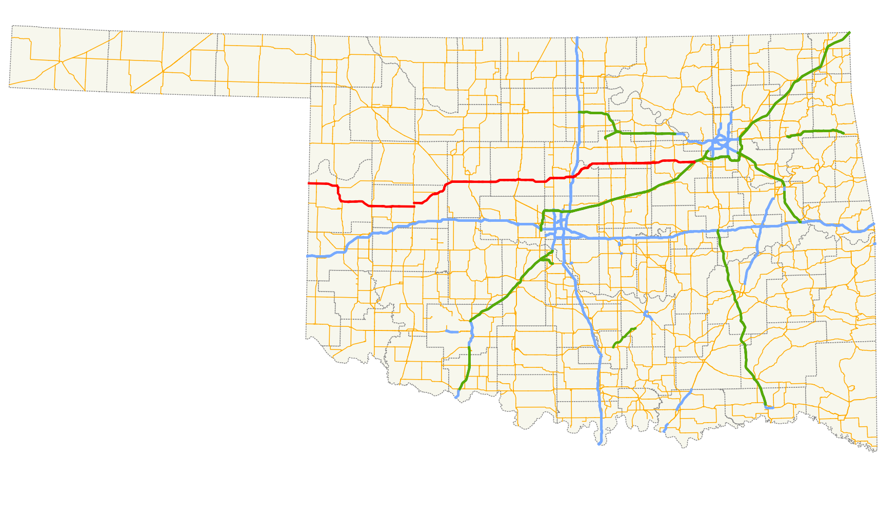
→Oklahoma's State Highway 33 (abbreviated SH-33 or OK-33) is a major highway that traverses most of the state, and at one time traversed the entire state. Its general orientation is west to east. All mileages listed herein are from the western terminus of the highway at the Texas state line.
Contents
Route description
Roger Mills County
SH-33 begins at the Hemphill, Tex./Roger Mills, Okla. county line. At milestone 4.2, SH-30 intersects leading to Erick. The highway runs alongside the Black Kettle National Grassland to its intersection with US-283 at milestone 15.7. SH-33 overlaps US-283 to mile 16.9, where it begins a three-route concurrency with SH-47, which leads east to Putnam. Along the three-route concurrency, the highway passes through the National Grassland, and at milestone 24.8 SH-33 swings off to the left while US-283 and SH-47 continues toward Cheyenne. At mile 29.5, SH-33 passes Strong City, and at mile 42.7 passes the town of Hammon with its intersection with SH-34.
Custer County
The intersection with SH-34 marks the county line. Mile 53.6 marks Butler, and at 53.8 SH-44 runs out, which leads south to Foss Lake, the town of Foss, and later Altus. At mile 66.2 SH-33 comes to US-183, which leads south to Clinton. SH-33 continues north concurrent with US-183 two miles (3 km) to mile 68.2, where US-183 continues northward to Taloga and SH-33 turns east once again. At mile 72.6, the highway intersects Custer City's Main Street before turning to the left. At mile 81.7 SH-33 enters Thomas at its second intersection with SH-47. At 83.8, SH-54 ends, which leads to Weatherford. At 87.0, SH-33 crosses the South Canadian River, and at mile 90.1 SH-33 enters Dewey County.
Dewey County
As SH-33 enters Dewey County, the section line road on the county line can be followed a few hundred yards west to the unincorporated settlement of Fay. After a mere 1.5 miles (2.4 km) in Dewey County, SH-33 enters Blaine County at milestone 91.6.
Blaine County
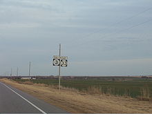 SH-3 and SH-33 concurrency in eastern Blaine County.
At mile 94.2, SH-33 reaches an intersection involving five state highways. If the driver continues straight at this intersection, he will be on SH-58, which leads to Canton Lake. A left turn will follow the three-route concurrency of SH-3, US-270, and US-281, which is the so-called Governor George Nigh Northwest Passage to Woodward and the panhandle. This corridor is at least three lanes (one lane each direction with an alternating passing lane) all the way through the panhandle into Colorado. A right turn at the intersection, which is the natural movement from the driver's point of view, will be the east/southeast direction of the aforementioned three-route concurrency, which becomes a four-route concurrency with SH-33. The highway becomes four full lanes at this point. At mile 101.3 the US-270/US-281/SH-3/SH-33 concurrency crosses the North Canadian River. At mile 103.8 the driver has entered Watonga and has reached the intersection with SH-8. Going north on SH-8 will lead to Roman Nose State Park. The south leg of the intersection, where US-270 and US-281 diverge, leads to Hinton and Red Rock Canyon State Park, and provides an alternate route into Oklahoma City. Upon leaving Watonga, the remaining concurrency (SH-3/SH-33) reduce to the three-lane arrangement mentioned above, and continue eastward to mile 115.7, the Kingfisher County line.
Kingfisher County
Once SH-3/SH-33 have entered Kingfisher County, the road reduces to the conventional two lanes. At mile 131.5, the concurrency intersects US-81 in downtown Kingfisher. US-81 northbound goes to Enid and Wichita, whereas SH-3 diverges south onto US-81 southbound, which leads to Okarche, where the two highways split to reach Okla. City and El Reno respectively. This general vicinity is also the location of the crossing of the Chisholm Trail. At mile 146.3, SH-33 intersects SH-74F, which straddles the Logan County line south to Cashion.
Logan County
SH-33's path through Logan County mostly parallels the Cimarron River. At mile 152.0, SH-74 intersects SH-33 with a four-way stop. Northbound SH-74 leads to Crescent, and southbound SH-74 eventually becomes the Lake Hefner Parkway in Oklahoma City. For the next few miles, SH-33 passes through the Cedar Valley golf course complex, and at mile 161.2 intersects US-77 in downtown Guthrie, Oklahoma's first capital. Near the east end of Guthrie, SH-33 once again becomes a four-lane highway before intersecting I-35 at mile 162.9. At mile 163.1, SH-105 to Tryon cuts off to the right as SH-33 turns to the left. The historic SH-33 turns off to the right at mile 169.2, although the old alignment is not marked other than a sign pointing to the town of Langston. At mile 172.4 the driver may diverge from the highway to visit historic Langston University, before the new alignment merges with the old alignment at mile 173.3. At this point, the highway narrows to two lanes. The old alignment quickly diverges into the town at Coyle at mile 173.6, and the current roadway crosses the Cimarron River at mile 174.6.
Payne County
The Cimarron River forms the county line, where the scar from an old steel truss bridge is visible just east of the highway. Shortly into Payne County, the highway rejoins the old alignment at mile 175.5. At mile 185.1, US-177 goes north to Stillwater and overlaps SH-33 eastbound for one mile (1.6 km). At 186.1, US-177 diverges south into Perkins and toward Shawnee. As SH-33 continues east through Payne County, it crosses the Cimarron River again at mile 193.1 before intersecting SH-108, which goes north to Ripley, at 193.5. At mile 195.3, SH-18 comes in from the south, and overlaps SH-33 into Cushing, the "Pipeline Capital of the World." At mile 201.6, SH-18 diverges north toward Pawnee. Upon exiting Cushing, SH-33 becomes a four-lane road forging eastward, and at mile 208.1 converges with SH-99, whose south leg leads to Ada. The SH-33/SH-99 concurrency continues east into Creek County.
Creek County
Mile 209.8 is the county line, and shortly thereafter at mile 210.2, SH-33 Bypass provides a route for trucks to circumnavigate Drumright to the north and west. At mile 211.9, on the east side of Drumright, SH-99 diverges to the north toward Pawhuska, and SH-16 travels south toward Muskogee. SH-48 intersects SH-33 at mile 223.1, which goes south to Bristow and north to Cleveland. At mile 234.2 SH-33 intersects I-44, which in this location is the Turner Turnpike, a toll road to Oklahoma City and Tulsa. Shortly thereafter, SH-33 runs out after a tenure of 234.4 miles (377.2 km) at SH-66, at the intersection of Main St and Mission St in central Sapulpa.
History
In addition to the current alignment presented above, SH-33 extended at one time all the way to Arkansas. However, the advent of the ever-expanding US-412 in Oklahoma would have meant unnecessary concurrencies beyond its current terminus.
From the intersection of SH-66, SH-33 overlapped the then-US-66 through Sapulpa onto New Sapulpa Road, eventually merging into I-44 in west Tulsa. The three-route concurrency followed the present alignment of I-44 through Tulsa to Dysfunction Junction, where SH-66 currently diverges into Catoosa. I-44 now continues another mile and a half or so to the Creek Turnpike, where the terminus of the Will Rogers Turnpike to Joplin, Missouri has been relocated. The old SH-33 followed the current US-412 to the junction of US-69, then north along US-69 a couple of miles, then back east, merging onto the current US-412 before crossing the Grand River. SH-33 followed the current Scenic US-412, whereas the Cherokee Turnpike parallels this narrow and winding road to the Flint Creek Valley. The historic SH-33 then followed the current alignment of US-412 to the Arkansas State Line, where it became AR-68 in Siloam Springs.
Spurs and loops
- Truck SH-33 (2.3 mi/3.7 km) bypasses Drumright to the north and west, connecting with SH-99 at the eastern terminus.
- SH-33C (decommissioned; 3.0 mi/4.8 km) is now SH-412A. Leads to Oaks in Delaware County.
- SH-33G (decommissioned; 5.3 mi/8.5 km) is now SH-412B. Goes through the Mid-America Industrial Park and ties in with SH-69A northeast of Chouteau.
- SH-33P (decommissioned; 1.2 mi/2.0 km) is now SH-412P. Goes south from US-412 along NS414 Rd. to EW60 (Admiral Pl.), then along EW60 to the Verdigris River.
Junction list
County Location Mile[1] Destinations Notes Roger Mills 0.0 TX-33Western terminus 4.2  SH-33
SH-3315.8  US-283
Roll 17.0  SH-47
SH-4725.0 US-283/SH-47Hammon 42.9 SH-34Custer Butler 53.9  SH-44
SH-44Northern terminus of SH-44 66.4  US-183
68.3 US-183Thomas 81.7 SH-4783.9  SH-54
SH-54Northern terminus of SH-54 Dewey No junctions Blaine 94.3 


 US-270/281/SH-3/58
Southern terminus of SH-58 Watonga 103.9  US-270/281/SH-8
SH-8 does not run concurrent with SH-33 Kingfisher Kingfisher 131.5  US-81/SH-3
US-81 does not run concurrent Logan 146.4  SH-74F
Northern terminus of SH-74F Cedar Valley 152.1  SH-74
SH-74Guthrie 161.2  US-77
US-77<0.1 mi concurrency 162.9  I-35
I-35Diamond interchange 163.1  SH-105
Western terminus SH-105 Payne 185.9  US-177
Perkins 186.8 US-177194.0  SH-108
Southern terminus of SH-108 194.0  SH-18
SH-18Cushing 202.0 SH-18208.7  SH-99
SH-99Creek Drumright 212.4  SH-16/99
SH-16 does not run concurrent with SH-33 223.6  SH-48
SH-48Bristow 234.8  I-44/Turner Tpk
235.1 SH-66SH-66 concurs through the end of SH-33 Sapulpa 237.8  SH-117
239.7  SH-66/97/75A
Eastern terminus; southern terminus of SH-97, northern terminus of US 75A; SH-66 continues on the mainline 1.000 mi = 1.609 km; 1.000 km = 0.621 mi References
- ^ Stuve, Eric. "OK-33". OKHighways. http://www.okhighways.com/ok33.html. Retrieved 2008-01-20.
External links
Categories:- State highways in Oklahoma


Wikimedia Foundation. 2010.