- Cushing, Oklahoma
-
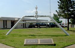
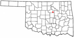
Cushing, Oklahoma — City — Pipeline Crossroads of the World monument, 2006 Location of Cushing, Oklahoma Coordinates: 35°58′57″N 96°45′51″W / 35.9825°N 96.76417°WCoordinates: 35°58′57″N 96°45′51″W / 35.9825°N 96.76417°W Country United States State Oklahoma County Payne Area - Total 7.6 sq mi (19.8 km2) - Land 7.6 sq mi (19.8 km2) - Water 0.0 sq mi (0.0 km2) Elevation 935 ft (285 m) Population (2000) - Total 8,371 - Density 1,096.1/sq mi (423.2/km2) Time zone Central (CST) (UTC-6) - Summer (DST) CDT (UTC-5) ZIP code 74023 Area code(s) 539/918 FIPS code 40-18850[1] GNIS feature ID 1091897[2] Cushing is a city in Payne County, Oklahoma, United States. The population was 8,371 at the 2000 census.
The city was established after the Land Run of 1891 by Billy Rae Little.[3] It was named for Marshall Cushing, private secretary to U.S. Postmaster General John Wanamaker.[3] An oil boom that began in 1912 led to the city's development as a refining center.[3]
Today, Cushing is a major trading hub for crude oil and a famous price settlement point for West Texas Intermediate on the New York Mercantile Exchange.[4]
Contents
History
The area that would become Cushing was part of the Sac and Fox Reservation. With the Land Run of 1891, government trader for the tribe Billy Rae Little built a house, established his claim, and laid out town lots.[3] The town got a post office late that year and was named for Marshall Cushing, private secretary to U.S. Postmaster General John Wanamaker.[3]
In 1902, the Eastern Oklahoma Railway line to Cushing was built. The Missouri, Kansas and Texas Railway added service on its own line built in 1903.[3]
Wildcatter Thomas B. Slick started an oil boom on March 17, 1912 when he brought in a gusher east of the town.[3] Oil production became based in nearby Drumright, Oklahoma, and Cushing became a refining center.[3]
Geography
Cushing is located in Payne County, Oklahoma at the intersection of state highways 33 and 18. Its geographic coordinates are 35°58′57″N 96°45′51″W / 35.9825°N 96.76417°W (35.982628, -96.764171)[5]. According to the United States Census Bureau, the city has a total area of 7.6 square miles (20 km2), of which, 7.6 square miles (20 km2) is land and 0.13% is water.
Climate
Climate data for Cushing, Oklahoma Month Jan Feb Mar Apr May Jun Jul Aug Sep Oct Nov Dec Year Record high °F (°C) 81
(27)83
(28)92
(33)101
(38)100
(38)108
(42)117
(47)112
(44)110
(43)99
(37)85
(29)82
(28)117
(47)Average high °F (°C) 48
(9)54
(12)61
(16)73
(23)80
(27)89
(32)94
(34)95
(35)88
(31)76
(24)62
(17)52
(11)73 Average low °F (°C) 25
(−4)30
(−1)36
(2)49
(9)59
(15)67
(19)71
(22)70
(21)61
(16)51
(11)37
(3)29
(−2)49 Record low °F (°C) −11
(−24)3
(−16)−2
(−19)23
(−5)32
(0)45
(7)55
(13)51
(11)35
(2)24
(−4)10
(−12)−1
(−18)−11
(−24)Precipitation inches (mm) 1.3
(33)1.6
(41)2.1
(53)3.5
(89)5.8
(147)5.1
(130)4.3
(109)2.7
(69)3.7
(94)3
(76)1.6
(41)1.3
(33)35.8
(909)Snowfall inches (cm) 3.6
(9.1)2.1
(5.3)1.3
(3.3)0.1
(0.3)0.3
(0.8)1.4
(3.6)8.8
(22.4)% humidity 70 68 63 62 70 69 66 64 63 63 61 66 65 Avg. rainy days 3.3 3.9 5 6.5 7.4 7.8 7.1 5.2 5.9 5 3.1 3.3 63.5 Source no. 1: weather.com Source no. 2: Weatherbase.com [6] Demographics
As of the census[1] of 2000, there were 8,371 people, 3,071 households, and 2,002 families residing in the city. The population density was 1,096.1 people per square mile (423.0/km²). There were 3,636 housing units at an average density of 476.1 per square mile (183.8/km²). The racial makeup of the city was 79.66% White, 7.02% African American, 7.97% Native American, 0.13% Asian, 0.90% from other races, and 4.32% from two or more races. Hispanic or Latino of any race were 2.70% of the population.
There were 3,071 households out of which 29.9% had children under the age of 18 living with them, 48.7% were married couples living together, 12.4% had a female householder with no husband present, and 34.8% were non-families. 31.3% of all households were made up of individuals and 16.1% had someone living alone who was 65 years of age or older. The average household size was 2.39 and the average family size was 2.99.
In the city the population was spread out with 22.9% under the age of 18, 10.0% from 18 to 24, 29.5% from 25 to 44, 20.0% from 45 to 64, and 17.6% who were 65 years of age or older. The median age was 37 years. For every 100 females there were 111.4 males. For every 100 females age 18 and over, there were 115.6 males.
The median income for a household in the city was $26,483, and the median income for a family was $32,284. Males had a median income of $26,710 versus $17,711 for females. The per capita income for the city was $12,620. About 15.1% of families and 16.4% of the population were below the poverty line, including 21.0% of those under age 18 and 10.1% of those age 65 or over.
Oil industry
Currently
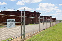
Cushing is a major hub in oil supply connecting the Gulf Coast suppliers with northern consumers. Cushing is famous as a price settlement point for West Texas Intermediate on the New York Mercantile Exchange[4] and has been cited[7] as the most significant trading hub for crude oil in North America. As of 2007, Cushing holds 5 to 10 percent of the total U.S. crude inventory. Signs made of a pipe and valve on the major highways near town proclaim Cushing to be the "Pipeline Crossroads of the World", and the town is surrounded by several tank farms. Most storage tanks are owned by four entities: oil giant BP, and energy-transport and logistics firms Enbridge Energy Partners, Plains All American Pipeline, and SemGroup Energy Partners. On July 13, 2010, BP announced it will sell its assets in Cushing to Magellan Midstream Partners.[8]
On April 13, 2007, the now-defunct Lehman Brothers released a study which claimed that WTI Crude at Cushing is no longer an accurate gauge of world oil prices.[9] A large stockpile of oil at the facility (mainly due to a Valero refinery shutdown[10]) has caused prices to be artificially depressed at the Cushing pricing point. This gap relative to world markets increased in early 2009 to nearly $12 per barrel at times, causing Saudi Arabia, a leading oil exporter and OPEC member, to announce an end to benchmarking its own oil prices to WTI.[11]
Cushing will be the southernmost hub of the proposed 2,148-mile (3,457 km) Keystone Pipeline that will transport up to 590,000 barrels per day (94,000 m3/d) of crude oil from Hardisty, Alberta to a huge tank farm in Patoka, IL. From there there is distribution to a refinery in Wood River, Illinois, as well as to the Cushing Hub.[12]
In 2006, with production increases from Canadian oil sands, one pipeline reversed direction, bringing crude into the Cushing Hub, rather than delivering crude from Cushing to oil refineries.
The Enbridge’s Spearhead line connects Chicago and Cushing with a 125,000 barrels per day (19,900 m3/d) pipeline.[13]
Historically
In the early 20th century, Cushing was a center for exploration of and production from nearby oil fields. At least two refineries operated in the town. As the oil fields started to run dry, starting in the 1940s, production and refining became less important. However, the maze of pipelines and tanks that had been built led to the NYMEX choosing Cushing as the official delivery point for its light sweet crude futures contract in 1983.
Education
The Cushing school district has seven schools that include a preschool, four elementary schools, a middle school, and a high school. The district serves approximately 1,800 students.[14]
List of schools
- Cushing High School
- Cushing Middle School
- Deep Rock Elementary School
- Harmony Elementary School
- Harrison Elementary School
- Sunnyside Elementary School
- Wilson School
References
- ^ a b "American FactFinder". United States Census Bureau. http://factfinder.census.gov. Retrieved 2008-01-31.
- ^ "US Board on Geographic Names". United States Geological Survey. 2007-10-25. http://geonames.usgs.gov. Retrieved 2008-01-31.
- ^ a b c d e f g h Cushing, Encyclopedia of Oklahoma and History (accessed June 9, 2010).
- ^ a b "Light Sweet Crude Oil Futures". http://www.nymex.com/CL_spec.aspx.
- ^ "US Gazetteer files: 2010, 2000, and 1990". United States Census Bureau. 2011-02-12. http://www.census.gov/geo/www/gazetteer/gazette.html. Retrieved 2011-04-23.
- ^ "Historical Weather for Cushing, Oklahoma, United States". http://www.weatherbase.com/weather/weatherall.php3?s=937&refer=.
- ^ 2005 OK Refinery Report PDF Download
- ^ "Magellan snaps up BP midstream package". Upstream Online (NHST Media Group). 2010-07-13. http://www.upstreamonline.com/live/article221489.ece. Retrieved 2010-07-13.
- ^ Bloomberg.com: Energy
- ^ Bloomberg.com: Energy
- ^ "Saudi drops WTI oil contract," Financial Times (accessed June 9, 2010).
- ^ http://www.courierpress.com/news/2009/oct/03/oil-pipeline-on-track-to-reach-patoka-in-2010/ (accessed October 19, 2010)
- ^ http://www.enbridgeus.com/Main.aspx?id=230&tmi=230&tmt=1 (accessed October 19, 2010)
- ^ Cushing School District, Education.com (accessed June 9, 2010).
External links
- Cushing Chamber of Commerce
- Cushing Industrial Authority (economic development)
- Encyclopedia of Oklahoma History and Culture - Cushing
- Cushing High School History In Pictures
- Cushing High School Mid-Century Yearbook - Vivacity
- Pieces of Cushing HIgh School History
- Cushing High School Alumni Association (THE ONLY OFFICIAL CHS ALUMNI ASSOCIATION WEBSITE)
- Cushing Public Schools
- KUSH Cushing High School Alumni
- Cushing 2009
Municipalities and communities of Payne County, Oklahoma County seat: Stillwater Cities Cushing | Drumright‡ | Perkins | Stillwater | Yale
Towns Unincorporated
communitiesGhost town Footnotes ‡This populated place also has portions in an adjacent county or counties
Categories:- Populated places in Payne County, Oklahoma
- Cities in Oklahoma
- History of oil in Oklahoma
Wikimedia Foundation. 2010.


