- Oklahoma State Highway 19
-
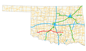
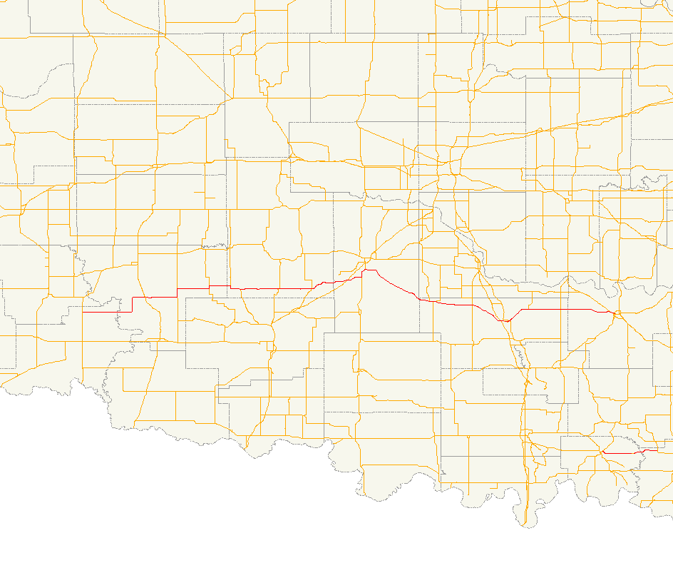
State Highway 19
Route information Maintained by ODOT Length: 172 mi (277 km) Major junctions West end: 
 US-283/SH-6 in Blair
East end: 


 SH-1/SH-3/SH-3E/SH-3W west of Ada
Highway system Oklahoma State Highways
Oklahoma turnpike system←  SH-18
SH-18SH-20  →
→State Highway 19, also known as SH-19 or OK-19, is a 172 mile[1] (278.6 km) long highway running through the southern part of the U.S. state of Oklahoma. It is signed east–west. SH-19 is Oklahoma's 13th longest state highway.[1]
Contents
Route description
 SH-19 westbound at SH-76. This sign is unusual because the arrows are normally placed under the highway shields.
SH-19 begins at an intersection with US-283 in Blair, Oklahoma. SH-19 heads east from Blair for 23 miles (37 km) without intersecting another highway before meeting U.S. Highway 183 north of Roosevelt. It continues eastward, sharing a 3 mile (4.8 km) section of road with State Highway 54 before splitting off to the east and briefly overlapping with SH-115 and State Highway 58.
The next town Highway 19 encounters is Apache, north of Lake Ellsworth, where it crosses U.S. Highway 62/281. Nine miles (14½ km) later, it overlaps with U.S. Highway 277 at Cyril. These two overlap with US-81 near Ninnekah, but SH-19 splits off to the east once again within 3 miles (4.8 km).
After splitting off, SH-19 travels in a southeast direction to have a brief concurrency with State Highway 76 through Lindsay. 10 miles (16 km) later it intersects with State Highway 74 at a four-way stop in Maysville. Still continuing southeast, 10 miles (16 km) later it has an interchange with Interstate 35 and an intersection with U.S. Highway 77 in Pauls Valley.
After passing through the Pauls Valley area, SH-19 crosses U.S. Highway 177 west of Stratford, Oklahoma. It then ends, concurrent with SH-3W at the Richardson Loop outside of Ada.[2]
Spurs
SH-19 once had two lettered spurs. They have both been decommissioned[3] but they continue to appear on state highway maps.[2]
- SH-19C once ran for one mile (1.6 km) from SH-19 to Alex. It was commissioned on August 7, 1950.[4]
- SH-19D once ran for one mile (1.6 km) from SH-19 to Bradley.
Junction list
County Location Mile[1] Destinations Notes Jackson Blair 0.0 US-283/SH-6Western terminus Kiowa Roosevelt 22.7  US-183
Cooperton 31.5  SH-54
SH-54Southern end of SH-54 concurrency 34.5 SH-54Northern end of SH-54 concurrency 43.4  SH-115
Western end of SH-115 concurrency 44.4 SH-115Eastern end of SH-115 concurrency Caddo 50.4  SH-58
SH-58Western end of SH-58 concurrency 54.4 SH-58Eastern end of SH-58 concurrency Apache 64.9 
 US-62/281
Western end of US-62/281 concurrency 65.4 US-62/281Eastern end of US-62/281 concurrency Cyril 74.3  US-277
Western end of US-277 concurrency 75.3  SH-8
SH-8Southern terminus of SH-8 Grady Ninnekah 90.5  US-81
US-81Southern end of US-81 concurrency 93.5 US-81/277Northern end of US-81 concurrency, eastern end of US-277 concurrency Alex  SH-19C
Southern terminus of SH-19C Bradley  SH-19D
Southern terminus of SH-19D Garvin Lindsay 115.8  SH-76
SH-76Western end of SH-76 concurrency 116.8 SH-76Eastern end of SH-76 concurrency 117.8  SH-59B
Southern terminus of SH-59B Maysville 127.9  SH-74
SH-74Pauls Valley 137.9  I-35
I-35I-35 exit 72 140.4  US-77
US-77147.7  SH-133
Southern terminus of SH-133 Stratford 156.7  US-177
Pontotoc 170.8 SH-3WWestern end of SH-3W concurrency Ada 147.7 SH-1/3EEastern terminus; SH-3W merges with SH-3E to become SH-3 1.000 mi = 1.609 km; 1.000 km = 0.621 mi
Concurrency terminus • Closed/Former • Incomplete access • UnopenedReferences
- ^ a b c Stuve, Eric. "OK-19". OKHighways. http://www.okhighways.com/ok19.html. Retrieved 2006-02-21.
- ^ a b Oklahoma Department of Transportation. Official State Map (Map) (2003-2004 ed.).
- ^ McMahon, Martin (2004-02-09). "Defunct State Highways". Roadklahoma. http://roads.tulok.net/x0.html. Retrieved 2006-02-21.
- ^ Oklahoma Department of Transportation, Planning & Research Division. "Memorial Dedication & Revision History - SH-19C". http://www.okladot.state.ok.us/memorial/legal/sh19c.htm. Retrieved 2007-05-06.
External links
Categories:- State highways in Oklahoma

Wikimedia Foundation. 2010.