- Oklahoma State Highway 59
-
State Highway 59
Route information Maintained by ODOT Length: 93.9 mi (151.1 km) Existed: 1932[1] – present Major junctions West end:  SH-39 north of Criner
East end: 


 US-270 BUS/SH-56 in Wewoka
Highway system Oklahoma State Highways
Oklahoma turnpike system←  US-59
US-59US-60  →
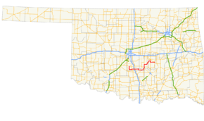
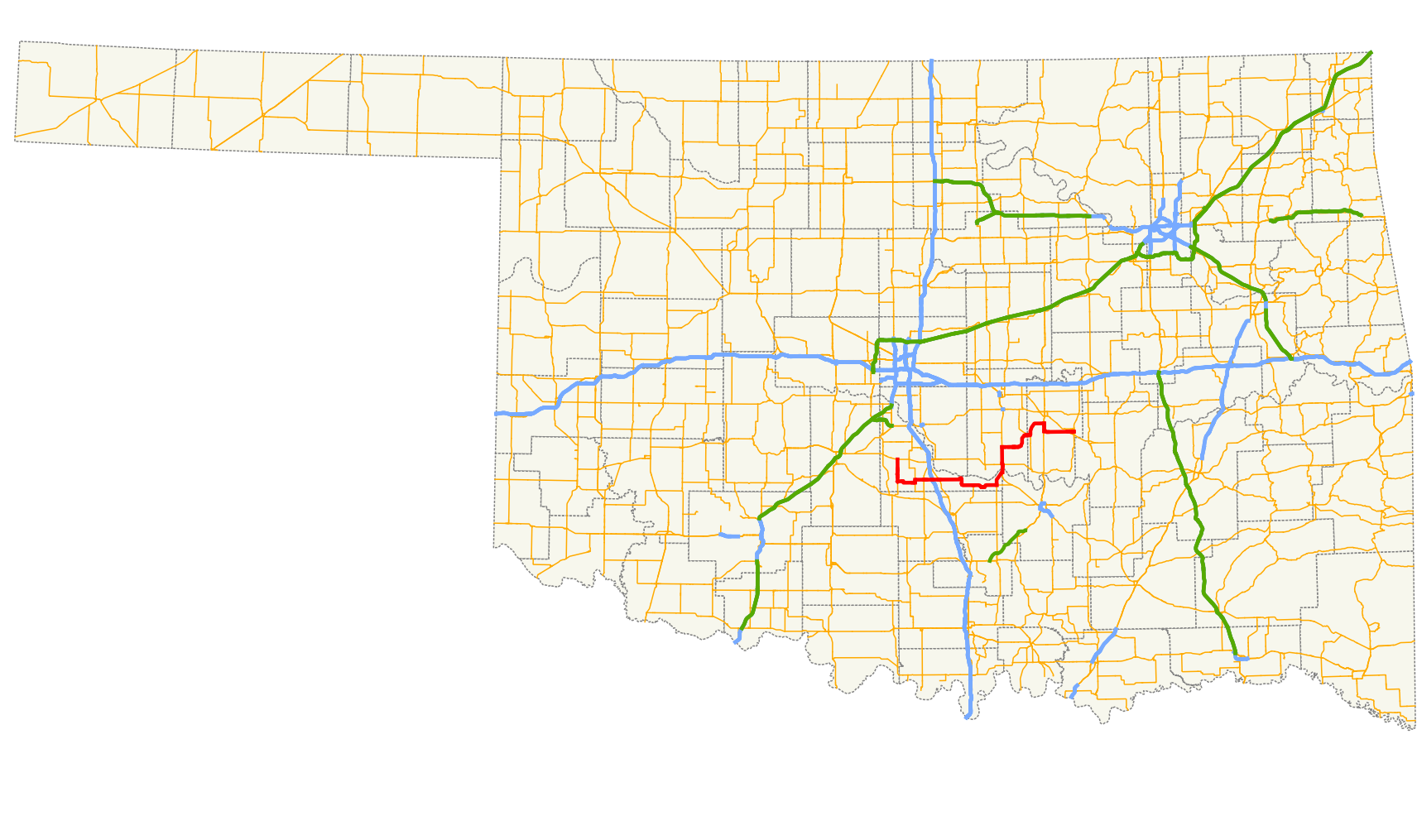
→State Highway 59, also known as SH-59 or OK-59, is a 94-mile[2] (151 km) state highway in central Oklahoma. It runs from Criner, Oklahoma in McClain Co. to Wewoka.
Contents
Route description
SH-59 begins at SH-39 north of Criner and immediately heads due south through that town. It turns due east six miles (9.6 km) north of Lindsay, serving Payne instead. After a 1-mile (1.6 km) concurrency with SH-24, SH-59 crosses SH-74 and has an interchange with I-35.
Shortly after passing under the Interstate, it meets US-77 south of Wayne, and passes through the small towns of Rosedale and Byars. Five miles (8 km) east of Byars, it meets U.S. Highway 177 and turns northward to join with it. SH-3W joins the concurrency five miles later.
The three highways cross over the South Canadian River to enter Pottawatomie Co. just south of Asher. In Asher, SH-59 meets SH-39 a second time, and six miles (10 km) later it splits off from US-177 and SH-3W to head east again, through St. Louis, Oklahoma and Maud. It forms a concurrency with US-377/SH-99/SH-3E south of Seminole, before splitting off near Bowlegs. It meets US-270 west of Wewoka, and then ends two miles (3 km) later.
History
SH-59 was first added to the state highway system in 1932 and was entirely contained within McClain County, running from Wayne to State Highway 18 (present-day US-177).[1] It was extended eastward to end at SH-48 (present-day US-377/SH-99) north of Bowlegs in 1947 or 1948.[3] It was extended to its present eastern terminus in 1965 or 1966,[4] and no significant changes have been made since.
Spurs
- SH-59A (5 mi/8 km) runs from US-177/SH-59 east to connect with SH-3W south of SH-59's own connection with the highway. This allows eastbound travelers to more easily access Ada.
- SH-59B (6 mi/10 km) runs from SH-59 south to connect with SH-19 just east of Lindsay.
Junction list
County Location Mile[2] Destinations Notes McClain 0.0 SH-39Western terminus 7.8  SH-59B
14.4  SH-24
SH-2415.4 SH-2418.4  SH-74
SH-74Wayne 21.3  I-35
I-35Diamond interchange, I-35 exit 86 21.9  US-77
US-7737.6  SH-133
Northern terminus of SH-133 46.2  SH-59A
Western terminus of SH-59A 46.2  US-177
51.2  SH-3W
SH-3WPottawatomie Asher 53.9 SH-39Pearson 60.0 US-177/SH-3WMaud 71.1  SH-9A
SH-9A72.5 SH-9ASeminole 80.2 

 US-377/SH-3E/99
Bowlegs 82.9 US-377/SH-3E/99Wewoka 91.2 US-27093.3
US-270 BUS/SH-56Eastern terminus 1.000 mi = 1.609 km; 1.000 km = 0.621 mi References
- ^ a b Oklahoma Department of Highways. Map Showing Condition of Improvement of the State Highway System (Map) (June 1932 ed.). http://www.odot.org/hqdiv/p-r-div/maps/state-maps/pdfs/1932.pdf.
- ^ a b Stuve, Eric. "OK-59". OKHighways. http://www.okhighways.com/ok59.html. Retrieved 2006-04-02.
- ^ Oklahoma Department of Highways. Map of Oklahoma's State Highway System (Map) (1948 ed.). http://www.odot.org/hqdiv/p-r-div/maps/state-maps/pdfs/1948.pdf.
- ^ Oklahoma Department of Highways. Map of Oklahoma (Map) (1966 ed.). http://www.odot.org/hqdiv/p-r-div/maps/state-maps/pdfs/1966.pdf.
Categories:- State highways in Oklahoma

Wikimedia Foundation. 2010.