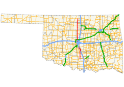
- Oklahoma State Highway 74
-
State Highway 74
Route information Maintained by ODOT Existed: 1927 (as SH-44)[1]
Became SH-74 in 1931[2] – presentSection 1 Length: 52.6 mi (84.7 km) South end:  SH-7 near Tatums
North end:  I-35 in Goldsby
Section 2 Length: 91.5 mi (147.3 km) South end: 

 I-44/SH-3/SH-6 in Bethany
North end:  SH-11 west of Deer Creek
Highway system Oklahoma State Highways
Oklahoma turnpike system←  SH-73
SH-73US-75  →
→State Highway 74, usually abbreviated as SH-74 or OK-74 (or simply Highway 74) is the numbering of two different highways maintained by the U.S. state of Oklahoma. These highways were once a single major north–south route, connecting Oklahoma City to more rural parts of the state. The original road stretched from SH-7 near Tatums, Oklahoma to SH-11 west of Deer Creek.
Due to encroaching Interstate highways—especially Interstate 35—the middle section of the route through Norman, Moore, and Oklahoma City was decommissioned in 1979 for reasons of redundancy. However, some maps show SH-74 as concurrent with I-35, I-240, and I-44, thus linking the two sections.
The north section of the route is 91.5 miles[3] (147.25 km) in length, while the southern half is 52.6 miles[4] (84.65 km) long. This leads to a total length of 144.1 miles (231.9 km).
Contents
Route descriptions
Southern section
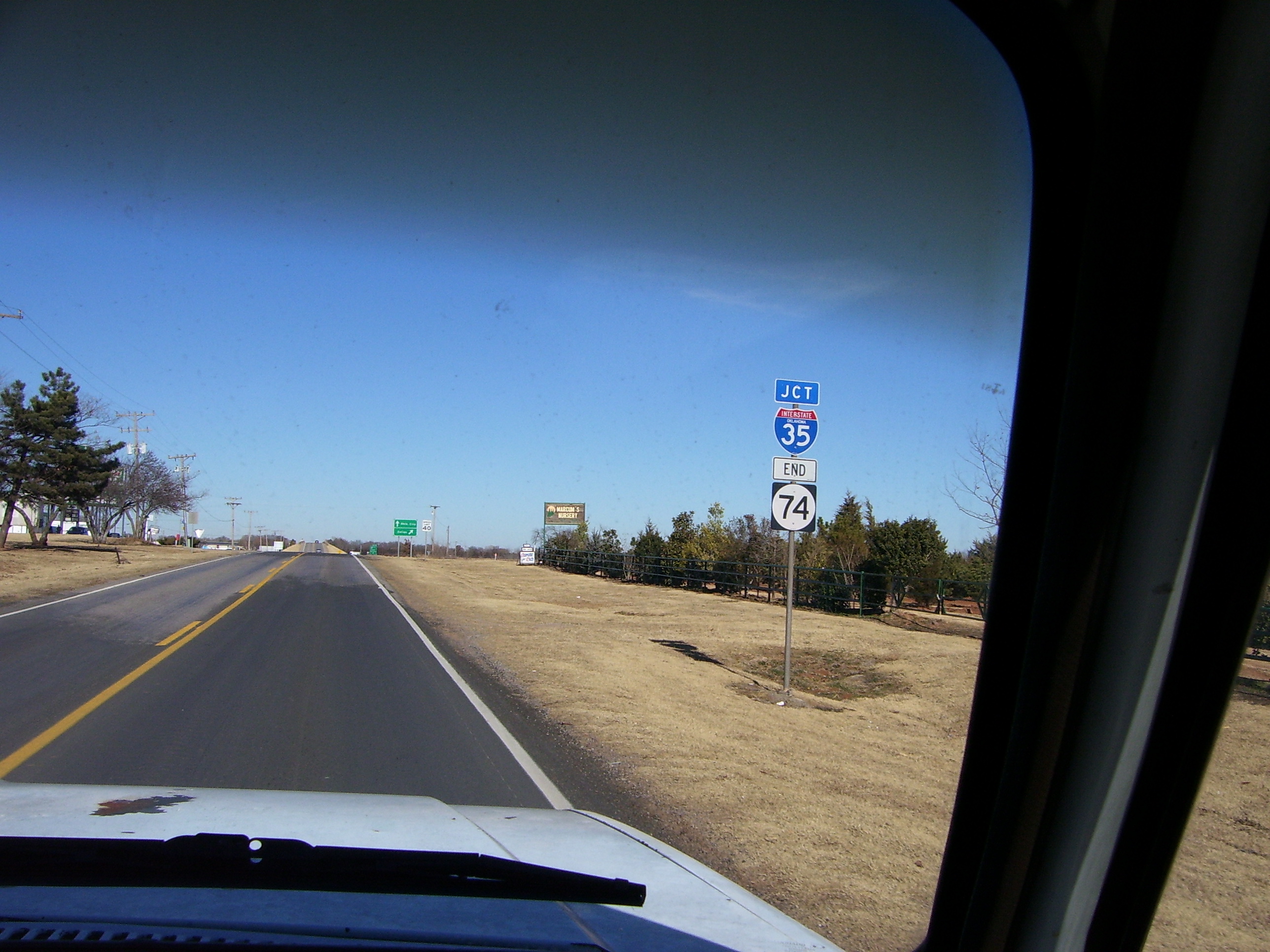
 The southern section's northern terminus, at I-35 in Goldsby.
From the southern terminus at SH-7, the southern section of SH-74 goes due north to Elmore City, where it intersects with SH-29. After a couple of turns in the Elmore City area, the highway continues due north to Maysville and SH-19. Still continuing northward, the highway meets the southern terminus of State Highway 24, and continues into Purcell.
In Purcell, SH-74 overlaps US-77 and SH-39. It finally splits off and begins heading west. From here, the highway becomes more hilly and curvy as it heads toward Washington. The road never actually enters Washington, passing just one mile[5] (1.6 km) north of it. However, Washington is accessible via SH-24, which has its northern terminus at SH-74 as well. (Both termini of SH-24 are at SH-74.)
The highway then returns to a due north course after its intersection with SH-24. It goes through the town of Goldsby and then ends at I-35.
Northern section
The highway's northern section begins at a stack interchange with Interstate 44 in Bethany. The first part of the northern section is a freeway, called the Lake Hefner Parkway because part of it runs along the east shore of Lake Hefner. The freeway, a major part of the Oklahoma City freeway system, serves the western part of Edmond. At the Kilpatrick Turnpike, the freeway comes to an end, but Highway 74 continues northward on Portland Avenue.
The road passes through the towns of Crescent, Covington, and Garber, Oklahoma as it continues, again on a due north course. Between Covington and Garber the road intersects with US-64/412, which can be used to access Enid, just 14 miles[6] (22.5 km) to the west.
Twenty miles[6] (32.2 km) north of US-412, the highway meets US-60 near Lamont. The two roads share a brief concurrency before splitting off again. Eight miles[6] (12.9 km) north of this, SH-74 intersects with SH-11 between Deer Creek and Numa, Oklahoma. It is at this intersection that the designation ends.
History

In 1927, a spur from SH-33 to Crescent was created as SH-44.[1] SH-44 was renumbered to SH-74 in 1931.[2]. On 1934-12-10, SH-74 was extended southward to Oklahoma City.[7] The highway was further extended on 1935-09-19 to Norman.[7] In 1935 and 1936, the highway's alignment through Norman was modified; it was extended from its Main Street terminus to US-77.
Also in 1936, SH-74 began expanding northward. On 1936-08-18, the designation was added to a new section of highway between Crescent and US-64[8] (now State Highway 164) in Covington.[7] Nearly a year later, the route was extended southward again. The State Highway Commission lengthened SH-74 through Goldsby and Purcell to SH-19 in Maysville on 1937-07-01.[7] The section of highway from Covington to US-60 in Lamont was added on 1941-04-14.[7] On 1945-07-05, it was extended further south to SH-29 in Elmore City (at the time simply named Elmore).[7]
Throughout the 1950s, State Highway 74 continued to be realigned and extended. Southwest of Norman, it swapped routings with SH-9 on 1954-12-06.[7] SH-74 was extended twice in 1957, once in each direction: to the north on February 18 and to the south on June 10.[7] The 1957 lengthening brought SH-74 to its greatest length, with its present-day northern terminus and a southern terminus at State Highway 53 near Milo.
By 1967, I-35 had been constructed through Oklahoma City. On 1967-01-04, SH-74 was split into two sections, with the removal of the section between Goldsby and Norman.[7] The southern section was truncated on 1974-12-02, bringing the highway to its current southern terminus.[7] The gap between the two sections of SH-74 was widened on 1975-03-05, when the route was eliminated through Cleveland County and much of Oklahoma City, bringing SH-74 to its present day termini.[7]
The Lake Hefner Parkway opened in 1992. SH-74 was transferred to the new freeway on 1992-04-06.[7]
Spurs
SH-74 has five spur routes (starting at B, and going up to a suffix of F)
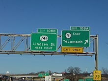 I-35 approaching SH-74A (Lindsey Street) in Norman (shield has since been removed following the 2009 decommissioning).
- SH-74A (2.7 mi, 4.3 km)[9] ran along Lindsey Street in Norman, connecting I-35 to US-77. This highway ran straight through the University of Oklahoma campus. It connected to the section of SH-74 which was converted to I-35. This highway was decommissioned in April 2009.
- SH-74B (10.0 mi, 16.1 km)[10] connects SH-74 in Goldsby to SH-76 south of Blanchard. Cole lies along the middle of this hilly spur.
- SH-74C (11.6 mi, 18.7 km)[11] connects SH-74 in Crescent to US-77 north of Guthrie.
- SH-74D (2.9 mi, 4.7 km)[12] connects SH-74 to the unincorporated community of Lovell.
- SH-74E (5 mi, 8.1 km)[13] goes from SH-51 north to Marshall, and then it goes east and ends at SH-74. This spur was commissioned on 1951-08-06.[7]
- SH-74F (8.0 mi, 12.9 km)[14] goes from SH-74 west to Cashion, and then goes north to SH-33.
- Historically, Green Avenue on the north side of Purcell from SH-74 to I-35 was designated SH-74G.[15][16] However, this designation was removed, and is currently signed as To NORTH I-35.
Junction list
Southern section
County Location Mile[4] Destinations Notes Carter 0.0 SH-7Southern section's southern terminus Garvin Elmore City 9.5  SH-29
SH-29Maysville 23.1  SH-19
SH-1925.8  SH-24
SH-24Southern terminus of SH-24, junction lies on Garvin/McClain county line McClain 29.8  SH-59
SH-59Purcell 35.1 I-35I-35 Exit 91 35.5  US-77 (Weedn Blvd.)
36.4  SH-39
SH-3937.4 US-77/SH-39 (Washington St.)Goldsby 47.1 SH-24Northern terminus of SH-24 49.1  SH-74B (Cottonwood Rd.)
Eastern terminus of SH-74B 52.6 I-35Southern section's northern terminus 1.000 mi = 1.609 km; 1.000 km = 0.621 mi Northern section
County Location Mile[3] Destinations Notes Oklahoma Oklahoma City 0.0 I-44/SH-3/SH-66Northern section's southern terminus; begin Lake Hefner Parkway (freeway) 1.1  SH-3/3A (N.W. Expy.)
6.8 Kilpatrick Tpk. Freeway ends Logan 20.1  SH-74F
Eastern terminus of SH-74F 25.1  SH-33
SH-33Crescent 31.1  SH-74C
Western terminus of SH-74C 38.2  SH-74D
Eastern terminus of SH-74D 42.3  SH-51
SH-5145.3  SH-74E
Garfield Covington 55.3  SH-164
Western terminus of SH-164 Garber 61.8 
 US-64/US-412
Diamond interchange 61.8  SH-15
SH-15SH-15 begins concurrent with SH-74 71.3 SH-15Grant 81.5  US-60
US-60Lamont 83.4 US-6091.5 SH-11Northern section's northern terminus 1.000 mi = 1.609 km; 1.000 km = 0.621 mi References
- ^ a b Oklahoma State Highway Commission. Oklahoma State Highway System 1928 (Map). http://www.odot.org/hqdiv/p-r-div/maps/state-maps/pdfs/1928.pdf.
- ^ a b Oklahoma Department of Highways (1932). Map Showing Condition of Improvement of the State Highway System (Map). http://www.odot.org/hqdiv/p-r-div/maps/state-maps/pdfs/1932.pdf. Retrieved 2007-10-14.
- ^ a b Stuve, Eric. "OK-74 (North)". OKHighways. http://www.okhighways.com/ok74n.html. Retrieved 2007-10-13.
- ^ a b Stuve, Eric. "OK-74 (South)". OKHighways. http://www.okhighways.com/ok74s.html. Retrieved 2007-10-13.
- ^ Distance signage at the SH-74/SH-24 junction.
- ^ a b c Oklahoma Department of Transportation. 2007 Centennial State Map (Map). http://www.odot.org/hqdiv/p-r-div/maps/2007state/pdfs/2007highwaymap.pdf. Retrieved 2007-10-13.
- ^ a b c d e f g h i j k l m Oklahoma Department of Transportation. "Memorial Dedication and Revision History". http://www.okladot.state.ok.us/memorial/legal/sh74.htm. Retrieved 2007-10-14.
- ^ Oklahoma Department of Highways (1937). Map Showing Condition of Improvement of the State Highway System and Landing Fields (Map). http://www.odot.org/hqdiv/p-r-div/maps/state-maps/pdfs/1937.pdf. Retrieved 2007-10-14.
- ^ Stuve, Eric. "OK-74A". OKHighways. http://www.okhighways.com/ok74a.html. Retrieved 2007-10-14.
- ^ Stuve, Eric. "OK-74B". OKHighways. http://www.okhighways.com/ok74b.html. Retrieved 2007-10-14.
- ^ Stuve, Eric. "OK-74C". OKHighways. http://www.okhighways.com/ok74c.html. Retrieved 2007-10-14.
- ^ Stuve, Eric. "OK-74D". OKHighways. http://www.okhighways.com/ok74d.html. Retrieved 2007-10-14.
- ^ Stuve, Eric. "OK-74E". OKHighways. http://www.okhighways.com/ok74e.html. Retrieved 2007-10-14.
- ^ Stuve, Eric. "OK-74F". OKHighways. http://www.okhighways.com/ok74f.html. Retrieved 2007-10-14.
- ^ McMahon, Martin. "Defunct Oklahoma State Highways". Roadklahoma. http://roads.tulok.net/x0.html. Retrieved 2007-10-14.
- ^ Google, Inc. Google Maps – Oklahoma State Highway 74 (Map). Cartography by Google, Inc. http://maps.google.com/maps?f=d&hl=en&geocode=8937936443052690978,35.013926,-97.366065&time=&date=&ttype=&saddr=OK-74+N+%4035.013926,+-97.366065&daddr=35.029619,-97.375646&mrsp=0,1&sz=17&mra=mi&sll=35.029786,-97.37438&sspn=0.003971,0.006802&ie=UTF8&ll=35.026201,-97.363501&spn=0.031769,0.054417&z=14&om=1. Retrieved 2007-10-14.
External links
Categories:- State highways in Oklahoma
- Transportation in Oklahoma City, Oklahoma


Wikimedia Foundation. 2010.