- Oklahoma State Highway 133
-
State Highway 133 
Route information Maintained by ODOT Length: 6.6 mi (10.6 km) Existed: 1958/9[1] – present Major junctions South end:  SH-19 northeast of Pauls Valley
North end:  SH-59 east of Rosedale
Highway system Oklahoma State Highways
Oklahoma turnpike system←  SH-132
SH-135  →
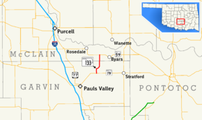
→State Highway 133 (abbreviated SH-133 or OK-133) is a short 6.6-mile (10.6 km) [2] (10.6 km) state highway in central Oklahoma, United States. has no lettered spur routes.
Contents
Route description
SH-133 runs from SH-19 seven miles (11.2 km) northeast of Pauls Valley[3] to SH-59 between Rosedale and Byars.
History
SH-133 first appeared on the 1959 state highway map[1], implying it was commissioned in either late 1958 or early 1959. Originally, the route was entirely gravel-surfaced[1] but by 1963 the Garvin County portion had been paved.[4] The road was entirely paved in 1972.[5]
Junction list
County Location Mile[2] Destinations Notes Garvin 0.0  SH-19
SH-19Southern terminus McClain 6.6  SH-59
SH-59Northern terminus 1.000 mi = 1.609 km; 1.000 km = 0.621 mi References
- ^ a b c Oklahoma Department of Highways. Oklahoma Road Map (Map) (1959 ed.). http://www.odot.org/hqdiv/p-r-div/maps/state-maps/pdfs/1959.pdf. Retrieved 2007-11-01.
- ^ a b Stuve, Eric. "OK-133". OKHighways. http://www.okhighways.com/ok133.html. Retrieved 2006-04-08.
- ^ Oklahoma Department of Transportation. Oklahoma Official State Map. 2005-2006 edition, second printing.
- ^ Oklahoma Department of Highways. Oklahoma Road Map (Map) (1963 ed.). http://www.odot.org/hqdiv/p-r-div/maps/state-maps/pdfs/1963.pdf. Retrieved 2007-11-01.
- ^ Oklahoma Department of Highways. Official State Highway Map (Map) (1973 ed.). http://www.odot.org/hqdiv/p-r-div/maps/state-maps/pdfs/1973.pdf. Retrieved 2007-11-01.
External links
Categories:- State highways in Oklahoma
Wikimedia Foundation. 2010.


