- Oklahoma State Highway 48
-
State Highway 48
Route information Maintained by ODOT Length: 160.5 mi (258.3 km) Major junctions South end:  SH-78 north of Durant
North end:  US-64 south of Cleveland
Highway system Oklahoma State Highways
Oklahoma turnpike system←  SH-47
SH-47SH-49  →
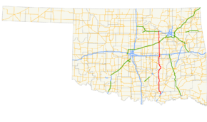
→State Highway 48 (SH-48/OK-48) is a state highway in eastern Oklahoma that runs nearly 161 miles (259 km) from Bryan County to Pawnee County.[1] SH-48 has one lettered spur in Johnston County.
Route description
SH-48 begins at SH-78 six miles (10 km) north of Durant. Running north, it is five miles (8 km) to the first highway intersection, SH-22, just west of Kenefic. Highway 48 continues on to the north, passing through the community of Folsom, and at Coleman, SH-48A spurs off to the west, towards the town of Milburn.
Seven miles ahead is Wapanucka, and the junction with SH-7. Nine miles past Wapanucka, SH-31 intersects, heading to the east, and in seven more miles Highway 48 reaches the town of Tupelo. Just north of Tupelo, SH-48 intersects SH-3, and then continues for 13 miles (21 km) to Allen, where it joins SH-1 for a seven-mile (11 km) concurrency to Atwood.
At Atwood, SH-48 splits off to the north, crosses the Canadian River, and soon enters the city of Holdenville, seat of Hughes County. SH-48 meets US-270 Business in Holdenville, then intersects US-270 just north of town. SH-48 intersects with SH-9 in northwestern Hughes County, and then turns to the east the junction with SH-99A, just west of Bearden.
Highway 48 turns back to the north soon after leaving Bearden, and crosses the North Canadian River just south of the I-40 junction. Two miles after I-40, SH-48 crosses SH-56 five miles (8 km) west of Okemah, then US-62 five miles (8 km) after that, just west of Castle.
The 25 miles (40 km) between US-62 and the SH-16 junction in Bristow is very rural, with no settlements of any size. At Bristow, SH-48 joins SH-16 and SH-66 for a short three-route concurrency through town. SH-16 branches off just north of downtown Bristow, and SH-48/SH-66 intersect with I-44/Turner Turnpike at Bristow's northern edge.
Four miles after I-44, SH-66 splits off the east, and Highway 48 continues north eight miles (13 km) to SH-33, then another nine miles (14 km) to SH-51, two miles (3 km) west of Mannford. SH-48 crosses the Cimarron River and skirts the western edge of Keystone Lake as it travels its final few miles, intersecting with US-412/Cimarron Turnpike just before terminating at US-64, eight miles (13 km) south of Cleveland.
Spurs
SH-48 has one lettered spur.
- SH-48A connects to SH-78 at Milburn, in Johnston County.
References
- ^ Stuve, Eric. "OK-48". OKHighways. http://www.okhighways.com/ok48.html. Retrieved 2006-09-19.
Categories:- State highways in Oklahoma

Wikimedia Foundation. 2010.