- Oklahoma State Highway 47
-
State Highway 47
Route information Maintained by ODOT Length: 94.6 mi[2] (152.2 km) Existed: November 12, 1936[1] – present Major junctions West end:  FM 2124 at the Texas state line
East end:  SH-33 in Thomas
Highway system Oklahoma State Highways
Oklahoma turnpike system←  SH-46
SH-46SH-48  →
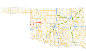
→State Highway 47 (SH-47 or OK-47) is a state highway in Oklahoma. It runs 94.6 miles (152.2 km) west-to-east in Roger Mills, Dewey and Custer counties.[2]
The current SH-47 was first established in late 1936. Over time it was expanded, reaching its current extent in 1945. A lettered spur route, SH-47A, was added in 1965.
Contents
Route description
State Highway 47 begins at the Texas state line, where FM 2124 becomes SH-47 upon entering Oklahoma, in the Black Kettle National Grassland. Four miles (6.4 km) later, SH-30 joins the highway for a three-mile (5 km) concurrency just south of Reydon.[3] Just outside the community of Rankin, SH-30 turns to the south, and SH-47 continues off to the east.
A few miles west of Cheyenne, SH-47A branches off in a loop to the north, rejoining Highway 47 in a couple of miles. South of Cheyenne, SH-47 joins US-283 for a concurrency to the north. SH-33 also joins in on the concurrency, with a signed direction opposite that of SH-47 (a wrong-way concurrency). SH-47 and US-283/SH-33 parts ways at Roll, where SH-47 resumes its travel to the east.
From Roll, the highway travels 21 miles (34 km) to a junction with SH-34 just south of Leedey.[3] SH-47 continues east for 22 miles (35 km) until it reaches a junction with US-183.[3] There, it turns to the south for a five-mile (8 km) concurrency.[3] After leaving US-183, SH-47 travels another 13 miles (21 km) to the east to its terminus at SH-33 in Thomas.[3]
History
The current incarnation of State Highway 47 was first commissioned on November 12, 1936.[1] Originally, the highway began at SH-34 south of Leedey and proceeded east to end at SH-14 (present-day US-183) south of Putnam.[4] However, the road was removed from the state highway system just over a year later, on the last day of 1937. It was brought back with the same extent on June 19, 1939.[1]
Throughout the early 1940s, SH-47 underwent a period of expansion. The first extension of the highway came on June 20, 1940, when it was extended west to end at US-283 in Roll.[1][5] SH-47 was extended east to Thomas via US-183 on May 31, 1944.[1] The final extension occurred on October 1, 1945, when the highway was extended south down US-283 to Cheyenne, then west to the Texas state line.[1]
SH-33 and SH-47 swapped places west of US-283 on July 9, 1956; SH-47 proceeded due west of Roll to the Texas state line, while SH-33 passed through Cheyenne and turned toward the west south of there.[1] This gave both highways straighter courses and resolved the wrong-way concurrency. However, the change was rescinded on August 13, 1956.[1]
Two minor realignments were done to SH-47 in the 1960s. The first, on April 3, 1961, relocated the highway west of Aledo, while the other one, on May 5, 1964, adjusted it between Roll and Angora. SH-47 has undergone no changes since.[1]
Junction list
County Location Mile[2] Destinations Notes Roger Mills 0.0 FM 2124Western terminus, Oklahoma state line Reydon 4.2  SH-30
SH-30Northern end of SH-30 concurrency Rankin 7.1 SH-30Southern end of SH-30 concurrency 18.4  SH-47A
Western terminus of SH-47A 19.9 SH-47AEastern terminus of SH-47A 20.8  US-283
Southern end of US-283 concurrency 25.4 SH-33Southern end of SH-33 concurrency Roll 33.4 US-283 / SH-33Northern end of US-283/SH-33 concurrency Dewey 54.5  SH-34
SH-3476.8  US-183
Northern end of US-183 concurrency Custer 81.8 US-183Southern end of US-183 concurrency Thomas 94.6 SH-33Eastern terminus 1.000 mi = 1.609 km; 1.000 km = 0.621 mi
Concurrency terminus • Closed/Former • Incomplete access • UnopenedSpurs

Two highways have served as branch routes during SH-47's history. Both of these bore the SH-47A designation.
Historic
Historically, SH-47A was a spur serving the central business district of Reydon. The highway was commissioned on a temporary basis on February 8, 1950. Its alignment was adjusted, and the highway received a permanent commission, on January 8, 1951. The highway was turned back over to the town on December 6, 1954.[1]
Current
The current SH-47A is a 2.15-mile (3.46 km) loop route that connects to SH-47 at both ends west of Cheyenne.[6] The highway is entirely located within Roger Mills County and the Black Kettle National Grassland. It provides access to the Washita Battlefield National Historic Site.
SH-47A was commissioned on September 7, 1965.[1]
References
- ^ a b c d e f g h i j k Oklahoma Department of Transportation. "Memorial Dedication and Revision History, SH 47". http://www.okladot.state.ok.us/memorial/legal/sh47.htm. Retrieved 2010-04-16.
- ^ a b c Stuve, Eric. "OK-47". OKHighways. http://www.okhighways.com/ok47.html. Retrieved 2006-09-20.
- ^ a b c d e Oklahoma Department of Transportation. Official State Map (Map) (2009–10 ed.). http://www.odot.org/hqdiv/p-r-div/maps/state-maps/2009state/pdfs/state-map.pdf. Retrieved 2010-04-16.
- ^ Oklahoma Department of Highways. Map Showing Condition of Improvement of the State Highway System (Map) (April 1937 ed.). http://www.odot.org/hqdiv/p-r-div/maps/state-maps/pdfs/1937.pdf. Retrieved 2010-04-16.
- ^ Oklahoma Department of Highways. Map Showing Condition of Improvement of the State Highway System (Map) (April 1941 ed.). http://www.odot.org/hqdiv/p-r-div/maps/state-maps/pdfs/1941.pdf. Retrieved 2010-04-16.
- ^ Oklahoma Department of Transportation. 2008 Control Section Maps – Roger Mills County (Map). http://www.odot.org/hqdiv/p-r-div/maps/control-maps/rogermills.pdf. Retrieved 2010-04-16.
External links
Categories:- State highways in Oklahoma


Wikimedia Foundation. 2010.