- Oklahoma State Highway 30
-
State Highway 30
Route information Maintained by ODOT Length: 84.5 mi[2] (136.0 km) Existed: March 31, 1936[1] – present Major junctions South end:  US-62 in Hollis
North end: Durham Highway system Oklahoma State Highways
Oklahoma turnpike system←  SH-29
SH-29SH-31  →
→
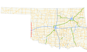
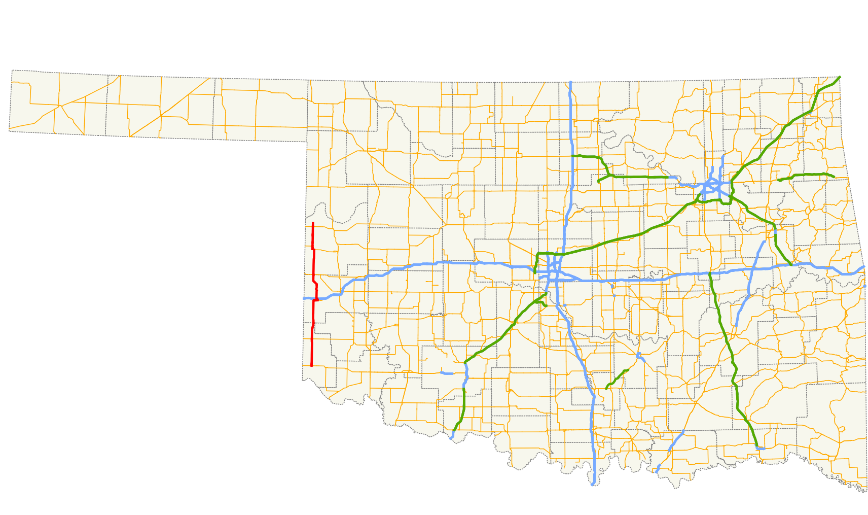
State Highway 30 (SH-30 or OK-30) is a state highway in Oklahoma. It runs 84.5 miles[2] south-to-north along the western edge of the state, from US-62 in Hollis to the town of Durham, two miles (3 km) north of SH-33. It passes through Harmon, Beckham and Roger Mills counties. The current incarnation of SH-30 dates back to March 31, 1936, when it spanned from Erick north to Sweetwater. The highway gradually evolved over the years, reaching its current form in 1970.
Contents
Route description
SH-30 begins at US-62 in Hollis, the seat of Harmon County. It travels north through very sparsely populated terrain to the unincorporated settlement of McKnight, about 6 miles (9.7 km) north of Hollis. North of McKnight, the highway crosses the Salt Fork of the Red River. SH-30 has a junction with SH-9, 9 miles (14 km) north of McKnight.[3] For the next 22 miles (35 km) through rural Western Oklahoma, SH-30 parallels the Texas state line, lying generally about 5 miles (8.0 km) west of it.[4] The highway bridges over the Elm Fork of the Red River about 2 miles (3.2 km) before crossing into Beckham County.
Two miles (3 km) west of Erick, SH-30 intersects I-40 Business Loop. SH-30 begins a concurrency with I-40 BUS, traveling east into the town. In Erick, SH-30 turns back to the north, interchanging with I-40, then crossing the North Fork of the Red River and running through the unincorporated settlement of Mayfield. About 15 miles (24 km) north of Erick, it comes to an intersection with SH-152 in Sweetwater. At this point, it crosses into Roger Mills County.[4]
From Sweetwater, SH-30 travels north 14 miles (23 km) to SH-47, which it joins for three miles (5 km), to the town of Reydon. Leaving Reydon, SH-30 continues alone across the Black Kettle National Grassland, 12 miles (19 km) to its junction with SH-33. Crossing SH-33, SH-30 continues on for two miles (3 km) to its terminus at Durham.[4]
History
State Highway 30 was added to the highway system on March 31, 1936. At this time, SH-30 began at US-66 in Erick and ended at what was then numbered SH-41 (present-day SH-152) in Sweetwater. On November 18, the highway was extended west along US-66, then south, setting its southern terminus at its present location at US-62 in Hollis.[1] The 1937 state highway map was the first to show SH-30.[5]
The following year, a large portion of the highway was removed from the state highway system. On October 19, 1937, between the SH-9 junction and US-66, the route ceased to be maintained by the Department of Highways.[1] SH-30 still appeared as such on the 1938 state highway map, but with dashed lines, indicating the route was not maintained.[6] By the 1940 edition, SH-30 was not marked at all on the map between just north of SH-9 to US-66 west of Erick. As a result, SH-30 was effectively in two sections, one running from Hollis to SH-9, and another between Erick and Sweetwater.[7]
On April 14, 1941, the southern SH-30 was extended further to the south.[1] The highway proceeded east from Hollis along US-62, then, at Gould, turned south along what was previously an unnumbered farm-to-market road. The route turned back east to end at SH-34 and SH-44 in Eldorado. This extension encompassed all of the present-day western SH-5.[8] By January 1942, however, this extension of SH-30 would be split off to form the new SH-90.[9]
The two sections of SH-30 were reunited on August 13, 1945, with the reincorporation of the SH-9 to Erick stretch into the route.[1] The newly-continuous highway was extended north three months later on November 21, when it was extended north of Sweetwater for the first time, ending in Reydon (concurrent with SH-47). On February 7, 1955, SH-30 was extended north to Durham.[1][10]
From the late 1950s through the 1960s, SH-30 extended south to the Texas state line. On February 18, 1958,[1] the highway was extended to run west along US-62, then split off to the south 2 miles (3.2 km) east of the north–south Texas state line. The highway then ended at a bridge over the Prairie Dog Town Fork of the Red River, the southern Oklahoma–Texas boundary.[11] The route was truncated back to Hollis on March 2, 1970.[1]
Junction list
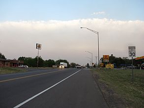
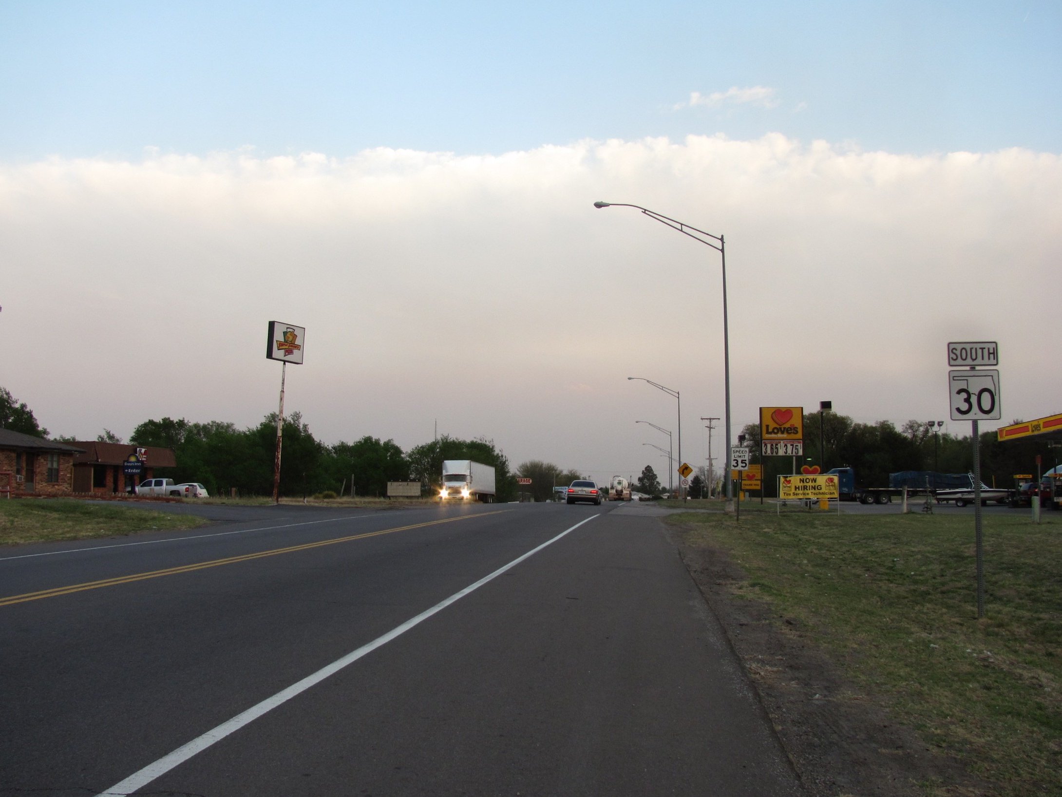
County Location Mile[2] Destinations Notes Harmon Hollis 0.0 US-62Southern terminus 15.1  SH-9
SH-9Beckham 37.0  I-40 BUS
Western end of I-40 BUS concurrency Erick 39.0 I-40 BUSEastern end of I-40 BUS concurrency 39.8  I-40
I-40Interchange, I-40 exit 7 Roger Mills Sweetwater 54.5  SH-152
Rankin 68.6  SH-47
SH-47Southern end of SH-47 concurrency Reydon 71.5 SH-47Northern end of SH-47 concurrency 82.5  SH-33
SH-33Durham 84.5 E0810 Road[3] Northern terminus 1.000 mi = 1.609 km; 1.000 km = 0.621 mi
Concurrency terminus • Closed/Former • Incomplete access • UnopenedReferences
- ^ a b c d e f g h Oklahoma Department of Transportation. "Memorial Dedication and Revision History, SH 30". http://www.okladot.state.ok.us/memorial/legal/sh30.htm. Retrieved 2010-03-19.
- ^ a b c Stuve, Eric. "OK-30". OKHighways. http://www.okhighways.com/ok30.html. Retrieved 2006-09-19.
- ^ a b DeLorme (2006). Oklahoma Atlas and Gazetteer (Map). 1:200,000.
- ^ a b c Oklahoma Department of Transportation. Official State Map (Map) (2009–10 ed.). http://www.odot.org/hqdiv/p-r-div/maps/state-maps/2009state/pdfs/state-map.pdf. Retrieved 2010-03-18.
- ^ Oklahoma Department of Highways. Map Showing Condition of Improvement of the State Highway System (Map) (April 1937 ed.). http://www.odot.org/hqdiv/p-r-div/maps/state-maps/pdfs/1937.pdf. Retrieved 2010-03-19.
- ^ Oklahoma Department of Highways. Map Showing Condition of Improvement of the State Highway System (Map) (April 1938 ed.). http://www.odot.org/hqdiv/p-r-div/maps/state-maps/pdfs/1938.pdf. Retrieved 2010-03-19.
- ^ Oklahoma Department of Highways. Map Showing Condition of Improvement of the State Highway System (Map) (April 1940 ed.). http://www.odot.org/hqdiv/p-r-div/maps/state-maps/pdfs/1940.pdf. Retrieved 2010-03-19.
- ^ Oklahoma Department of Highways. Map Showing Condition of Improvement of the State Highway System (Map) (April 1941 ed.). http://www.odot.org/hqdiv/p-r-div/maps/state-maps/pdfs/1941.pdf. Retrieved 2010-03-19.
- ^ Oklahoma Department of Highways. Map Showing Condition of Improvement of the State Highway System (Map) (January 1942 ed.). http://www.odot.org/hqdiv/p-r-div/maps/state-maps/pdfs/1942.pdf. Retrieved 2010-03-19.
- ^ Oklahoma Department of Highways. Oklahoma's Highways 1956 (Map). http://www.odot.org/hqdiv/p-r-div/maps/state-maps/pdfs/1956.pdf. Retrieved 2010-03-19.
- ^ Oklahoma Department of Highways. 1958 Oklahoma Road Map (Map). http://www.odot.org/hqdiv/p-r-div/maps/state-maps/pdfs/1958.pdf. Retrieved 2010-03-19.
External links
Categories:- State highways in Oklahoma

Wikimedia Foundation. 2010.