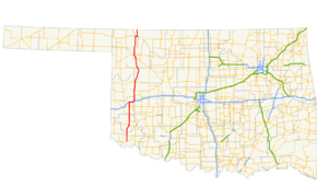
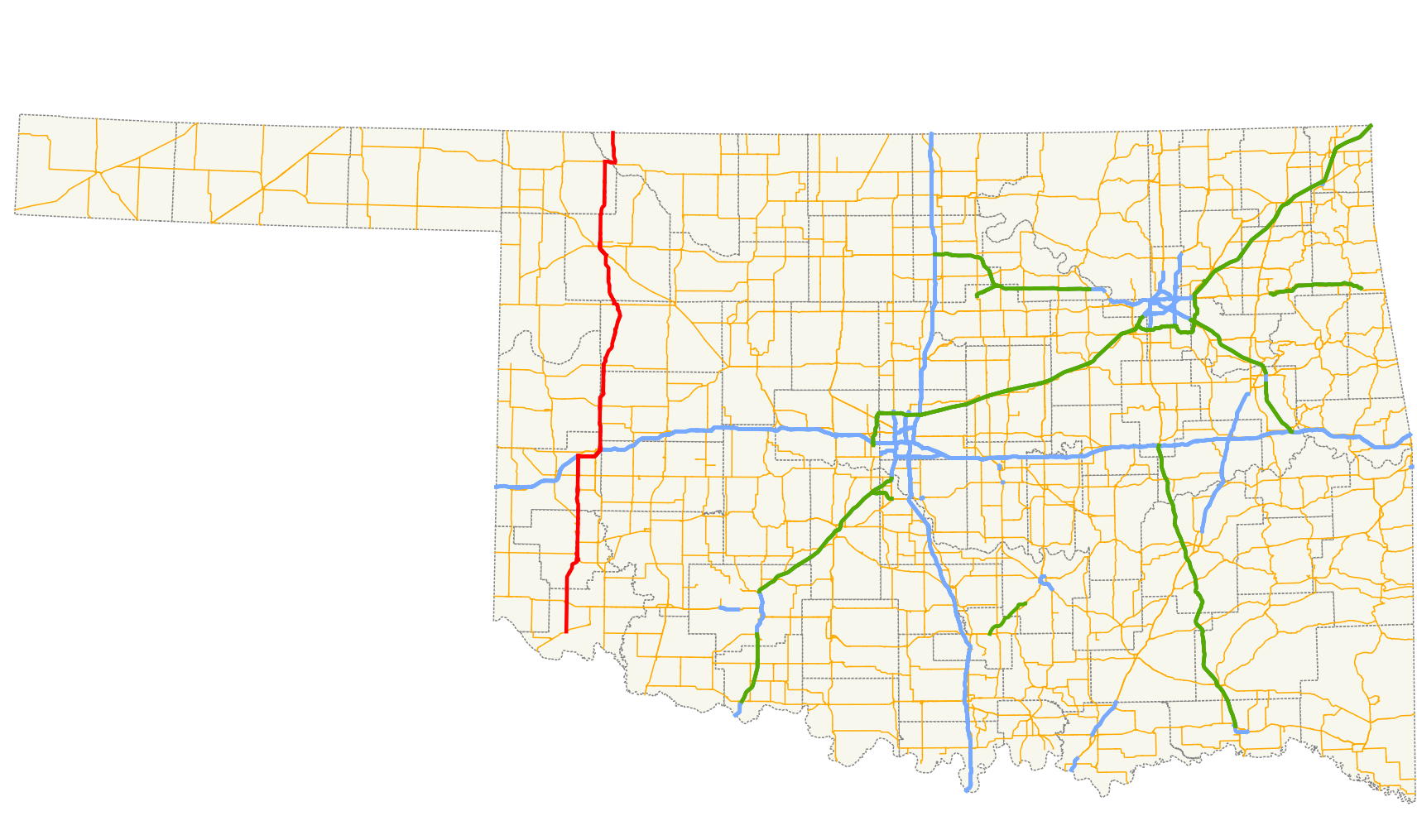
- Oklahoma State Highway 34
-
State Highway 34
Route information Maintained by ODOT Length: 188.5 mi[2] (303.4 km) Existed: June 15, 1931[1] – present Major junctions South end:  SH-6 northeast of Eldorado
North end:  K-1 at the Kansas state line
Highway system Oklahoma State Highways
Oklahoma turnpike system←  SH-33
SH-33I-35  →
→State Highway 34 (abbreviated SH-34 or OK-34) is a state highway in the U.S. state of Oklahoma. It runs for 188.5 miles (303.4 km)[2] south-to-north in the western part of the state. The highway begins northeast of Eldorado, in the southwest corner of the state, and extends north to the Kansas state line between Woodward and Coldwater, Kansas.
SH-34 has always been a lengthy highway, starting with its commissioning in June 1931, when it was a border-to-border highway stretching from Texas to Kansas. Most of SH-34 has followed the same basic corridor since its inception, with the exception of the portion of highway north of Woodward. The southernmost portion of highway, connecting it to Texas, became solely SH-6 in 1987.
There are three letter-suffixed spur highways branching from SH-34. SH-34A and SH-34B serve small towns in Greer County off the mainline of SH-34, while SH-34C serves Boiling Springs State Park.
Contents
Route description
State Highway 34 begins at SH-6 six miles (10 km) northeast of Eldorado.[3] Heading north from there, it intersects US-62 just east of Duke. The highway continues north into Greer County to its county seat of Mangum, where SH-34 joins US-283. Two miles (3 km) north of Mangum, SH-9 joins, for a four-mile (6 km) concurrency with SH-34 and US-283.[3] Thereafter, SH-9 splits off to the east.
Nine miles (14 km) north of Mangum, SH-34B branches off to the west, connecting to the town of Brinkman, and four miles (6 km) later, SH-34A branches off to the west to the town of Willow.[3] US-283 splits off to the northwest two miles (3 km) after that, and SH-34 continues north, crossing into Beckham County. SH-34 then bridges over the North Fork of the Red River. In Carter, the highway serves as the western terminus of SH-55. Five miles (8 km) north of Carter, SH-34 crosses SH-152.[3].
SH-34 continues on to an interchange with I-40 west of Elk City. Here, the highway begins a concurrency with eastbound I-40 that lasts for 6 miles (9.7 km).[3]. SH-34 exits the Interstate from the left on the east side of Elk City, turning back to the north and exiting Beckham County.
SH-34 next enters Roger Mills County. SH-73's western terminus is at SH-34 at nine miles (14 km) north of Elk City.[3] North of this junction, SH-34 lies along the Roger Mills–Custer county line, which it continues to follow as it passes through the east side of Hammon, where it meets State Highway 33. North of town, the route crosses over the Washita River, and shortly thereafter turns northeast to fully enter Custer County. Northwest of Moorewood, the highway crosses into Dewey County.[4]
SH-34 crosses SH-47 two miles (3 km) south of Leedey, and crosses the Canadian River near the unincorporated settlement of Trail. The highway then passes through Camargo. Just east of Vici, SH-34 joins US-60 and SH-51 for a one-mile (1.6 km) concurrency, then SH-34 heads north again at Vici.[3] The highway passes through Sharon north of Vici, then joins US-183/US-270/SH-3 four miles (6 km) southeast of Woodward.[3] At Woodward, SH-34 again sets off to the north alone, and right after crossing the North Canadian River, SH-34C branches to the east about two miles (3 km) north of Woodward, connecting to Boiling Springs State Park.
SH-34 joins US-64 in far eastern Harper County for a four-mile (6 km) concurrency to the east, crossing the Cimarron River 17 miles (27 km) east of Buffalo. The highway then turns back to the north, where it is 10 miles (20 km) to its terminus at the Kansas state line.[3]
History
State Highway 34 was first designated on June 15, 1931.[1] At that time, the highway began at the free bridge over the Red River north of Quanah, Texas and followed what is today SH-6 to the point that is now SH-34's southern terminus. There, it turned north, following its current alignment. Its 1931 alignment did not differ significantly from that of the present day (although it followed US-66 through Elk City prior to the establishment of I-40) until it got to Woodward. Rather than continue north out of town, the SH-34 of that day instead turned west, then north, passing through Fort Supply and crossing into Harper County just north of that town. It then began a concurrency with US-60 in Buffalo, turning east and connecting with its final segment, bringing it to the Kansas state line. Thus, SH-34 started life as a border-to-border highway.[5]
SH-34 was rerouted north of Buffalo on January 30, 1934.[1] The new alignment continued due north out of Buffalo to the Kansas state line along a new road. The old portion of SH-34 between US-64 and the Kansas state line became part of SH-50.[6]
The next major change to SH-34 occurred in 1954. On November first of that year, the highway was realigned to follow a new road extending north of Woodward, intersecting US-64 east of Buffalo, and following existing highways north of the state line.[1] This would put SH-34 on its present-day route north of Woodward.[7] SH-50 would remain concurrent with SH-34 north of US-64 until November 9, 1964.[8]
The next major change to SH-34 would be brought about by the establishment of the southern part of State Highway 6. The new highway was introduced on July 7, 1975.[9] SH-34 remained in place; the two highways were concurrent from northwest of Eldorado to the Red River bridge, where they both ended. On January 5, 1987, the redundant section of SH-34 was removed, truncating it to its current southern terminus.[1][9]
The final modification to SH-34 occurred just under a month later, on February 2, 1987, when SH-34 was realigned in Elk City[1] to follow I-40 instead of the old alignment of the now-dead US-66, which had become a business loop of I-40. No further changes have taken place since then.
Junction list
County Location Mile[2] Destinations Notes Jackson 0.0 SH-6Southern terminus Duke 10.4  US-62
US-62Greer Mangum 26.3  US-283
Southern end of US-283 concurrency 28.4  SH-9
SH-9Southern end of SH-9 concurrency 32.3 SH-9Northern end of SH-9 concurrency  SH-34B
Eastern terminus of SH-34B  SH-34A
Eastern terminus of SH-34A 40.5 US-283Northern end of US-283 concurrency Beckham Carter 50.4  SH-55
SH-55Western terminus of SH-55 55.4  SH-152
61.9  I-40
I-40Western end of I-40 concurrency, exit 32A–B Elk City 67.6 SH-6Exit 38 70.4 I-40Eastern end of I-40 concurrency, exit 41 70.6  BUS I-40
Roger Mills–Custer
county line79.7  SH-73
SH-73Western terminus of SH-73 Hammon 85.7 SH-33Custer No major junctions Dewey 100.3  SH-47
SH-47Vici 122.8 
 US-60 / SH-51
Eastern end of US-60/SH-51 concurrency 123.7 US-60 / SH-51Western end of US-60/SH-51 concurrency Woodward 141.3 

 US-183 / US-270 / SH-3
Southern end of US-183/US-270/SH-3 concurrency Woodward 145.0  US-183 / US-270 / US-412 / SH-3
Northern end of US-183/US-270/SH-3 concurrency  SH-34C
Western terminus of SH-34C 174.6  US-64
US-64Western end of US-64 concurrency Woods 178.1 US-64Eastern end of US-64 concurrency 188.5 K-1Kansas state line, northern terminus 1.000 mi = 1.609 km; 1.000 km = 0.621 mi
Concurrency terminus • Closed/Former • Incomplete access • UnopenedSpurs
- SH-34A is a 1.00-mile (1.61 km) spur connecting SH-34 with Willow, north of Mangum.[10]
- SH-34B is a 1.03-mile (1.66 km) spur connecting SH-34 with Brinkman, north of Mangum.[10]
- SH-34C is a 4.52-mile (7.27 km) spur connecting SH-34 with Boiling Springs State Park north of Woodward.[11]
References
- ^ a b c d e f Oklahoma Department of Transportation. "Memorial Dedication and Revision History, SH 34". http://www.okladot.state.ok.us/memorial/legal/sh34.htm. Retrieved 2010-04-14.
- ^ a b c Stuve, Eric. "OK-34". OKHighways. http://www.okhighways.com/ok34.html. Retrieved 2006-09-19.
- ^ a b c d e f g h i Oklahoma Department of Transportation. Official State Map (Map) (2009–10 ed.). http://www.odot.org/hqdiv/p-r-div/maps/state-maps/2009state/pdfs/state-map.pdf. Retrieved 2010-04-13.
- ^ DeLorme (2006). Oklahoma Atlas and Gazetteer (Map). 1:200,000.
- ^ Oklahoma State Highway Department. Map Showing Condition of Improvement of the State Highway System (Map) (December 1, 1931 ed.). http://www.okladot.state.ok.us/hqdiv/p-r-div/maps/state-maps/pdfs/1931gov.pdf. Retrieved 2010-04-14.
- ^ Oklahoma Department of Highways. Map Showing Condition of Improvement of the State Highway System and Landing Fields (Map) (October 1935 ed.). http://www.odot.org/hqdiv/p-r-div/maps/state-maps/pdfs/1935.pdf. Retrieved 2010-04-14.
- ^ Oklahoma Department of Highways. Oklahoma's Highways 1955 (Map). http://www.odot.org/hqdiv/p-r-div/maps/state-maps/pdfs/1955.pdf. Retrieved 2010-04-14.
- ^ Oklahoma Department of Transportation. "Memorial Dedication and Revision History, SH 50". http://www.okladot.state.ok.us/memorial/legal/sh50.htm. Retrieved 2010-04-14.
- ^ a b Oklahoma Department of Transportation. "Memorial Dedication and Revision History, SH 6". http://www.okladot.state.ok.us/memorial/legal/sh6.htm. Retrieved 2010-04-14.
- ^ a b Oklahoma Department of Transportation. 2008 Control Section Maps – Greer County (Map). http://www.odot.org/hqdiv/p-r-div/maps/control-maps/greer.pdf. Retrieved 2010-04-13.
- ^ Oklahoma Department of Transportation. 2008 Control Section Maps – Woodward County (Map). http://www.odot.org/hqdiv/p-r-div/maps/control-maps/woodward.pdf. Retrieved 2010-04-13.
External links
Categories:- State highways in Oklahoma

Wikimedia Foundation. 2010.