- Cimarron River (Arkansas River)
-
Cimarron River River  The Cimarron River, near Forgan, Oklahoma
Country United States States Colorado, Kansas, Oklahoma Cities Cushing, Oklahoma, Mannford, Oklahoma Source Confluence of Dry Cimarron River and Carrizozo Creek - location Kenton, Cimarron County, Oklahoma - elevation 4,318 ft (1,316 m) - coordinates 36°54′24″N 102°59′12″W / 36.90667°N 102.98667°W [1] Mouth Arkansas River - location Keystone Lake, at Westport, Pawnee County, Oklahoma - elevation 722 ft (220 m) - coordinates 36°10′14″N 96°16′19″W / 36.17056°N 96.27194°W [1] Length 698 mi (1,123 km) Basin 18,950 sq mi (49,080 km2) Discharge for Guthrie, Oklahoma, 65 miles (105 km) from the mouth - average 1,163 cu ft/s (33 m3/s) [2] - max 158,000 cu ft/s (4,474 m3/s) - min 0.3 cu ft/s (0 m3/s) 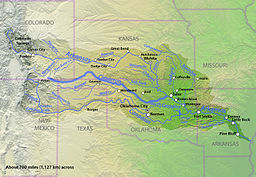 Map of the Arkansas River basin with the Cimarron River highlighted.
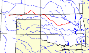 The Cimarron River (highlighted in red) flows through four states in the American West.
The Cimarron River extends 698 miles (1123 km) across New Mexico, Oklahoma, Colorado, and Kansas. The headwaters flow from Johnson Mesa west of Folsom in northeastern New Mexico. The river enters the Oklahoma Panhandle near Kenton, crosses the southeastern corner of Colorado into Kansas, re-enters the Oklahoma Panhandle, re-enters Kansas, and finally returns to Oklahoma where it joins the Arkansas River at Keystone Reservoir west of Tulsa, Oklahoma.
The river's name comes from the early Spanish name, Río de los Carneros Cimarrón, which is usually translated as River of the Wild Sheep. Early American explorers also called it the Red Fork of the Arkansas because of water's red color.
In New Mexico and extreme western Oklahoma the river is known as the Dry Cimarron River. This is by contrast to a wetter Cimarron River located further west. The Dry Cimarron River is not completely dry but sometimes its water disappears entirely under the sand in the river bed. The Dry Cimarron Scenic Byway follows the river from Folsom to the Oklahoma border. In Oklahoma the river flows along the southern edges of Black Mesa, the highest point in that state. As it first crosses the Kansas border, the river flows through the Cimarron National Grassland.
 A scene along the Dry Cimarron Scenic Byway in New Mexico
Contents
Historical notes of interest
- One branch of the Santa Fe Trail, known variously as the Cimarron Route, the Cimarron Cutoff, and the Middle Crossing (of the Arkansas River), ran through the Cimarron Desert and then along the Cimarron River.[3]:144,148
- In 1831 Comanche Indians killed Jedediah Smith (a famous hunter, trapper, and explorer) on the Santa Fe Trail near the Cimarron River. His body was never recovered.
- In 1834 General Henry Leavenworth established Camp Arbuckle (Fort Arbuckle) at the mouth of the Cimarron River.
- Historic sites along the river include the ruins of Camp Nichols, a stone fort built by Kit Carson in 1865 to protect travelers from raids by Plains Indians on the Cimarron Cutoff. It was located near present day Wheeless, Oklahoma.
- The old Chisholm Trail crossed the river at Red Fork Station near present day Dover, Oklahoma.
- On September 18, 1906, a bridge across the Cimarron near Dover, Oklahoma Territory, collapsed beneath a Rock Island train bound for Fort Worth, Texas from Chicago. The bridge was a temporary structure unable to withstand the pressure of debris and high water. Replacement with a permanent structure had been delayed by the railroad for financial reasons. Several sources report that over 100 persons were killed,[4][5][6] although this figure is disputed. The true number may be as low as 4.[7]
See also
- List of rivers of New Mexico
- List of longest rivers of the United States (by main stem)
- Cimarron National Grassland
- Maxwell National Wildlife Refuge (NWR)
- Point of Rocks (Kansas)
- Santa Fe Trail
References
- ^ a b "Cimarron River". Geographic Names Information System, U.S. Geological Survey. 1979-12-18. http://geonames.usgs.gov/pls/gnispublic/f?p=gnispq:3:::NO::P3_FID:1091369. Retrieved 2010-11-21.
- ^ "USGS Gage #07160000 on the Cimarron River near Guthrie, OK". National Water Information System. U.S. Geological Survey. 1938-2009. http://wdr.water.usgs.gov/wy2009/pdfs/07160000.2009.pdf. Retrieved 2010-11-21.
- ^ Stocking, Hobart (1971). The Road to Santa Fe. New York: Hastings House Publishers. ISBN 9780803863149.
- ^ Kite, Steven (September 20, 2000). "Corporate Greed Leads to Death in Oklahoma Territory". Oklahoma Audio Almanac. Oklahoma State University Library. http://www.library.okstate.edu/scua/exhibit/oaa/20sep00.htm. Retrieved May 18, 2010.
- ^ "Dover". Encyclopedia of Oklahoma History and Culture. Oklahoma Historical Society. http://digital.library.okstate.edu/encyclopedia/entries/D/DO011.html. Retrieved May 18, 2010.
- ^ Goins, Charles Robert; Goble, Danney (2006). Historical Atlas of Oklahoma. University of Oklahoma Press. p. 119. ISBN 0806134828.
- ^ Sencicle, Lorraine (January 2008). "Dover Oklahoma". The Daughters of Dover: Dover around the world. Dover, England: The Dover Society. http://www.doversociety.org/DofD-Oklahoma.html. Retrieved May 22, 2010.
Further reading
- Anshutz, Carrie W. Schmoker; M.W. (Doc) Anshutz. Cimarron Chronicles: Saga of the Open Range. Meade, Kansas: Ohnick Enterprises, 2003. ISBN 0-9746222-0-6
- Dary, David. The Santa Fe Trail: Its History, Legends, and Lore. New York: Penguin, 2002 (Reissue). ISBN 0-14-200058-2
- Hanners, Laverne; Ed Lord. The Lords of the Valley: Including the Complete Text of Our Unsheltered Lives. Norman: University of Oklahoma Press, 1996. ISBN 0-8061-2804-6
- Hoig, Stan. Beyond the Frontier: Exploring the Indian Country. Norman: University of Oklahoma Press, 1998. ISBN 0-8061-3052-0
- Schumm, Stanley A. Channel Widening and Flood-Plain Construction along Cimarron River in Southwestern Kansas: Erosion and Sedimentation in a Semiarid Environment. Washington D.C.: Government Printing Office, 1963. ISBN B0007EFJLY
- Schumm, Stanley A. River Variability and Complexity. New York: Cambridge University Press, 2005. ISBN 0-521-84671-4
- Stovall, John Willis. Geology of the Cimarron River Valley in Cimarron County, Oklahoma. Chicago, 1938.
- Woodhouse, S. W. (Eds. John S. Tomer, Michael J. Brodhead). A Naturalist in Indian Territory: The Journals of S.W. Woodhouse, 1849-50 (The American Exploration and Travel Series, Vol 72). Norman: University of Oklahoma Press, 1996. ISBN 0-8061-2805-4
External links
- U.S. Geological Survey Geographic Names Information System: Cimarron River
- Santa Fe Trail Research Site
- Mouth of the Cimarron TopoQuest.
- Headwaters of the Cimarron TopoQuest.
- Cimarron National Grassland USDA Forest Service.
- Dry Cimarron Scenic Byway New Mexico Historic Markers.
- Kansas connections (Eco-History Trails and Tales)
- Encyclopedia of Oklahoma History and Culture - Cimarron River
Categories:- Rivers of New Mexico
- Rivers of Oklahoma
- Rivers of Colorado
- Rivers of Kansas
- Tributaries of the Arkansas River
- Landforms of Colfax County, New Mexico
- Landforms of Union County, New Mexico
- Geography of Creek County, Oklahoma
- Geography of Osage County, Oklahoma
- Geography of Pawnee County, Oklahoma
- Geography of Tulsa County, Oklahoma
- Geography of Payne County, Oklahoma
- Geography of Logan County, Oklahoma
- Geography of Kingfisher County, Oklahoma
- Geography of Blaine County, Oklahoma
- Geography of Major County, Oklahoma
- Geography of Woods County, Oklahoma
- Geography of Woodward County, Oklahoma
- Geography of Harper County, Oklahoma
- Geography of Beaver County, Oklahoma
- Geography of Cimarron County, Oklahoma
- Geography of Baca County, Colorado
- Geography of Clark County, Kansas
- Geography of Comanche County, Kansas
- Geography of Meade County, Kansas
- Geography of Seward County, Kansas
- Geography of Haskell County, Kansas
- Geography of Grant County, Kansas
- Geography of Stevens County, Kansas
- Geography of Morton County, Kansas


Wikimedia Foundation. 2010.