- Cimarron National Grassland
-
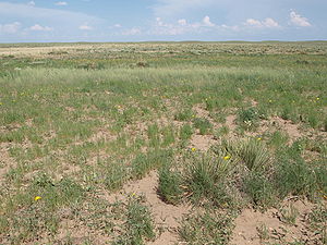
Cimarron National Grassland Protected Area Plant cover on sandy soils of the Cimarron National Grassland.Country  United States
State  Kansas
Nearest city Elkhart, Kansas Landmark Point of Rocks River Cimarron River Location Morton and Stevens County, Kansas - elevation 1,033 m (3,389 ft) - coordinates 37°07′27″N 101°47′24″W / 37.12417°N 101.79°W Area 438 km2 (169 sq mi) Biome Temperate grassland Plant Shortgrass prairie, Sand sage (Artemisia filifolia) Animal White-tailed deer, Pronghorn, Elk, Prairie Chicken, Black-footed Ferret, Black-tailed Prairie Dog, Coyotes
Designation United States National Grassland Established 23 June 1960 Management U.S. Forest Service, Kansas Department of Wildlife and Parks IUCN Category VI Cimarron National Grassland is a National Grassland located in Morton County, Kansas, United States, with a very small part extending eastward into Stevens County. [1] Cimarron National Grassland is located near Comanche National Grassland which is across the border in Colorado. The grassland is administered by the Forest Service together with the Pike and San Isabel National Forests and the Comanche National Grassland, from common headquarters located in Pueblo, Colorado. There are local ranger district offices in Elkhart, Kansas. The grassland is the largest area of public land in the state of Kansas.[1]
Contents
Geography
The Cimarron National Grassland consists of 108,175 acres of Great Plains bisected by the Cimarron River. The elevations on the Grassland range from 3,100 (945 m) to 3,700 feet (1,128 m). The terrain is mostly flat, sloping downward west to east, although bluffs rise about one hundred feet (30 m) above the valley of the Cimarron.[2] Vegetation is mostly shortgrass prairie grassland, dominated by sand sagebrush in salty soils. Groves of Cottonwood and other trees are found near the river.[3]
Climate. The climate of the National Grassland is semi-arid, receiving about 18 inches (45 cm) of precipitation annually, mostly in summer. High winds are common and further desiccate the soil. Summer temperatures are hot, with an average high of 93 (34 C) degrees and an average low of 64 (18C) in July. Winters are cold with an average high of 45 (7 C) and an average low of 18 (-8 C)in January. The all-time high temperature is 110 (43 C) and the all-time low is minus 22 (-30 C).[4]
Landmarks. The Cimarron River flows through the grassland. From late summer through winter it is usually dry above ground, yet lush vegetation still grows on the banks. Middle Spring flows year round and beaver dams create pools of water nearby.[5] Point of Rocks, a large rock outcropping overlooking the Cimarron River valley, was an important landmark for travelers heading west on the Cimarron Cutoff, and for modern day ranchers, because many springs exist in the area. Point of Rocks has an elevation of 3,540 ft (1,079 m).[6]
 Point of Rocks. In the background is the wooded valley of the Cimarron River.
History
The present-day Cimarron National Grassland was the territory of the Comanche and other Indian tribes allied to them. In 1822, William Becknell was the first to traverse the Santa Fe Trail by wagon, pioneering the alternate route called the Cimarron cut-off which passed through the National Grassland. Middle Spring was one of the three reliable sources of good water along more than 150 miles of the Cimarron Cutoff trail.[7] In or near the Grassland Mountain Man Jedediah Smith was killed by Comanches in 1831.[8]
In 1879 the Beaty brothers established Point of Rocks Ranch, the first in the area. Wheat farmers soon moved in and prospered in wet years, but the drought of the 1930s caused the Dust Bowl. Morton County was the most devastated county in the nation. The Federal government bought land from bankrupt farmers, restored the original prairie, and in 1960 the Cimarron National Grassland was created. The grassland is dedicated to “water conservation, wildlife management, recreation, cattle grazing, and mineral production.”[8] Cattle are grazed and oil and gas wells are found on the Grassland.[9]
Recreation
Access to most of the recreation opportunities in the Cimarron National Grassland are reached seven miles north of Elkhart via highway 27.
Camping, Hiking, and Horseback Riding. The grassland includes twenty-three miles of the Santa Fe National Historic Trail. The ruts left by wagon trains are still visible.[10] A mowed strip of land, called a companion trail, 19 miles long, runs alongside the Santa Fe Trail. The Turkey Trail is 10.5 miles long and runs through the wooded area along the Cimarron River. The Cimarron Recreation area offers tent and trailer camping, picnicking, a group site, and access to the Turkey Trail.
Fishing and Hunting. Several fishing ponds, including four at the Cimarron Recreation Area, are stocked with Rainbow Trout in the winter and Channel Catfish in the summer. Other sport fish include crappie and largemouth bass.[11] Crappie, sunfish, and largemouth bass are also found. Animals pursued include whitetail deer, pronghorn, prairie chicken, quail and pheasant.
Auto tour. An auto tour of approximately 30 miles on mostly dirt roads leads to most of the points of interest on the Grassland, including a prairie dog town, Point of Rocks, and the Santa Fe Trail.
Special Interests. The Cimarron Grassland has a population of rare lesser prairie chickens and has two viewing areas. The males perform their courting rituals from mid-March until early June. Elk were reintroduced into the Grassland in 1981 and a herd of 50 is maintained. Hunting by special permit is sometimes allowed to thin the herd.[12]
- ^ http://www.lasr.net/travel/city.php?Cimarron+National+Grassland+Hunting&&City_ID=&VA=Y&Attraction_ID=KS10sp001a006, accessed Jan 9, 2011
- ^ Map, DeLorme Topo 6.0
- ^ http://ecoscenarios.wikispaces.com/file/view/Ecoscenario_CimarronNG.pdf, accessed Jan 8, 2011
- ^ Climatic statistics for Elkhart, KS http://www.weather.com/outlook/recreation/outdoors/wxclimatology/monthly/graph/USKS0170, accessed Jan 8, 2011
- ^ http://www.naturalkansas.org/Cimarron.htm
- ^ DeLorme, Topo 6.0
- ^ ”Cimarron Cutoff of Santa Fe Trail.” http://www.newmexicohistory.org/filedetails.php?fileID+21278, accessed Jan 8, 2011
- ^ a b http://www.naturalkansas.org/cimarron.htm, accessed Jan 8, 2011
- ^ http://www.lasr.net/travel/city.php?Cimarron+National+Grassland+Hunting&&City_ID=&VA=Y&Attraction_ID=KS10sp001a006, accessed Jan 9, 2011
- ^ http://www.travelks.com/s/index.cfm?LID=2946, accessed Jan 9, 2011
- ^ "Cimarron Grasslands Fishing Pits / Region 3 / Fishing Locations - Public Waters / Where to Fish in Kansas / Fishing / KDWP - KDWP:". kdwp.state.ks.us. http://www.kdwp.state.ks.us/index.php/news/Fishing/Where-to-Fish-in-Kansas/Fishing-Locations-Public-Waters/Region-3/Cimarron-Grasslands-Fishing-Pits. Retrieved 2008-07-29.
- ^ http:/www.rmef.org/NewsandMedia/NewsReleases/2010/Cimarron.htm, accessed Jan 9, 2011; http://www.fs.usda.gov/wps/portal/fsinternet/!ut/p/c5/04_SB8K8xLLM9MSSzPy8xBz9CP0os3gDfxMDT8MwRydLA1cj72BTSw8jAwgAykeaxcN4jhYG_h4eYX5hPgYwefy6w0H24dcPNgEHcDTQ9_PIz03VL8iNMMgycVQEAIzTHkw!/dl3/d3/L2dJQSEvUUt3QS9ZQnZ3LzZfME80MEkxVkFCOTBFMktTNUJIMjAwMDAwMDA!/?ss=110212&navid=110000000000000&pnavid=null&cid=FSE_003741&recid=12404&ttype=recarea&navtype=BROWSEBYSUBJECT&position=BROWSEBYSUBJECT&pname=PSICC+-+Cimarron+National+Grassland, accessed Jan 9, 2011
See also
- Big Basin Prairie Preserve
- Konza Prairie
- Tallgrass Prairie National Preserve
- Flint Hills
External links
- Official government site
- Fred's Flower Finder Kansas wildflowers
Protected Areas of Kansas Federal National Wildlife Refuges:Cimarron National GrasslandState Cedar • Cheney • Clinton • Crawford • Cross Timbers • Eisenhower • El Dorado • Elk City • Fall River • Glen Elder • Hillsdale • Kaw River • Kanopolis • Lake Scott • Lovewell • Meade • Milford • Mushroom Rock • Perry • Pomona • Prairie Dog • Prairie Spirit Trail • Sand Hills • Tuttle Creek • Webster • WilsonCategories:- Grasslands of the Great Plains (U.S.)
- Landmarks in Kansas
- Protected areas of Morton County, Kansas
- National Grasslands of the United States
- Protected areas of Kansas
- Protected areas of Stevens County, Kansas
- Protected areas established in 1960
- Kansas geography stubs
- Midwestern United States protected area stubs
Wikimedia Foundation. 2010.


