- Oklahoma State Highway 20
-
State Highway 20

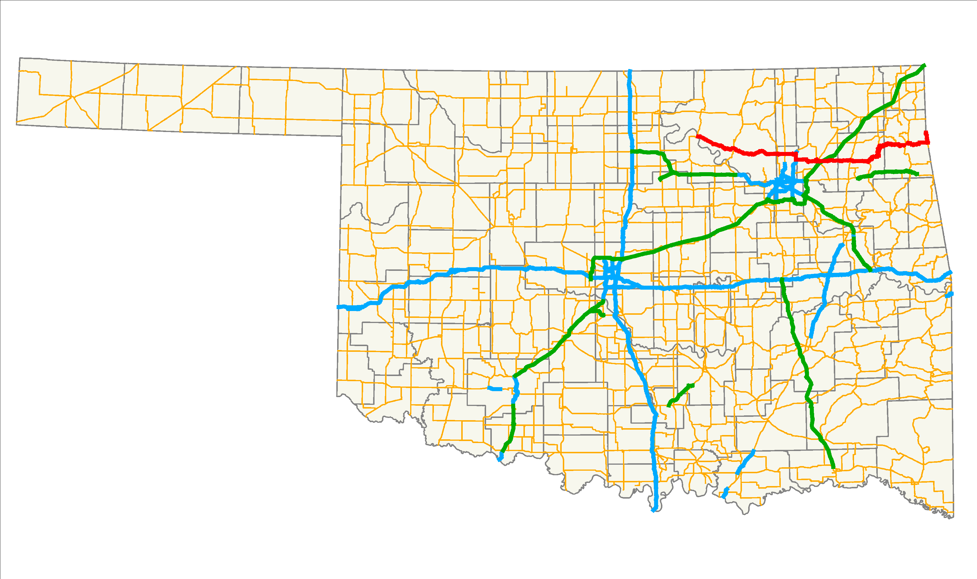
Route information Maintained by ODOT Length: 143.8 mi (231.4 km) Major junctions West end:  SH-18 near Ralston
East end:  MO-43 at the Missouri state line (concurrent with AR-43)
Highway system Oklahoma State Highways
Oklahoma turnpike system←  SH-19
SH-19SH-22  →
→State Highway 20 (abbreviated SH-20 or OK-20) is a highway in northeastern Oklahoma. Its eastern terminus is at the corner of Oklahoma, Arkansas, and Missouri near Southwest City, Missouri; its western terminus is at State Highway 18 near Ralston. The highway runs a total length of 143.8 miles[1] It has no lettered spur routes.
Contents
Route description
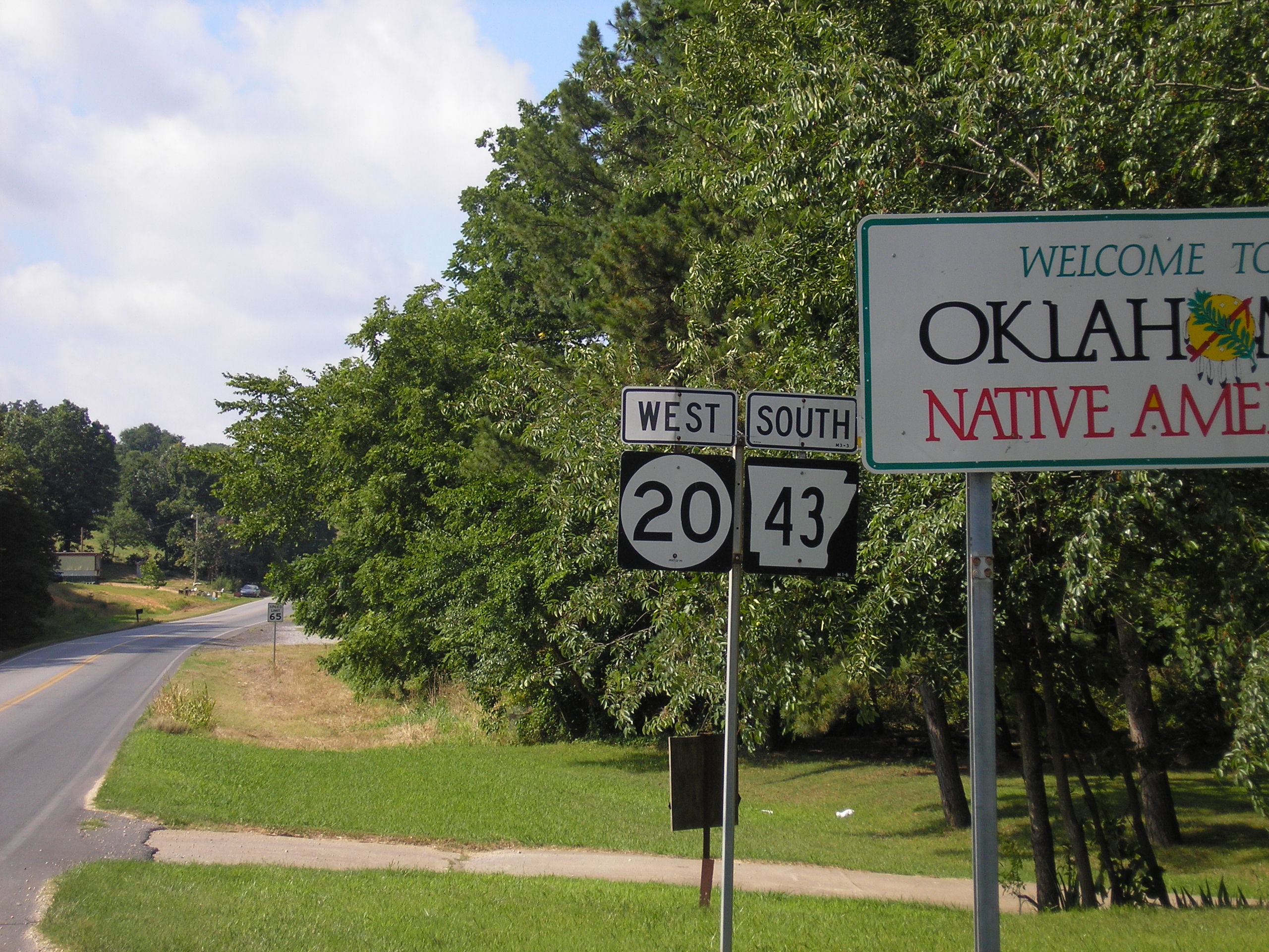
 Eastern terminus of State Highway 20 at Missouri Route 43
SH-20 begins just north of the Arkansas River at SH-18 near Ralston. From there, it heads east through Osage County for twenty miles (32 km) without crossing any other highway. At mile 20.4, it meets State Highway 99 in Hominy. East of Hominy, SH-20 crosses Lake Skiatook before passing through Skiatook and entering Tulsa County. Shortly after entering Tulsa County, SH-20 has a junction with SH-11. Four miles later, it has an interchange with US-75. After running through Collinsville, it turns southward onto the US-169 freeway.
SH-20 splits from US-169 north of Owasso. It then enters Claremore, where it meets SH-88 and SH-66 (old Route 66). It connects to the Claremore toll plaza on I-44/Will Rogers Turnpike. East of Claremore, SH-20 becomes a divided expressway before intersecting US-69 in Pryor. West of Salina,the highway bridges Lake Hudson. In Salina, SH-20 meets SH-82, which it begins a concurrency with.
Headed north from Salina, the two highways begin to cross some mountainous terrain. The highways provide access to Spavinaw State Park, before running through the town of Spavinaw, Oklahoma. North of Spavinaw, SH-20 splits off to the east, running through unincorporated Chloeta and serving as the eastern terminus of SH-28. SH-20 overlaps US-59/State Highway 10 through Jay. SH-20 then splits off to the east, running 11 miles (18 km) to the Arkansas line.
The easternmost miles run north/south along the Oklahoma–Arkansas state line, and along this stretch the highway overlaps Arkansas's Highway 43. This is the only place where two state highways from different states overlap. The highway continues northward into Missouri at the point where the Oklahoma, Arkansas and Missouri borders meet, and thereafter becomes Missouri Route 43. This unique feature has led many roadgeeks to mention SH-20/AR-43 on their websites.
History
On April 10, 2008, a section of SH-20 in Rogers County near Keetonville, west of Claremore, was closed due to a landside caused by heavy rains.[2] A 500-foot (150 m) section of roadbed was washed away, forming a large crack in the pavement and damaging the guardrail.[3] The highway was re-opened June 5, 2008 after being repaired.
Junction list
County Location Mile[1] Destinations Notes Osage Ralston 0.0 SH-18Western terminus Hominy 20.4  SH-99
SH-99Tulsa Skiatook 44.5  SH-11
SH-1148.5  US-75
US-75Diamond interchange Collinsville 54.0  US-169
Diamond interchange; SH-20 joins US-169 eastbound and splits westbound Owasso 57.1 US-169Diamond interchange; SH-20 splits US-169 eastbound and joins westbound Rogers Claremore 68.9  SH-88
SH-8869.7  SH-66
SH-6669.8 SH-66/8871.2  I-44
I-44Mayes Pryor 86.7  US-69
US-69Salina 96.8  SH-82
SH-82SH-82 joins eastbound and splits westbound Spavinaw 111.4 SH-82SH-82 splits eastbound and joins westbound Delaware 120.5  SH-28
SH-28Eastern terminus of SH-28 Jay 125.0 
 US-59/SH-10
US-59/SH-10 join eastbound and split westbound 127.1  SH-127
127.3 US-59/SH-10US-59/SH-10 split eastbound and join westbound 138.3  Arkansas Highway 43
Arkansas state line, Hwy. 43 joins eastbound and splits westbound Southwest City 143.8 Missouri Route 43Missouri state line; eastern terminus, AR-43 northern terminus 1.000 mi = 1.609 km; 1.000 km = 0.621 mi
Concurrency terminus • Closed/Former • Incomplete access • UnopenedReferences
- ^ a b Stuve, Eric. "OK-20". OKHighways. http://www.okhighways.com/ok20.html. Retrieved 2007-09-04.
- ^ Oklahoma Department of Transportation. "SH-20 closed at Keetonville Hill until further notice". http://www.odot.org/newsmedia/sh20-keetonville/index.php. Retrieved 2008-04-29.
- ^ Oklahoma Department of Transportation. "SH-20 Keetonville Pictures". http://www.odot.org/newsmedia/sh20-keetonville/pictures.htm. Retrieved 2008-04-29.[dead link]
External links
Categories:- State highways in Oklahoma

Wikimedia Foundation. 2010.