- Chloeta, Oklahoma
-
Coordinates: 36°25′23″N 94°58′15″W / 36.4231395°N 94.9707921°W
Chloeta (or Topsy) is a small rural community located on State Highway 20 in Delaware County, Oklahoma, north of Spavinaw Lake. The post office existed from April 18, 1898, until January 31, 1914.
Sources
- Shirk, George H. Oklahoma Place Names. Norman: University of Oklahoma Press, 1987. ISBN 0-8061-2028-2 .
Municipalities and communities of Delaware County, Oklahoma Cities 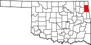
Towns Bernice | Colcord | Kansas | Oaks‡ | West Siloam Springs
CDPs Brush Creek | Bull Hollow | Cayuga | Cleora | Cloud Creek | Copeland | Dennis | Dodge | Dripping Springs | Flint Creek | Leach | New Eucha | Old Eucha | Rocky Ford | Sycamore | Tagg Flats | Twin Oaks | Zena
Unincorporated
communitiesChloeta | Eucha | Kenwood | Moseley | Turkey Ford
Footnotes ‡This populated place also has portions in an adjacent county or counties
Categories:- Populated places in Delaware County, Oklahoma
- Unincorporated communities in Oklahoma
- Oklahoma geography stubs

Wikimedia Foundation. 2010.