- Oklahoma State Highway 22
-
State Highway 22
Route information Maintained by ODOT Length: 47.5 mi (76.4 km) Major junctions West end:  SH-1 in Ravia
East end:  US-70 in Bokchito
Highway system Oklahoma State Highways
Oklahoma turnpike system←  SH-20
SH-20SH-23  →
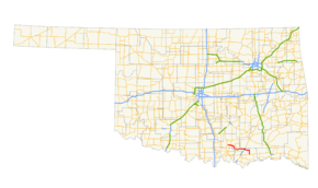
→State Highway 22 (SH-22 or OK-22) is a state highway in Oklahoma. It runs in a 47.5-mile[1] (76 km) west-to-east pattern through the south-central part of the state, running from SH-1 at Ravia to US-70 at Bokchito.
There are no letter-suffixed spur highways branching from SH-22.
Contents
Route description
SH-22 begins at SH-1 in the town of Ravia, in southern Johnston County. From there, it travels three miles (4.8 km) east to US-377/SH-99, where it joins with them in a one-mile (1.6 km) concurrency to Tishomingo.
In Tishomingo, SH-78 begins, concurrent with SH-22. The two highways run three miles (5 km) east before splitting off. SH-22 then turns roughly southeast and goes 13 miles (21 km) to its second concurrency with SH-78 at Nida (unincorporated).
From here, it runs seven miles (11.2 km) due east to the intersection of SH-48, just west of Kenefic, then seven more miles to the junction with US-69/US-75 outside Caddo.
From Caddo, SH-22 travels east, then south, 13 miles (27.3 km) to its terminus at US-70 in Bokchito, in eastern Bryan County.
History
ROUTE NO. 22 Beginning at Durant in Bryan county, at a connection with State Highways, No. 5 and 6, via Milburn, Tishomingo, Ravia, Mill Creek, Sulphur, and Davis, to a connection with State Highway No. 4.—Oklahoma State Highway Department, Official State Map, 1925 editionSH-22 once had a much longer route. When it was commissioned on August 4, 1924, it ran from Durant to Davis[2], the Ravia to Davis section being current SH-1 and SH-7. It ended at the original SH-4, current US-77.[3] In 1931, it was extended west to Ratliff City, where it ended at SH-29.[2] In 1932, SH-29 was given a new alignment to the north; SH-22 was reassigned to the old alignment.[4], extending it to Duncan.[2] On its other end, SH-22 was extended south from Durant, through Achille to a stub ending east of town.[4] In January 1933, it was extended further east, to the Donham Bridge over the Red River.[2][5]. On 1934-12-17, the highway was rerouted over a stretch of Farm-to-Market road between Tishomingo and Nida, bypassing Milburn.[2] This decision was reversed in 1935 (with the old alignment becoming SH-22S)[6] but redone in 1936.[2]
By 1939, SH-22 had been routed through Milburn once again. This time, however, the southern route became SH-299, which took over SH-22 between Nida and the state line. SH-22 was truncated once again on 1941-11-22, this time all the way to Ravia, the current western terminus of the route.[2] SH-22 and SH-299 swapped places yet again in 1946, with SH-22 once again taking the southern route.[2] In 1956, SH-22 was extended east to its current terminus at Bokchito.[2] Other than minor realignments, the highway in 1956 was the same as it is today.
Junction list
County Location Mile[1] Destinations Notes Johnston Ravia 0.0 SH-1Western terminus 3.3 
 US-377/SH-99
Tishomingo 4.4 US-377/SH-994.4  SH-78
SH-78Western terminus of SH-78 (begins duplexed with SH-22) 7.0 SH-78Nida 19.7 SH-7820.0 SH-78Bryan Kenefic 27.2  SH-48
SH-48Caddo 34.2 
 US-69/75
Diamond interchange[7] Bokchito 47.5 US-70Eastern terminus 1.000 mi = 1.609 km; 1.000 km = 0.621 mi References
- ^ a b Stuve, Eric. "OK-22". OKHighways. http://www.okhighways.com/ok22.html. Retrieved 2006-09-19.
- ^ a b c d e f g h i Oklahoma Department of Transportation, Planning & Research Division. "Memorial Dedication & Revision History - SH-22". http://www.okladot.state.ok.us/memorial/legal/sh22.htm. Retrieved 2007-05-08.
- ^ Oklahoma Department of Transportation. Official State Map (Map) (1925 ed.). http://www.okladot.state.ok.us/hqdiv/p-r-div/maps/state-maps/pdfs/1925route.pdf.
- ^ a b Oklahoma Department of Transportation. Official State Map (Map) (1932 ed.). http://www.okladot.state.ok.us/hqdiv/p-r-div/maps/state-maps/pdfs/1932.pdf.
- ^ Oklahoma Department of Transportation. Official State Map (Map) (1934 ed.). http://www.okladot.state.ok.us/hqdiv/p-r-div/maps/state-maps/pdfs/1934.pdf. Retrieved 2007-09-09.
- ^ Oklahoma Department of Transportation. Official State Map (Map) (1937 ed.). http://www.okladot.state.ok.us/hqdiv/p-r-div/maps/state-maps/pdfs/1937.pdf. Retrieved 2007-09-09.
- ^ Google, Inc. Google Maps – Oklahoma State Highway 22 (Map). Cartography by Google, Inc. http://maps.google.com/maps?f=q&hl=en&geocode=&q=caddo,+OK&ie=UTF8&ll=34.131842,-96.273537&spn=0.017051,0.037851&z=15&om=1. Retrieved 2007-09-10.
External links
Categories:- State highways in Oklahoma


Wikimedia Foundation. 2010.