- Oklahoma State Highway 23
-
State Highway 23
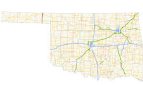
Route information Maintained by ODOT Length: 36.2 mi (58.3 km) Major junctions South end:  SH 23 at the Texas state line
North end:  K-23 at the Kansas state line
Highway system Oklahoma State Highways
Oklahoma turnpike system←  SH-22
SH-22SH-24  →
→State Highway 23 (SH-23 or OK-23) is a state highway in Oklahoma. It runs 36.2 miles[1] south-to-north through the center of Beaver County, in the Panhandle, running from the Texas state line to the Kansas state line.
There are no letter-suffixed spur highways branching from SH-23.
Contents
Route description
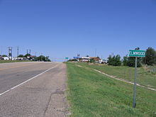 US-270/412/SH-3 meet SH-23 at Elmwood.
SH-23 begins at the Texas state line 3 miles (4.8 km) north of Booker, Texas. Upon entering Oklahoma, the highway makes a ninety degree turn to parallel the state line for approximately ½ mile (0.8 km), running just north of the line. It then turns back to the north and travels eight miles (13 km) due north to the intersection with US-270/US-412/SH-3, at the crossroads settlement of Elmwood. US-270 splits away from the other two highways at Elmwood, turning north to join SH-23.[2]
A little over one mile (1.8 km) north of Elmwood. US-270/SH-23 cross over Clear Creek, a tributary of the North Canadian River. The two highways enter Beaver, the county seat of Beaver County, about 13 miles (21 km) north of Elmwood. Just north of Beaver, the highway crosses the Beaver River (another name for this portion of the North Canadian River). After crossing the river, US-270 and SH-23 pass through Beaver Dunes State Park.[2]
Approximately six miles (10 km) north of Beaver, US-270 and SH-23 intersect US-64 and split up; US-270 turns west along US-64 towards Forgan, while SH-23 follows US-64 for about a mile eastbound. After splitting up, SH-23 turns due north, continuing to its terminus seven miles (11 km) later at the Kansas state line. North of the line it becomes K-23, which continues on to Meade, Kansas.[2]
History
Prior to SH-23's establishment, the highway carried two designations—US-270 followed the same portion of the route that it does today, and a segment of SH-15 connected Elmwood to the Texas state line.[3] (A connection with the current western terminus of SH-15 was made with what was then Farm to Market Road 1265[4] to Booker and TX-117 back to Oklahoma.[3]) The connection to Kansas north of US-64 did not exist as a state highway prior to 1957; it first appears on the 1958 state highway map, also signed as SH-15. The highway is not shown as overlapping US-64 and US-270 to Elmwood.[5]
SH-23 is first shown replacing SH-23 on the 1959 map, implying the change took place in 1958.[6] Again, SH-23 is not shown as overlapping US-270; it would not be shown as doing such until the 1975 edition.
K-23 was in existence as early as April 1940, shown with a spur ending north of the state line on Oklahoma's state map.[7] On December 11, 1959, the Kansas and Oklahoma highway commissions held a joint meeting in Wichita, Kansas. At that meeting, the Kansas Highway Commission resolved to connect K-23 with OK-23 to establish a "route number...common to both states."[8] K-23 was already shown on the Oklahoma highway map connecting to Oklahoma's SH-23 as early as the 1957 edition.[9]
Similarly, the Texas Highway Commission ordered its State Highway 23 signed on January 25, 1959, alongside existing FM 1265. The highway, however, officially remained part of FM 1265 until December 18, 1990, when TX-23 was officially established and FM 1265 cancelled.[4]
Junction list
County Location Mile[1] Destinations Notes Beaver 0.0 TX-23Southern terminus, Texas state line Elmwood 8.4 

 US-270/US-412/SH-3
US-270 joins northbound and splits southbound 28.7  US-64/US-270
US-64 joins northbound and splits southbound, US-270 splits northbound and joins southbound 29.7 US-64US-64 splits northbound and joins southbound 36.2 K-23Northern terminus, Kansas state line 1.000 mi = 1.609 km; 1.000 km = 0.621 mi References
- ^ a b Stuve, Eric. "OK-23". OKHighways. http://www.okhighways.com/ok23.html. Retrieved 2006-09-19.
- ^ a b c DeLorme (2006). Oklahoma Atlas and Gazetteer (Map). 1:200,000. p. 17.
- ^ a b Oklahoma Department of Highways (1953). Highways of Oklahoma (Map). http://www.odot.org/hqdiv/p-r-div/maps/state-maps/pdfs/1953.pdf. Retrieved 2010-02-25.
- ^ a b Texas Department of Transportation. "Highway Designation File: State Highway No. 23". http://www.dot.state.tx.us/tpp/hwy/sh/sh0023.htm. Retrieved 2010-02-25.
- ^ Oklahoma Department of Highways. 1958 Oklahoma Road Map (Map). http://www.odot.org/hqdiv/p-r-div/maps/state-maps/pdfs/1958.pdf. Retrieved 2010-02-25.
- ^ Oklahoma Department of Highways. 1959 Oklahoma Road Map (Map). http://www.odot.org/hqdiv/p-r-div/maps/state-maps/pdfs/1958.pdf. Retrieved 2010-02-25.
- ^ Oklahoma Department of Highways. Map Showing Condition of Improvement of the State Highway System (Map) (April 1940 ed.). http://www.odot.org/hqdiv/p-r-div/maps/state-maps/pdfs/1940.pdf. Retrieved 2010-02-25.
- ^ Oklahoma Department of Highways. "Highway Routing and Numbering Notes From Joint Meeting, Oklahoma and Kansas Highway Commissions at Wichita, Kansas on Friday, December 11, 1959". US-56 Highway Commission Action 1 data, page 11. Accessed 2009-03-17.
- ^ Oklahoma Department of Highways. Oklahoma's Highways 1957 (Map). http://www.odot.org/hqdiv/p-r-div/maps/state-maps/pdfs/1957.pdf. Retrieved 2010-02-25.
External links
Categories:- State highways in Oklahoma


Wikimedia Foundation. 2010.