- Meade, Kansas
-
Meade, Kansas — City — Location of Meade, Kansas
Coordinates: 37°17′10″N 100°20′21″W / 37.28611°N 100.33917°WCoordinates: 37°17′10″N 100°20′21″W / 37.28611°N 100.33917°W Country United States State Kansas County Meade Area - Total 1.0 sq mi (2.5 km2) - Land 1.0 sq mi (2.5 km2) - Water 0.0 sq mi (0.0 km2) Elevation 2,497 ft (761 m) Population (2010)[1] - Total 1,721 - Density 1,721/sq mi (664.5/km2) Time zone Central (CST) (UTC-6) - Summer (DST) CDT (UTC-5) ZIP code 67864 Area code(s) 620 FIPS code 20-45325[2] GNIS feature ID 0470596[3] Website CityOfMeade.org Meade is a city in and the county seat of Meade County, Kansas, United States.[4] As of the 2010 census, the city population was 1,721.[1]
Contents
History
In August, 2006, the town received national media attention due to the reaction after a rainbow flag was flown above a local hotel.[5]
Geography
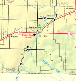
Meade is located at 37°17′10″N 100°20′21″W / 37.28611°N 100.33917°W (37.286107, -100.339300)[6]. According to the United States Census Bureau, the city has a total area of 1.0 square mile (2.6 km2), all of it land.
Area attraction
Located in Meade is the former hideout of the Dalton Gang, who robbed banks and trains in the nineteenth century.[7]
Demographics
Historical populations Census Pop. %± 1990 1,526 — 2000 1,672 9.6% 2010 1,721 2.9% U.S. Decennial Census As of the census[2] of 2000, there were 1,672 people, 654 households, and 451 families residing in the city. The population density was 1,739.2 people per square mile (672.5/km²). There were 753 housing units at an average density of 783.2 per square mile (302.8/km²). The racial makeup of the city was 94.20% White, 0.60% African American, 0.48% Native American, 0.42% Asian, 3.23% from other races, and 1.08% from two or more races. Hispanic or Latino of any race were 5.56% of the population.
There were 654 households out of which 33.2% had children under the age of 18 living with them, 60.6% were married couples living together, 5.7% had a female householder with no husband present, and 31.0% were non-families. 29.4% of all households were made up of individuals and 17.7% had someone living alone who was 65 years of age or older. The average household size was 2.44 and the average family size was 3.03.
In the city the population was spread out with 26.7% under the age of 18, 5.9% from 18 to 24, 25.7% from 25 to 44, 19.4% from 45 to 64, and 22.2% who were 65 years of age or older. The median age was 40 years. For every 100 females there were 91.5 males. For every 100 females age 18 and over, there were 89.6 males.
The median income for a household in the city was $32,583, and the median income for a family was $40,357. Males had a median income of $27,813 versus $20,764 for females. The per capita income for the city was $15,910. About 3.9% of families and 5.7% of the population were below the poverty line, including 4.6% of those under age 18 and 8.3% of those age 65 or over.
References
- ^ a b "2010 City Population and Housing Occupancy Status". U.S. Census Bureau. http://factfinder2.census.gov/faces/tableservices/jsf/pages/productview.xhtml?pid=DEC_10_PL_GCTPL2.ST13&prodType=table. Retrieved March 27, 2011.
- ^ a b "American FactFinder". United States Census Bureau. http://factfinder.census.gov. Retrieved 2008-01-31.
- ^ "US Board on Geographic Names". United States Geological Survey. 2007-10-25. http://geonames.usgs.gov. Retrieved 2008-01-31.
- ^ "Find a County". National Association of Counties. http://www.naco.org/Counties/Pages/FindACounty.aspx. Retrieved 2011-06-07.
- ^ "Over the Rainbow" Weekend America, August 19, 2006.
- ^ "US Gazetteer files: 2010, 2000, and 1990". United States Census Bureau. 2011-02-12. http://www.census.gov/geo/www/gazetteer/gazette.html. Retrieved 2011-04-23.
- ^ http://www.oldmeadecounty.com/hideout.htm
Further reading
- History of the State of Kansas; William G. Cutler; A.T. Andreas Publisher; 1883. (Online HTML eBook)
- Kansas : A Cyclopedia of State History, Embracing Events, Institutions, Industries, Counties, Cities, Towns, Prominent Persons, Etc; 3 Volumes; Frank W. Blackmar; Standard Publishing Co; 944 / 955 / 824 pages; 1912. (Volume1 - Download 54MB PDF eBook),(Volume2 - Download 53MB PDF eBook), (Volume3 - Download 33MB PDF eBook)
External links
- City
- City of Meade
- Meade - Directory of Public Officials
- Meade Economic Development
- Meade Chamber of Commerce
- Schools
- USD 226, local school district
- Historical
- Maps
- Meade City Map, KDOT
- Meade County Map, KDOT
Municipalities and communities of Meade County, Kansas Cities 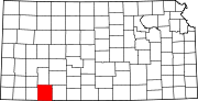 Categories:
- Cities in Kansas
- County seats in Kansas
- Populated places in Meade County, Kansas


Wikimedia Foundation. 2010.