- Cooperton, Oklahoma
-
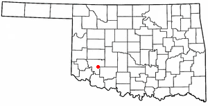
Cooperton, Oklahoma — Town — Location of Cooperton, Oklahoma
Coordinates: 34°51′58″N 98°52′12″W / 34.86611°N 98.87°WCoordinates: 34°51′58″N 98°52′12″W / 34.86611°N 98.87°W Country United States State Oklahoma County Kiowa Area – Total 0.5 sq mi (1.3 km2) – Land 0.5 sq mi (1.3 km2) – Water 0.0 sq mi (0.0 km2) Elevation 1,555 ft (474 m) Population (2000) – Total 20 – Density 40.8/sq mi (15.8/km2) Time zone Central (CST) (UTC-6) – Summer (DST) CDT (UTC-5) FIPS code 40-17050[1] GNIS feature ID 1091677[2] Cooperton is a town in Kiowa County, Oklahoma, United States. The population was 20 at the 2000 census.
Contents
Geography
Cooperton is located at 34°51′58″N 98°52′12″W / 34.86611°N 98.87°W (34.866001, -98.870026)[3].
According to the United States Census Bureau, the town has a total area of 0.5 square miles (1.3 km2), all of it land.
Demographics
As of the census[1] of 2000, there were 20 people, 12 households, and 6 families residing in the town. The population density was 40.8 people per square mile (15.8/km²). There were 19 housing units at an average density of 38.8 per square mile (15.0/km²). The racial makeup of the town was 85.00% White and 15.00% African American.
There were 12 households out of which 16.7% had children under the age of 18 living with them, 41.7% were married couples living together, and 50.0% were non-families. 50.0% of all households were made up of individuals and 33.3% had someone living alone who was 65 years of age or older. The average household size was 1.67 and the average family size was 2.33.
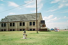 The Cooperton Baptist church is one of the most substantial buildings remaining in this small town.
In the town the population was spread out with 15.0% under the age of 18, 20.0% from 25 to 44, 20.0% from 45 to 64, and 45.0% who were 65 years of age or older. The median age was 64 years. For every 100 females there were 300.0 males. For every 100 females age 18 and over, there were 240.0 males.
The median income for a household in the town was $13,125, and the median income for a family was $14,375. Males had a median income of $11,875 versus $0 for females. The per capita income for the town was $12,096. There are 28.6% of families living below the poverty line and 35.7% of the population, including 60.0% of under eighteens and 22.2% of those over 64.
References
- ^ a b "American FactFinder". United States Census Bureau. http://factfinder.census.gov. Retrieved 2008-01-31.
- ^ "US Board on Geographic Names". United States Geological Survey. 2007-10-25. http://geonames.usgs.gov. Retrieved 2008-01-31.
- ^ "US Gazetteer files: 2010, 2000, and 1990". United States Census Bureau. 2011-02-12. http://www.census.gov/geo/www/gazetteer/gazette.html. Retrieved 2011-04-23.
External links
- Cooperton at GhostTowns.com
- Encyclopedia of Oklahoma History and Culture - Cooperton
Municipalities and communities of Kiowa County, Oklahoma City 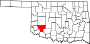
Towns Cooperton | Gotebo | Lone Wolf | Mountain Park | Mountain View | Roosevelt | Snyder
Unincorporated
communitiesBabbs | Lugert | Saddle Mountain | Sedan
Categories:- Populated places in Kiowa County, Oklahoma
- Towns in Oklahoma


Wikimedia Foundation. 2010.