- Checotah, Oklahoma
-
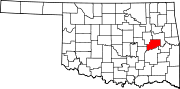
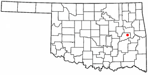
Checotah, Oklahoma — City — Kniseley and Long Building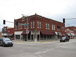 Location of Checotah, Oklahoma
Coordinates: 35°28′19″N 95°31′26″W / 35.47194°N 95.52389°WCoordinates: 35°28′19″N 95°31′26″W / 35.47194°N 95.52389°W Country United States State Oklahoma County McIntosh Area - Total 9.0 sq mi (23.3 km2) - Land 8.9 sq mi (23.2 km2) - Water 0.1 sq mi (0.2 km2) Elevation 650 ft (198 m) Population (2000) - Total 3,481 - Density 389.3/sq mi (150.3/km2) Time zone Central (CST) (UTC-6) - Summer (DST) CDT (UTC-5) ZIP code 74426 Area code(s) 539/918 FIPS code 40-13650[1] GNIS feature ID 1091227[2] Checotah is a city in McIntosh County, Oklahoma, United States. It was named for Samuel Checote, the first chief of the Creek Nation elected after the Civil War.[3] The population was 3,481 at the 2000 census.
Checotah is home to numerous antique malls, a Civil War battle site and a downtown historic district. Checotah claims to be the steer wrestling capital of the world[4]. The telephone area code is 539/918 and the postal ZIP code is 74426.
Contents
Geography
Checotah is located at an elevation of 652 feet (199 m) at the intersection of I-40 and U.S. Route 69. Nearby is Eufaula Lake, which was once the largest man-made lake in the nation, with 640 miles (1,030 km) of shoreline.
According to the United States Census Bureau, the city has a total area of 9.0 sq mi (23 km2). 8.9 square miles (23 km2) of it is land and 0.1 square miles (0.26 km2) of it (0.67%) is water.
Demographics
As of the census[1] of 2000, there were 3,481 people, 1,389 households, and 912 families residing in the city. The population density was 389.3 per square mile (150.3/km²). There were 1,576 housing units at an average density of 176.3 per square mile (68.1/km²). The racial makeup of the city was 67.91% White, 6.92% African American, 15.91% Native American, 0.23% Asian, 0.09% Pacific Islander, 0.40% from other races, and 8.53% from two or more races. Hispanic or Latino of any race were 1.29% of the population.
There were 1,389 households out of which 31.5% had children under the age of 18 living with them, 44.9% were married couples living together, 17.7% had a female householder with no husband present, and 34.3% were non-families. 31.5% of all households were made up of individuals and 18.4% had someone living alone who was 65 years of age or older. The average household size was 2.39 and the average family size was 2.98.
In the city the population was spread out with 26.1% under the age of 18, 8.2% from 18 to 24, 23.7% from 25 to 44, 20.3% from 45 to 64, and 21.7% who were 65 years of age or older. The median age was 39 years. For every 100 females there were 77.7 males. For every 100 females age 18 and over, there were 72.5 males.
The median income for a household in the city was $22,029, and the median income for a family was $30,741. Males had a median income of $26,094 versus $17,298 for females. The per capita income for the city was $15,921. About 16.1% of families and 20.4% of the population were below the poverty line, including 23.4% of those under age 18 and 7.6% of those age 65 or over. The median house value is $50,500.
Popular culture
- American Idol Season 4 winner Carrie Underwood wrote a song on her album Some Hearts called "I Ain't in Checotah Anymore". It includes references to the local high school team (Wildcats), Highways 69 and 40, the Okra Fest, and Lake Eufaula.
Notable citizens
- Paul H. Carr - Silver Star recipient
- Woody Crumbo, Native American artist, lived and worked in Checotah during the later part of his career.[5]
- Jim G. Lucas (1914–1970), Pulitzer Prize-winning war correspondent.
- Mel McDaniel, country musician
- Carrie Underwood, country musician
References
- ^ a b "American FactFinder". United States Census Bureau. http://factfinder.census.gov. Retrieved 2008-01-31.
- ^ "US Board on Geographic Names". United States Geological Survey. 2007-10-25. http://geonames.usgs.gov. Retrieved 2008-01-31.
- ^ Chronicles of Oklahoma chapter on Chief Checote. Accessed September 24, 2011.
- ^ M. Bergstrom. "Checotah is Steer Wrestling Capital of the World". American Profile. Publishing Group of America, Inc.. http://www.americanprofile.com/articles/checotah-is-steer-wrestling-capital-of-the-world/. Retrieved 18 September 2011.
- ^ Hunt, David C. Crumbo, Woodrow Wilson (1912-1989) at Oklahoma Historical Society Encyclopedia of Oklahoma History and Culture (retrieved November 18, 2009).
External links
- Official website
- Checotah High School
- Checotah at City-Data.com
- Encyclopedia of Oklahoma History and Culture - Checotah
Municipalities and communities of McIntosh County, Oklahoma Cities Checotah | Eufaula
Towns Hanna | Hitchita | Rentiesville | Stidham
CDPs Unincorporated
communitiesBond | Brush Hill | Fame | Lenna | Mellette | Onapa | Pierce | Shady Grove | Texanna | Vernon | Vivian
Categories:- Populated places in McIntosh County, Oklahoma
- Cities in Oklahoma


Wikimedia Foundation. 2010.