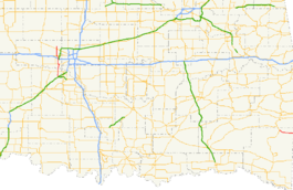
- Oklahoma State Highway 4
-
"OK 4" redirects here. OK 4 may also refer to Oklahoma's 4th congressional district.
State Highway 4
Route information Maintained by ODOT History: 1941–present (western SH-4)[1]
1963–present (eastern SH-4)[2]Section 1 Length: 29.5 mi[3] (47.5 km) South end:  I-44/H.E. Bailey Turnpike south of Bridge Creek
North end: Piedmont Section 2 Length: 12.01 mi[4] (19.33 km) West end:  US-259 in Smithville
East end:  AR-4 at the Arkansas state line
Highway system Oklahoma State Highways
Oklahoma turnpike system←  SH-3
SH-3SH-5  →
→State Highway 4, abbreviated as SH-4 or OK-4, is a designation for two distinct highways maintained by the U.S. state of Oklahoma. One of them serves as an important route through the suburbs west of Oklahoma City, while the other connects US-259 to the Arkansas state line west of Cove, Arkansas. SH-4 has no lettered spur routes
The two SH-4s were never connected. The Central Oklahoma highway was established in 1941 and gradually extended to its present extent between then and 2003. The Eastern Oklahoma highway was originally numbered SH-21, and was renumbered to SH-4 in 1963.
Contents
Route description
Central Oklahoma
 The northern end of SH-4 in Piedmont.
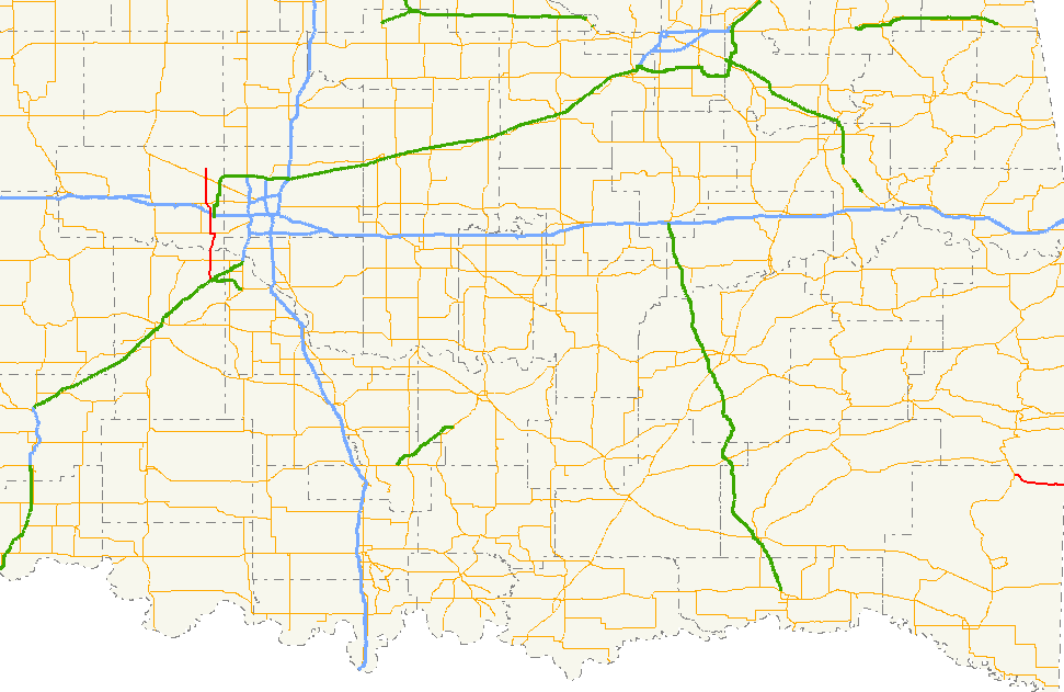
The western Highway 4 is 29.5 miles (47.5 km) long.[3] It begins at the western terminus of the H.E. Bailey Turnpike Spur south of Bridge Creek, Oklahoma, and immediately curves due north. It is a two-lane road until it reaches SH-37, where it expands to four lanes. Seven miles (11.2 km) later, it joins with SH-152 in the town of Mustang.[5] One mile (1.66 km) later, SH-4 continues northward along Mustang Road toward Interstate 40 and Yukon.[5]
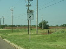
After crossing I-40, SH-4 becomes a two-lane road once again until entering Yukon, at which point it becomes a four-lane road again. It meets SH-66, once Route 66, in Yukon. Seven miles (11.2 km) later, it meets the Northwest Expressway (SH-3).[5] It lasts for just three miles (4.8 km) longer until ending at Edmond Road in Piedmont.[5]
Just after crossing SH-3, there is a standard distance sign listing Piedmont and "END OF ROUTE", giving the distance to the terminus of SH-4. This is a relative rarity on Oklahoma highways.
Eastern Oklahoma
The eastern Highway 4 is 12.01 miles (19.33 km) long.[4] It begins at US-259 and goes generally east–west, passing through the unincorporated communities of Smithville and Watson. After crossing the Arkansas state line, it becomes Highway 4.
History
Central Oklahoma
The western SH-4 was assigned in 1941 to a previously unnumbered roadway between U.S. Highway 66 in Yukon and Piedmont.[1][6] A continuation of SH-4 east to North May Avenue in Oklahoma City along Ranchwood Boulevard and NW 10th Street had been designated as a farm-to-market road four years earlier.[7][8] In 1954, SH-4 was extended eastward along the farm-to-market road to a terminus at State Highway 3 and State Highway 74 (May Avenue) southwest of downtown Oklahoma City.[9][10]
SH-4 remained unchanged until 1979 when it was truncated to its former southern terminus at US-66 in Yukon.[11] The route was then extended to Mustang in 1982, following Ranchwood Boulevard and Mustang Road south to a new terminus at State Highway 152.[12] Construction on a southward extension of SH-4 to State Highway 37 near Tuttle began in 2001[13] and was completed a year later, as was a new segment between SH-37 and the H.E. Bailey Turnpike (Interstate 44).[14] SH-4 was originally signed only as far south as SH-37; the designation was extended south to I-44 in early 2003.[3]
Eastern Oklahoma
What is now the eastern SH-4 became part of State Highway 21 in 1927 when SH-21 was rerouted north of Bethel to follow modern U.S. Highway 259 and SH-4 to the Arkansas state line.[15][16] The SH-21 designation was removed in 1963 and replaced with SH-4 from Smithville east to the state line near Watson. Only minor realignments, such as the straightening of the roadway near Smithville and the replacement of a historic truss bridge by a modern span have occurred since.[2]
Junction list
Central Oklahoma
County Location Mile[3] Destinations Notes Grady Bridge Creek 0.0 I-44 / H.E. Bailey TurnpikeTuttle 4.0  SH-37
SH-37Canadian Mustang 9.6  SH-152 east
Eastern terminus of concurrency 10.6 SH-152 westWestern terminus of concurrency Yukon 16.1 
 I-40 / US-270
19.2  SH-66 east
Eastern terminus of concurrency 19.5 SH-66 westWestern terminus of concurrency Piedmont 26.2 SH-329.5 Edmond Road 1.000 mi = 1.609 km; 1.000 km = 0.621 mi
Concurrency terminus • Closed/Former • Incomplete access • UnopenedEastern Oklahoma
County Location Mile[4] Destinations Notes McCurtain Smithville 0.00 US-259Western terminus East of Watson 12.01 Hwy. 4Eastern terminus, Arkansas state line 1.000 mi = 1.609 km; 1.000 km = 0.621 mi References
- ^ a b Oklahoma Department of Highways (1941). Map Showing Condition of Improvement of the State Highway System (Map). http://www.odot.org/hqdiv/p-r-div/maps/state-maps/pdfs/1941.pdf. Retrieved 2007-12-07.
- ^ a b Oklahoma Department of Highways (1963). Oklahoma (Map). http://www.odot.org/hqdiv/p-r-div/maps/state-maps/pdfs/1963.pdf. Retrieved 2007-12-07.
- ^ a b c d "OKHighways.com - OK 4 (West)". http://okhighways.com/ok4w.html. Retrieved 2007-12-07.
- ^ a b c Oklahoma Department of Transportation. 2008 Control Section Maps – McCurtain County (Map). http://www.odot.org/hqdiv/p-r-div/maps/control-maps/mccurtain.pdf. Retrieved 2010-06-28.
- ^ a b c d Oklahoma Department of Transportation. Official State Map (Map) (2009–10 ed.). http://www.odot.org/hqdiv/p-r-div/maps/state-maps/2009state/pdfs/state-map.pdf. Retrieved 2010-06-29.
- ^ Oklahoma Department of Highways (1940). Map Showing Condition of Improvement of the State Highway System (Map). http://www.odot.org/hqdiv/p-r-div/maps/state-maps/pdfs/1940.pdf. Retrieved 2007-12-07.
- ^ Oklahoma Department of Highways (1936). Map Showing Condition of Improvement of the State Highway System and Landing Fields (Map). http://www.odot.org/hqdiv/p-r-div/maps/state-maps/pdfs/1936.pdf. Retrieved 2007-12-07.
- ^ Oklahoma Department of Highways (1937). Map Showing Condition of Improvement of the State Highway System (Map). http://www.odot.org/hqdiv/p-r-div/maps/state-maps/pdfs/1937.pdf. Retrieved 2007-12-07.
- ^ Oklahoma Department of Highways (1954). Highways of Oklahoma (Map). http://www.odot.org/hqdiv/p-r-div/maps/state-maps/pdfs/1954.pdf. Retrieved 2007-12-07.
- ^ Oklahoma Department of Highways (1954). Highways of Oklahoma (back side) (Map). http://www.odot.org/hqdiv/p-r-div/maps/state-maps/pdfs/1954b.pdf. Retrieved 2007-12-07.
- ^ Oklahoma Department of Transportation (1979). Official State Map (Map). http://www.odot.org/hqdiv/p-r-div/maps/state-maps/pdfs/1979.pdf. Retrieved 2007-12-07.
- ^ Oklahoma Department of Transportation (1982). Official State Map (Map). http://www.odot.org/hqdiv/p-r-div/maps/state-maps/pdfs/1982.pdf. Retrieved 2007-12-07.
- ^ Oklahoma Department of Transportation. Official State Map (Map) (2001-2002 ed.). http://www.odot.org/hqdiv/p-r-div/maps/state-maps/pdfs/2001-02.pdf. Retrieved 2007-12-07.
- ^ Rand McNally (2002). The Road Atlas - Large Scale - United States (Map). p. 168, section G13.
- ^ Oklahoma Department of Highways (1926). Oklahoma State Highway System (Map). http://www.odot.org/hqdiv/p-r-div/maps/state-maps/pdfs/1926.pdf. Retrieved 2007-12-07.
- ^ Oklahoma Department of Highways (1927). Oklahoma State Highway System (Map). http://www.odot.org/hqdiv/p-r-div/maps/state-maps/pdfs/1927.pdf. Retrieved 2007-12-07.
External links
Categories:- State highways in Oklahoma
- Transportation in Oklahoma City, Oklahoma


Wikimedia Foundation. 2010.