- Oklahoma State Highway 37
-
State Highway 37
Route information Maintained by ODOT Section 1 Length: 67.1 mi (108.0 km) West end: 
 US-281/SH-8 in Hinton
East end: Sunnylane Road in Moore Section 2 Length: 12.6 mi (20.3 km) West end:  SH 37 at the Texas state line
East end: 
 US-70 Byp. in Idabel
Highway system Oklahoma State Highways
Oklahoma turnpike system←  SH-36
SH-36SH-38  →
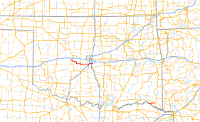
→State Highway 37 (SH-37 or OK-37) is a designation for two separate highways in the state of Oklahoma. The northern section runs between Hinton and Moore in central Oklahoma, while the southern section runs from the Texas state line at the Red River to Idabel, in southeastern Oklahoma. The northern section of SH-37 runs 67.1[1] miles from US-281 in Hinton to Sunnylane Road (former SH-77H) in Moore. The southern section of SH-37 is 12.6 miles (20.3 km) long.[2]
Contents
Route descriptions
Central Oklahoma
The SH-37 in Central Oklahoma begins at US-281 in Hinton, Caddo County. It runs in a zigzag pattern for four miles (6 km) to the southeast before crossing into Canadian County.[3] The Canadian County section runs in an irregular path to the southeast for 14 miles (23 km), before re-entering Caddo County.[4]
Back in Caddo County, SH-37 runs three miles (5 km) south to the town of Cogar, where it joins SH-152, and turns to the east. This concurrency goes two miles (3 km) before entering Grady County.
In Grady County, SH-37/SH-152 goes 8.8 miles (14.2 km) to the east to US-81. There SH-152 turns to the north, and SH-37 joins US-81 for a one-and-a-half mile concurrency to Minco, where SH-37 splits off and heads east once again.
SH-37 runs for 16.6 miles (26.7 km) in Grady County, serving as the northern terminus for SH-92 on the west edge of Tuttle, and intersecting SH-4 in Tuttle before crossing into McClain County.[5]
One mile into McClain County, SH-37 serves as the northern terminus for SH-76, then joins I-44 for a brief concurrency three miles later.[6] SH-37 overlaps I-44 for three miles (5 km), running north across the Canadian River into Cleveland County and Oklahoma City, where it runs east along SW 134th Street into the city of Moore, where it becomes S. 4th Street.[7]
SH-37 ends at Sunnylane Road, formerly SH-77H, in Moore.
Southeastern Oklahoma
The southeastern SH-37 begins where TX-37 crosses the Red River into Oklahoma, and heads north for two miles (3 km) to a junction with SH-98. At this point, SH-37 heads east for 10½ miles to its terminus at US-70 Bypass in Idabel.[8]
History
Central Oklahoma
Southeastern Oklahoma
The southeastern SH-37 was originally numbered as SH-57.
Spurs
Junction lists
Central Oklahoma
County Location Mile[1] Destinations Notes Caddo Hinton 0.0 US-281/SH-8Western terminus Canadian No major junctions Caddo Cogar 21.2  SH-152
Western end of SH-152 concurrency Grady 31.9  US-81/SH-152
Eastern end of SH-152 concurrency, northern end of US-81 concurrency Minco 33.5 US-81Southern end of US-81 concurrency Tuttle 41.7  SH-92
SH-92Northern terminus of SH-92 47.0  SH-4
SH-4McClain Newcastle 51.0  SH-76
SH-76Northern terminus of SH-76 54.4  I-44
I-44Interchange, I-44 exit 108, Southern end of I-44 concurrency Cleveland Oklahoma City 56.9 I-44Interchange, I-44 exit 110, Northern end of I-44 concurrency Moore 62.8  I-35
I-35Interchange, I-35 exit 117 65.6 Sunnylane Road Eastern terminus 1.000 mi = 1.609 km; 1.000 km = 0.621 mi
Concurrency terminus • Closed/Former • Incomplete access • UnopenedSoutheastern Oklahoma
County Location Mile[2] Destinations Notes McCurtain 0.0 TX-37Western terminus, Texas state line 12.6
US-70 BYPEastern terminus 1.000 mi = 1.609 km; 1.000 km = 0.621 mi References
- ^ a b Stuve, Eric. "OK-37n". OKHighways. http://www.okhighways.com/ok37n.html. Retrieved 2006-09-20.
- ^ a b Stuve, Eric. "OK-37s". OKHighways. http://www.okhighways.com/ok37s.html. Retrieved 2006-09-20.
- ^ Oklahoma Department of Transportation. Caddo County. ODOT 2006 Control Section Maps. URL accessed 20 September 2006.
- ^ Oklahoma Department of Transportation. Canadian County. ODOT 2006 Control Section Maps. URL accessed 20 September 2006.
- ^ Oklahoma Department of Transportation. Grady County. ODOT 2006 Control Section Maps. URL accessed 20 September 2006.
- ^ Oklahoma Department of Transportation. McClain County. ODOT 2006 Control Section Maps. URL accessed 20 September 2006.
- ^ Oklahoma Department of Transportation. Cleveland County. ODOT 2006 Control Section Maps. URL accessed 20 September 2006.
- ^ Oklahoma Department of Transportation. McCurtain County. ODOT 2006 Control Section Maps. URL accessed 20 September 2006.
External links
Categories:- State highways in Oklahoma
- Transportation in Oklahoma City, Oklahoma


Wikimedia Foundation. 2010.