- U.S. Route 18
-
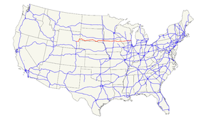
U.S. Route 18
Route information Length: 1,043 mi[1] (1,679 km) Existed: 1926[1] – present Major junctions West end: 


 US 20 / I-25 / US 26 / US 87 at Orin, WY
 I-29 near Worthing, SD
 I-35 at Clear Lake, IA

 I-39 / I-90 at Madison, WI
 I-94 at Waukesha, WI
 I-43 at Milwaukee, WI
East end: Lincoln Memorial Drive in Milwaukee, WI Highway system United States Numbered Highways
List • Bannered • Divided • ReplacedU.S. Route 18 (US 18) is an east–west U.S. highway in the Midwestern United States. The western terminus is in Orin, Wyoming at an interchange with Interstate 25. Its eastern terminus of US 18 is in downtown Milwaukee, Wisconsin.[2] However, US 18 runs concurrent with other U.S. routes from its western terminus to Mule Creek Junction, Wyoming.
US 18 is one of the original United States highways of 1926. The US 18 designation was originally proposed for a road in Michigan from Grand Haven east to Detroit. This roadway was eventually designated as U.S. Route 16.
Contents
Route description
Wyoming
In Wyoming, US 18 runs concurrent with U.S. Highway 20 from Interstate 25 to Lusk, where US 18 branches off to run concurrently with U.S. Highway 85. At the unincorporated community of Mule Creek Junction in northeastern Niobrara County, US 18 leaves US 85. This ten-mile (16 km) stretch from US 85 to the South Dakota border is the only segment of US 18 in Wyoming which is not co-signed with another highway.
South Dakota
U.S. 18 enters South Dakota west of Edgemont. It passes through Hot Springs, the Pine Ridge Indian Reservation, the Rosebud Indian Reservation, Winner, and Gregory before crossing the Missouri River near Pickstown over the Fort Randall Dam. East of the Missouri River, U.S. 18 passes through (or near) Lake Andes and Tripp before a brief concurrency with Interstate 29 near Worthing. East of I-29, U.S. 18 passes through Canton before crossing the Big Sioux River into Iowa.
The Oyate Trail is one of the names given (in the late 1990s) to US-18 traveling across South Dakota from I-29 east of Vermillion to Maverick Junction.[3]
Named in an attempt to encourage more tourism traffic through the lands of various AmerInd tribes in southern South Dakota, it passes through or near the Yankton Sioux Indian Reservation, the Rosebud Indian Reservation, and the Pine Ridge Indian Reservation, crossing the James River Valley, the Missouri River near Fort Randall Dam, portions of Pine Ridge, and the High Plains of South Dakota, connecting the urban areas of the middle Missouri River with the Black Hills.
Portions of the road were known as the Grant Highway, Black Hills Sioux Trail, and as part of the Omaha, Rosebud and Black Hills Highway and the Custer Battlefield Trail.
Towns along the road include Gregory, South Dakota, Winner, South Dakota, Mission, South Dakota, Martin, South Dakota, Batesland, South Dakota, and Pine Ridge, South Dakota. Nearby towns and locales of interest include Rosebud, South Dakota (capital of the Rosebud Sioux Tribe), and Wounded Knee, South Dakota.
Legal definition
The South Dakota section of U.S. 18, other than the concurrency with Interstate 29, is defined at South Dakota Codified Laws § 31-4-141.[4]
Iowa
U.S. 18 enters Iowa via a Big Sioux River crossing northeast of Beloit. It overlaps U.S. Route 75 for a mile near Hull and U.S. Route 59 for a mile near Sanborn. It then overlaps U.S. Route 71 through Spencer. U.S. 18 passes through Emmetsburg before intersecting U.S. Route 169 at Algona. U.S. 18 then continues east through Garner before intersecting Interstate 35 in Clear Lake. After a brief concurrency with I-35, U.S. 18 continues as a freeway bypassing Mason City to the south. At Charles City, U.S. 18 becomes a rural two-lane highway again, except for a brief concurrency with the U.S. Route 63 bypass of New Hampton. After passing through West Union, it turns northeast and joins U.S. Route 52 at Postville, then leaving 52 about 7 miles (11 km) east of Monona before crossing the Mississippi River into Wisconsin via the Marquette-Joliet Bridge in the city of Marquette.
U.S. 18 is the designated route of the Avenue of the Saints between Clear Lake and Charles City.
Wisconsin
Main article: U.S. Route 18 in WisconsinUpon entry into Wisconsin at Prairie du Chien, US 18 is the terminus for WIS 60. The two routes are then concurrent until Bridgeport where WIS 60 splits off to the east and US 18 crosses the Wisconsin River and turns east on the other side. The route joins the US 151 expressway in Dodgeville and the two remain concurrent east to Madison (See U.S. Route 151 in Wisconsin for an interchange list). US 18 follows US 12 south of Madison and passes through or around Cambridge, Jefferson and Waukesha before terminating in Milwaukee at the junction of East Michigan Street and Lincoln Memorial Drive in downtown.
Major intersections
- Interstate 25 at Orin, Wyoming
- U.S. Route 20 concurrency between Orin and Lusk, Wyoming
- U.S. Route 85 concurrency in Niobrara County, Wyoming
- U.S. Route 385 concurrency between Hot Springs and Oelrichs, South Dakota
- U.S. Route 83 concurrency near Mission, South Dakota
- U.S. Route 183 concurrency near Colome, South Dakota
- U.S. Route 281 concurrency through the Yankton Indian Reservation
- U.S. Route 81 in Hutchinson County, South Dakota
- Interstate 29 concurrency west of Canton, South Dakota
- U.S. Route 75 concurrency west of Hull, Iowa
- U.S. Route 59 concurrency near Sanborn, Iowa
- U.S. Route 71 concurrency near Spencer, Iowa
- U.S. Route 169 in Algona, Iowa
- U.S. Route 69 concurrency near Garner, Iowa
- Interstate 35 concurrency near Clear Lake, Iowa
- U.S. Route 65 south of Mason City, Iowa
- U.S. Route 218 concurrency between Floyd and Charles City, Iowa
- U.S. Route 63 concurrency between New Hampton and west of Fredericksburg, Iowa
- U.S. Route 52 concurrency between Postville and Froelich, Iowa
- U.S. Route 61 concurrency in Fennimore, Wisconsin
- U.S. Route 151 concurrency between Dodgeville and Madison, Wisconsin
- U.S. Route 12 concurrency between Madison and Cambridge, Wisconsin
- U.S. Route 14 concurrency in Madison
- U.S. Route 51 in Madison
- Interstate 39 and Interstate 90 in Madison
- Interstate 94 in Waukesha, Wisconsin
- U.S. Route 45 in Wauwatosa, Wisconsin
- U.S. Route 41 in Milwaukee, Wisconsin
- Interstate 43 in Milwaukee
- Lincoln Memorial Drive at Lake Michigan in Milwaukee
See also
Bannered routes
- U.S. Route 18 Business in Mason City, Iowa
- U.S. Route 18 Business in Marquette and McGregor, Iowa
Related U.S. Routes
- U.S. Route 118
- U.S. Route 218 runs north and south. The parent and child meet in Charles City, Iowa.
References
 Main U.S. Routes
1 2 3 4 5 6 7 8 9 10 11 12 13 14 15 16 17 18 19 20 21 22 23 24 25 26 27 28 29 30 31 32 33 34 35 36 37 38 40 41 42 43 44 45 46 48 49 50 51 52 53 54 55 56 57 58 59 60 61 62 63 64 65 66 67 68 69 70 71 72 73 74 75 76 77 78 79 80 81 82 83 84 85 87 89 90 91 92 93 94 95 96 97 98 99 101 163 400 412 425 Lists U.S. Routes • Bannered • Divided • Bypassed Browse numbered routes ←  US 16
US 16WY US 20 →←  SD 17
SD 17SD SD 19  →
→←  Iowa 17
IA US 20  →
→←  WIS 17
WI WIS 19  →Categories:
- U.S. Highway System
- U.S. Highways in South Dakota
- U.S. Highways in Wisconsin
- U.S. Highways in Wyoming
- U.S. Route 18


Wikimedia Foundation. 2010.