- U.S. Route 53
-
U.S. Route 53
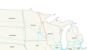
U.S. 53 highlighted in redRoute information Length: 403 mi[1] (649 km) Existed: 1926[1] – present Major junctions South end: 

 US 14 / US 61 / WIS 16
at La Crosse, WI I-90 at La Crosse, WI
 I-94 at Eau Claire, WI
 US 12 at Altoona, WI
 WIS 29 at Lake Hallie, WI
 US 63 at Spooner, WI
 US 2 at Superior, WI

 I-35 / I-535 at Duluth, MN
 MN 33 at Independence, MN

 US 169 / MN 169 at Virginia, MN
 US 71 / MN 11 at Int'l. Falls, MN
North end: 

 Highway 71 to Highway 11 / TCH
at Fort Frances, ONHighway system United States Numbered Highways
List • Bannered • Divided • Replaced←  WIS 52
WI WIS 53  →
→←  US 52
US 52MN MN 54  →
→U.S. Route 53 is a north–south U.S. highway that runs for 403 miles (649 km) from La Crosse, Wisconsin to northern Minnesota. It is the primary north–south route in northwestern Wisconsin, serving as a vital link between I-94 at Eau Claire, Wisconsin and the city of Duluth, Minnesota. The entire route from Eau Claire to the city limits of Superior, Wisconsin is a four lane divided highway. The highway's northern terminus is at the Fort Frances-International Falls Bridge in International Falls, Minnesota, at the U.S.-Canadian border. Its southern terminus is in La Crosse, Wisconsin, at U.S. Highway 14.
Contents
Route description
Wisconsin
U.S. Highway 53 begins at its southern terminus with a junction at U.S. 14, U.S. 61, and Wisconsin Highway 16 in downtown La Crosse. From there, U.S. 53 crosses Interstate 90 and becomes a freeway bypass of Onalaska and Holmen before proceeding north to Eau Claire as a two-lane roadway. The interchange with Interstate 94 at Eau Claire begins a freeway / expressway stretch for U.S. 53 north to the city limits of Superior. The recently built (circa 2006) freeway in Eau Claire, bypasses most of the city, alleviating congestion on the original route (signed now as both "Business U.S. 53" and Hastings Way.) Business U.S. 53 / Hastings Way is a mix of grade-separated interchanges and at-grade intersections, and is routed through Eau Claire, passing within about 1-mile (1.6 km) of downtown Eau Claire. Other smaller towns between Eau Claire and Superior (Solon Springs and Minong) were bypassed in a similar manner.
Wisconsin's first single-point urban interchange is found along the new U.S. 53 bypass of Eau Claire, at its interchange with U.S. 12, in Altoona.[2] This interchange received the 2005 Outstanding Highway Construction award from the Bureau of Project Development.[3]
U.S. 53 continues as a freeway north of Eau Claire past Chippewa Falls to Rice Lake, where it then becomes an expressway with only two grade-separated interchanges (one at Wisconsin Highway 70 near Spooner and one at Wisconsin Highway 13, immediately southeast of Superior). U.S. 53 has a partial grade-separated interchange with U.S. 2 at South Range, but traffic turning onto U.S. 2 eastbound must take a U-turn at an at-grade crossover past the interchange.
After passing through the city of Superior as a four-lane city surface street (East Second Street) for a 5-mile (8.0 km) stretch, U.S. 53 then approaches the Saint Louis Bay. U.S. 53 then runs together with Interstate 535 and crosses the bay via the John Blatnik Bridge into Minnesota.
Minnesota
U.S. Highway 53 enters the state at the city of Duluth on the John Blatnik Bridge over the Saint Louis Bay. U.S. 53 is concurrent with I-535 for 2.8 miles (4.5 km) as it enters Minnesota.
U.S. 53 / I-535 has an interchange with I-35 in Duluth, known locally as the "Can of Worms"; and features a pair of left exits from I-35, a stoplight, and lane drops over the I-35 bridge.[4]
After its junction with I-35, U.S. 53 continues through Duluth on the recently upgraded Piedmont Avenue and Trinity Road for 3.5 miles (5.6 km).
U.S. 53 is then concurrent with State Highway 194 for six miles (10 km), from Trinity Road in Duluth to Lindahl Road in the city of Hermantown. This four-lane stretch of Highways 53 and 194 are also known as the Miller Trunk Highway in the cities of Duluth and Hermantown.
From Hermantown, the route proceeds north to the city of Virginia. The portion of the route from Duluth to Virginia is a four-lane expressway. U.S. 53 has a junction with State Highway 33 at the unincorporated community of Independence. Continuing northbound, U.S. 53 has an interchange with U.S. 169 in Virginia. Immediately north of Virginia, U.S. 53 has an interchange with State Highway 169 in Wuori Township.
U.S. 53 then proceeds northwest to International Falls, where it has a junction with U.S. 71 and State Highway 11.
U.S. Highway 53 in Minnesota passes through Saint Louis and Koochiching counties.
Legally, the Minnesota section of U.S. 53 is defined as unmarked legislative routes 106, 11, and 315 in Minnesota Statutes §§ 161.115(37), (246), and 161.114(2). U.S. 53 is not marked with these legislative numbers along the actual highway.
Designations
- A portion of Highway 53 in Minnesota is officially designated the Voyageurs Highway. The Voyageurs Highway is a state designation that is also applied to various other state highways in Minnesota.
- The 2008 Minnesota Legislature named Highway 53 between Superior Street and Central Entrance in the city of Duluth as Walter F. Mondale Drive. On June 12, 2008, this section of highway (Piedmont Avenue and Trinity Road) was dedicated as Walter F. Mondale Drive in honor of the former Vice President's public service.
History
U.S. Highway 53 in Minnesota was completely paved by 1940.
The expressway section between Duluth and Virginia was constructed by 1970, except just north of Duluth. This section and a U.S. 53 bypass around Virginia were completed during the 1970s.
A new four-lane divided highway section of U.S. 53 in Duluth was constructed in 2004. This section of the route is known locally as Piedmont Avenue. Previously, from 1934 to 2004, this same section of U.S. 53 was a narrow two-lane roadway that had proceeded up the hill to a seven-legged intersection that had included Duluth's Skyline Parkway. Locally, this now-defunct infamous intersection, had been known for 70 years by the name "Seven Corners".
A new U.S. Highway 53 interchange with State Highway 169 in Wuori Township was built in 2006.
Future
Four-lane expansion project from Virginia to Cook
A section of U.S. 53, from north of the city of Virginia to the south city limits of Cook, is under construction. This is part of a long range goal of providing a four-lane highway to Canada as part of the Falls-to-Falls Corridor. The new four-lane highway will be built in two stages with a total length of approximately 20 miles. The first stage from approximately County Road 307 to 0.25 miles south of County Road 652 (Goodell Road) was completed in 2009. Bids for the second stage will be taken late fall of 2011 with construction scheduled to begin the winter of 2012. It is anticipated that the construction project will be completed in the fall of 2013.[5]
Relocation of U.S. 53 between Eveleth and Virginia
The proposed project is to abandon U.S. Highway 53 in the area of the United Taconite mine expansion and relocate the highway nearby. The affected area is about one mile in length; located in Saint Louis County between the cities of Eveleth and Virginia.
On May 5, 2010, Cliffs Natural Resources provided notice to the Minnesota Department of Transportation (Mn/DOT) that U.S. Highway 53 easement rights across the United Taconite Mine, per a 1960 agreement, would be terminated. United Taconite and Mn/DOT are in negotiations to provide seven years for the relocation of Highway 53 between Eveleth and Virginia. Based on current project development requirements, Mn/DOT believes seven years is an appropriate time frame for review, design, and construction of a highway project.[6]
There are three rerouting options being proposed for Highway 53:
- West – Following State Highway 37 and Saint Louis County Road 7.
- Center – Through the Auburn Pit; on the south side of the current route of Highway 53.
- East – Around and across the Rochleau Pit; on the north side of the current route of Highway 53.
A route will be selected by 2013; construction will begin in 2015; and the project will be completed by 2017.
Falls-to-Falls Corridor
The Falls-to-Falls Corridor (officially The Falls-to-Falls Corridor—United States Route 53 from International Falls on the Minnesota/Canada border to Chippewa Falls, Wisconsin) is, by the United States federal government, a recognized trade corridor.
In the 1990s, the federal government listed the corridor as a priority for development. The primary development planned is infrastructure-related, specifically, a highway improvement project designed to spur economic development in northwestern Wisconsin and northeastern Minnesota by upgrading U.S. Highway 53 to full expressway standards from Chippewa Falls, Wisconsin to International Falls, Minnesota. Interstate Highway 535 forms the only section of the route that is part of the Interstate Highway System.
Wisconsin
With the exception of a 5-mile (8.0 km) stretch in urban Superior, the entire route within Wisconsin is completed to freeway or expressway standards. The Superior section is, however, multi-lane divided highway. On the south end of the corridor, the connection to Interstate Highway 94 is a 7.5-mile (12.1 km) stretch through the Eau Claire-Chippewa Falls conurbation. After years of legal and political wrangling, the decision was made in the late 1990s to bypass the current route, rather than to upgrade the present highway to freeway standards. The northern half of this bypass, as far south as WIS 312 was opened to traffic in mid-2005. The southern half of the bypass, which includes a new pair of multilane bridges over the Eau Claire River, goes mostly through Altoona and includes new interchanges with WIS 312, U.S. Highway 12 and WIS 93. This project won multiple awards in 2005 and 2006.[3] This section of the bypass was opened mid-morning on August 21, 2006.
Minnesota
Federal funding for the project in northern Minnesota was $940,000 in 2003 and nearly $600,000 in 2004.[7] At present, with the exception of 3.5 miles (5.6 km) within the city of Duluth (Piedmont Avenue and Trinity Road), the route is completed as expressway as far north as the north side of the city of Virginia, leaving approximately 90 miles (140 km) of the route as-yet incomplete. A section between Virginia and Cook is currently under construction.
Major intersections
Wisconsin
County Location #[8] Destinations Notes End Freeway -  continues as 2-lane roadway southbound to Brackett, Holmen, Onalaska, and La Crosse
Eau Claire Eau Claire 84A I-94 – MadisonExit number not marked
on northbound lanes84B I-94 west – St. PaulExit number not marked
on northbound lanes85  CTH AA – Golf Rd
86 

 US 53 Bus. to WIS 93 – Hastings Way
Northbound WIS 93 south – La CrosseSouthbound Altoona 87 US 12 – Clairemont AveWisconsin's first SPUI[3] 89 River Prairie Dr Eau Claire 90 
 WIS 312 / CTH Q – North Crossing
Chippewa Lake Hallie 92 Melby St Lake Hallie use Exit 92 94

 WIS 124 / CTH OO / US 53 Bus. – Chippewa Falls, Lake Hallie
95A-B WIS 29 – Menomonie, Green BayChippewa Falls 96
 CTH X / WIS 29 Bus. – Menomonie, Chippewa Falls
99  CTH S – Chippewa Falls, Jim Falls
Tilden 102  CTH B – Tilden
Bloomer 110  WIS 40 – Bloomer, Colfax
112  WIS 64 – Cornell, New Richmond
New Auburn 118  CTH M – New Auburn
Barron Chetek 126  CTH I – Chetek
Cameron 135  US 8 – Barron, Cameron
Rice Lake 140  CTH O – Rice Lake
143  WIS 48 – Rice Lake, Cumberland
Freeway ends - continues north as expressway to Superior with one interchange at  WIS 70 and one at
  WIS 13.
Minnesota
County Location Mile[9] Destinations Notes St. Louis Bay 0.000 US 53 / I-535Blatnik Bridge St. Louis Duluth 0.536-0.705 Garfield Avenue 1.421-1.675 I-35Interchange, end I-535 5.639-5.650  MN 194
East end of MN 194 overlap Hermantown 11.526 MN 194West end of MN 194 overlap New Independence Township 24.134 MN 33Fayal Township 55.871  MN 37
MN 37Interchange, south end of MN 37 overlap Eveleth 60.028-60.530 MN 37Interchange, north end of MN 37 overlap Virginia 63.054-63.506  MN 135
Interchange Mountain Iron 65.716-66.029 US 169Interchange Wuori Township 70.387-71.031 MN 169Interchange Sherman Corner 87.140  MN 1
MN 1South end of MN 1 overlap Field Township 94.168 MN 1North end of MN 1 overlap 101.030  MN 73
MN 73Koochiching Ray 146.275  MN 217
Rainy Lake 160.218  MN 332
International Falls 163.968 MN 11West end of MN 11 overlap 164.040 MN 11East end of MN 11 overlap 164.105 US 71Rainy River 164.361 Highway 711.000 mi = 1.609 km; 1.000 km = 0.621 mi
Concurrency terminus • Closed/Former • Incomplete access • UnopenedSee also
- List of U.S. Routes
References
- ^ a b Droz, Robert V. U.S. Highways : From US 1 to (US 830). URL accessed 02:55, 4 July 2006 (UTC).
- ^ Chris Bessert. Wisconsin Highways - Highway 53 2006, URL accessed 2006 December 31
- ^ a b c "US 53 project". Wisconsin Department of Transportation. October 3, 2006. Archived from the original on October 7, 2006. http://web.archive.org/web/20061007182054/http://www.dot.wisconsin.gov/projects/d6/us53/index.htm.
- ^ Google, Inc. Google Maps – overview map and aerial photo of the Can of Worms (Map). Cartography by Google, Inc. http://maps.google.com/maps?q=Duluth+MN&ll=46.765515,-92.12255&spn=0.005762,0.01663&t=h. Retrieved June 8, 2009.
- ^ "U.S. Highway 53 from Virginia to Cook – Four-lane expansion improvement project". Minnesota Department of Transportation. 2009. http://www.dot.state.mn.us/d1/projects/hwy53-1b/index.html. Retrieved August 3, 2011.
- ^ "U.S. Highway 53 Relocation between Eveleth and Virginia". Minnesota Department of Transportation. May 5, 2010. http://www.dot.state.mn.us/d1/projects/hwy53relocation/index.html. Retrieved August 3, 2011.
- ^ "U.S. Transportation Secretary Mineta Announces $3.8 for Minnesota Transportation Projects". U.S. Department of Transportation. May 4, 2004. http://www.fhwa.dot.gov/pressroom/fhwa0504h.htm. Retrieved September 18, 2010.
- ^ Wisconsin Department of Transportation. "Exit numbers on US 53". http://www.dot.wisconsin.gov/travel/road/exits-us53.htm. Retrieved 2007-12-12.
- ^ "Trunk Highway Log Point Listing - Construction District 1" (PDF). Minnesota Department of Transportation. August 20, 2010. http://www.dot.state.mn.us/roadway/data/reports/logpoint/d1.pdf. Retrieved October 22, 2010.
*Steve Riner Details of Routes 51 to 75. Unofficial Minnesota Highways Page. Accessed December 10, 2008.
 Main U.S. Routes
1 2 3 4 5 6 7 8 9 10 11 12 13 14 15 16 17 18 19 20 21 22 23 24 25 26 27 28 29 30 31 32 33 34 35 36 37 38 40 41 42 43 44 45 46 48 49 50 51 52 53 54 55 56 57 58 59 60 61 62 63 64 65 66 67 68 69 70 71 72 73 74 75 76 77 78 79 80 81 82 83 84 85 87 89 90 91 92 93 94 95 96 97 98 99 101 163 400 412 425 Lists U.S. Routes • Bannered • Divided • Bypassed Categories:- U.S. Highway System
- U.S. Route 53
- U.S. Highways in Minnesota
- U.S. Highways in Wisconsin


Wikimedia Foundation. 2010.