- U.S. Route 21
-
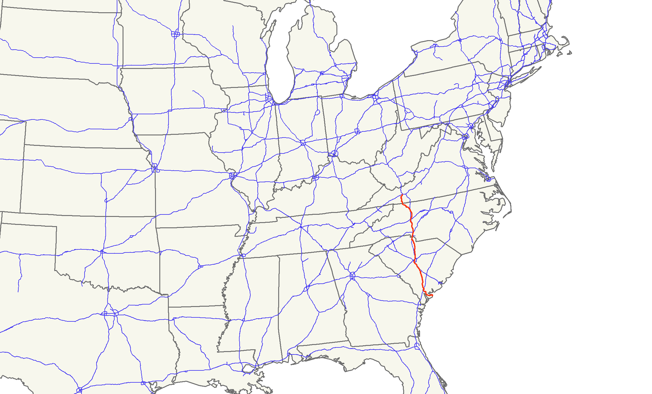
U.S. Route 21

Route information Length: 391 mi[2][3][4] (629 km) Existed: 1926[1] – present Major junctions South end: Hunting Island State Park, SC  I-95 near Yemassee, SC
 I-26 (three times in SC)
 I-20 in Columbia, SC
 I-77 (numerous times in SC/NC)
 I-85 in Charlotte, NC
 I-40 in Statesville, NC
North end: 
 I-81 / US 52 in Wytheville, VA
Highway system United States Numbered Highways
List • Bannered • Divided • Replaced
← I-20SC SC 22  →
→←  NC 20
NC 20NC NC 22  →
→←  SR 20
SR 20VA SR 22  →
→U.S. Route 21 is a north–south United States highway of 391 miles (629 km), from Hunting Island State Park, South Carolina to Wytheville, Virginia.
Contents
Route description
South Carolina
US 21 begins at Hunting Island State Park, at the intersection of a walking trail (formally a road); the road continues south to Fripp Island. US 21 travels east to Beaufort, where it widens to four lanes, continuing to Yemassee, where it converts back to a rural two-lane road. The route bypasses Orangeburg to the north, continuing afterward as a straight, rural two-lane road. Near Gaston, US 21 conjoins US 321, becoming an urban highway through Cayce, West Columbia, and Columbia (passing near the state capital building). In north Columbia, US 21 splits from US 321, reverting to a rural two-lane road parallel to I-77. In York County, US 21 enters urban areas again, connecting Rock Hill and Fort Mill. Near the North Carolina state line, US 21 merges with I-77 near Carowinds, then enters North Carolina. US 21 travels 231.5 miles (372.6 km) through the state, mostly as a two-lane, rural road; most sections can be skipped by Interstate highway.
North Carolina
US 21 begins as a concurrency with I-77, which it repeats three times within the state. Its first break with I-77 is along Statesville Avenue, then proceeding through Huntersville and Cornelius, however, because of its close proximity to I-77 and NC 115, it has no interchange with Interstate 485. The second break with I-77 occurs at Mooresville, where US 21 travels through the city and then northwest into Statesville. After Statesville, 21 travels northeast to Harmony and Brooks Crossroads, before merging back with I-77 near Jonesville. North of Elkin, 21 splits with I-77 for the last time and goes north to Sparta, passing the Blue Ridge Parkway after a major, curvy section. North of Sparta, at Twin Oaks, US 221 overlaps with US 21 before entering Virginia. US 21 travels 124.5 miles (200.4 km) through the western Piedmont of North Carolina, either combined with I-77 or as a two-lane rural road; from the South Carolina state line to Elkin, travelers can easily skip a majority of US 21 via I-77.
Virginia
After a few miles crossing the state line, US 21 reaches the town of Independence, where it splits with US 221 and continues north. The route goes through the Mount Rogers National Recreation Area before entering the city of Wytheville. After a short concurrency with US 11 in downtown Wytheville, it goes north and ends at the intersection of I-81/US 52. US 21 travels 35 miles (56 km) through western Virginia, mostly as a 2-lane rural mountain road.
Junction list
- Mileposts reset at state line crossings.
South Carolina
County Location Mile[2] # Destinations Notes Beaufort 0 Hunting Island State Park US 21 begins at intersection of walking trail, road continues south to Fripp Island Beaufort 14.5 


 US 21 Bus. north / SC 802 east
East end of SC 802 overlap 17 SC 802 west (Ribaut Road)West end of SC 802 overlap 20.5
US 21 Bus. south (Boundary Street)24  SC 170 south – Burton
27  SC 116 west – Laurel Bay
Gardens Corner 34.5  US 17 north (Charleston Highway) – Charleston
North end of US 17 overlap Pocotaligo 41 

US 17 south / US 17 Alt. north – Ridgeland, YemasseeSouth end of US 17 and US 17 Alt overlap Hampton Yemassee 45  SC 62 west (Yemassee Highway) – Varnville, Hampton
Colleton 48.5
US 17 Alt. north (Hendersonville Highway) – WalterboroNorth end of US 17 Alt overlap 51 I-95 – Florence, Savannah61  SC 63 (Sniders Highway) – Varnville, Walterboro
67.5  SC 64 (Bells Highway) – Ehrhardt, Walterboro
Smoaks 76  SC 217 (Lodge Highway) – Lodge
Bamberg 82  SC 61 (Edisto River Road) – Bamberg
Orangeburg Branchville 88  US 78 – Bamberg, Charleston
Brief .2 miles (0.32 km) concurrency 88.5  SC 210 north – Bowman
Orangeburg 103.8
US 21 Bus. north (Rowesville Road)104 

 US 178 east (Charleston Highway) / US 178 Bus. – Summerville, Charleston
East end of US 178 overlap 105  US 301 (Five Chop Road) – Santee
106  SC 33 (Russel Street) – Cameron
107  US 601 (Magnolia Street) – St. Matthews
108
US 178 (Chestnut Street) / US 21 Bus. (Columbia Road) – NorthWest end of US 178 overlap Calhoun 120 
 SC 6 south (Cawcaw Road) / SC 172 west (Bull Swamp Road) – St. Matthews, North
South end of SC 6 overlap 122 SC 6 north (Center Hill Road) – SwanseaNorth end of SC 6 overlap Lexington 127 I-26 – Columbia, CharlestonCalhoun 130  US 176 east (Old State Road) – St. Matthews
East end of US 176 overlap Lexington 137 I-26 – Columbia, Charleston138  US 321 south – Gaston, Swansea
South end of US 321 overlap Cayce 141  To I-77 (Fish Hatchery Road) – Charlotte
141.5 I-26 – Charleston, Spartanburg142.5  SC 2 north (Frink Road)
West Columbia 144  SC 302 south (Airport Boulevard) – Aiken, Columbia Metropolitan Airport
146 SC 2 (State Street)Richland Columbia 147 
 US 1 / US 378 (Gervais Street)
To South Carolina State House 147.5  SC 12 (Hampton/Tylor Streets)
To Finlay Park and Columbia Museum of Art 148 
 I-126 west / US 76 west – Greenville, Spartanburg
West end of US 76 overlap 148.5 US 76 east (Elmwood Avenue)East end of US 76 overlap 149 US 176 west (River Drive)West end of US 176 overlap 150  SC 16 (Sunset Drive)
151  SC 215 north (Montichello Road)
To Columbia International University 152 US 321 north (Fairfield Street)North end of US 321 overlap, Columbia College at intersection 154 I-20 – Florence, Augusta161 I-77 – Columbia, Charlotte161  SC 555 (Farrow Road) – Columbia
Fairfield Ridgeway 171  SC 34 – Lugoff, Camden, Winnsboro Mills
Brief .2 miles (0.32 km) concurrency 188  SC 200 – Winnsboro
South end of SC 200 overlap Chester Great Falls 191  SC 99 north (Chester Avenue) – Richburg
192  SC 97 / SC 200 north – Chester, Lancaster
North end of SC 200 overlap, brief .1 miles (0.16 km) concurrency with SC 97 Fort Lawn 200  SC 9 (Chester Avenue) – Richburg, Lancaster
205  SC 223 (Wylies Mill Road) – Richburg
York Lesslie 212  SC 5 south – Lexington
South end of SC 5 overlap; to Andrew Jackson State Park Rock Hill 216 Springfield Road – Lesslie Exit ramps not clearly marked 217 I-77 – Columbia, Charlotte217.5
US 21 Bus. north / SC 5 north (Main Street)North end of SC 5 overlap 218  SC 121 south (Cowan Road)
South end of SC 121 overlap 219  SC 122 (Dave Lyle Boulevard)
221
US 21 Bus. south (Cherry Road) / SC 121North end of SC 121 overlap 222  I-77 / SC 161 west (Celanese Road) – Columbia, Charlotte
Fort Mill 223.5
US 21 Bus. north (Spratt Street)225  SC 160
229
US 21 Bus. south (Old Nation Road)230  SC 51 north (Pineville-Rock Hill Road) – Pineville
230.5 I-77 south / Carowinds Boulevard – ColumbiaSouth end of I-77 overlap; to Carowinds US 21 overlaps with Interstate 77 (exits 90 to North Carolina state line) North Carolina
County Location Mile[3] # Destinations Notes Mecklenburg Charlotte US 21 overlaps with Interstate 77 (South Carolina state line to exit 16) 16 I-77 north – StatesvilleNorth end of I-77 overlap 16.5  NC 155 north (Old Statesville Road)
19  NC 24 (W.T. Harris Boulevard)
Huntersville 25.5  NC 73 (Sam Fur Road) – Concord
Cornelius 25.5 I-77 south – CharlotteSouth end of I-77 overlap US 21 overlaps with Interstate 77 (exits 28 to 33) Iredell Mooresville 33.5 I-77 north – StatesvilleNorth end of I-77 overlap 36.5  NC 150 (Plaza Drive)
36.5 NC 155 south (Statesville Highway)South end of NC 155 overlap 43 I-77 – Charlotte, StatesvilleStatesville 51  US 70 (Garner Bagnal Boulevard) – Conover, Salisbury
52 

 US 64 west (Front Street) / NC 90 west (Water Street) / NC 115 north (Center Street)
US 21 zig-zags through downtown Statesville; west end of US 64 overlap, north end of NC 115 overlap 53 US 64 east (Davie Avenue) – MocksvilleEast end of US 64 overlap 54 I-40 – Hickory, Winston-Salem57.5 I-77 – Statesville, ElkinHarmony 67  NC 901 (Memorial Highway) – Union Grove
Yadkin Brooks Crossroads 79  US 421 – Wilkesboro, Yadkinville, Winston-Salem
85.5
I-77 south / US 21 Bus. north – Statesville, JonesvilleSouth end of I-77 overlap US 21 overlaps with Interstate 77 (exits 79 to 83) Surry Elkin 90 I-77 north – WythevilleNorth end of I-77 overlap; southbound exit and northbound entrance 91.5 
 NC 268 – Elkin
To Elkin Municipal Airport 93
US 21 Bus. south / Popular Springs Road – ElkinNorthbound turn left on Popular Springs Road to US 21 Business Alleghany 111 Blue Ridge Parkway Sparta 118.5  NC 18 (Whitehead Street) – Laurel Springs
Twin Oaks 121  US 221 south – Jefferson
South end of US 221 overlap Virginia
County Location Mile[4] # Destinations Notes Grayson Independence 4  US 58 / US 221 north (Main Street) – Mouth of Wilson, Galax
North end of US 221 overlap Elk Creek 13 Corners Rock Road Wythe Speedwell 21 
 SR 619 east / SR 749 west
Wytheville 33.5  US 11 (Lee Highway/Main Street)
Brief .4 miles (0.64 km) concurrency 35 I-81 / US 52 – Bristol, RoanokeUS 21 ends 1.000 mi = 1.609 km; 1.000 km = 0.621 mi
Concurrency terminus • Closed/Former • Incomplete access • UnopenedHistory
US 21 in the pre-Interstate era was a north–south highway connecting the area around Lake Erie and the coastal South. One of the few true north–south routes to cross the middle Appalachian Mountains, it became an important corridor for motor traffic between northeastern Ohio, western Pennsylvania, (with U.S. Route 19) and western New York state and central North Carolina, central and southeastern South Carolina, and by connecting with other highways, coastal Georgia and most of Florida.
US 21 originally (in 1926) connected Cleveland, Ohio and Yemassee, South Carolina. In 1935 it was extended to Beaufort, South Carolina, and again in 1953 to its current southern terminus at the Atlantic Coast at Hunting Island State Park, between the city of Beaufort and Fripp Island.[5]
In the Interstate Highway era much of U.S. 21 became an obvious corridor for a long-distance expressway. The West Virginia Turnpike between Charleston, West Virginia, and Princeton, West Virginia, was the first segment of a planned series of toll highways along or near US 21 from Cleveland, Ohio to Charlotte, North Carolina. All of the other toll highways were shelved in favor of freeways built with Interstate funding; these freeways and the West Virginia Turnpike became Interstate 77, which completely supplants old U.S. 21 as a long-distance through route. Interstate 77 was later extended to Columbia, South Carolina, also within a few miles of US 21.
Between Cleveland and Charleston, all but a relatively short segment of US 21 was completely deleted in favor of Interstate 77, the relics being State Route 21 and State Route 821 between Byesville, Ohio and Marietta, Ohio. The section of U.S. 21 between Mineral Wells and Charleston is now signed as County Route 21 (circular shield) in all four counties along the route (Wood, Wirt, Jackson, and Kanawha).
Between Charleston and its current northern terminus at Wytheville, Virginia, almost all of US 21 coincided with either U.S. Highway 60, U.S. Route 19, or U.S. Highway 52, which remained as US 21 was deleted. The short segment of US 21 in southern West Virginia not coinciding with another U.S. route became an extension of West Virginia Route 16.
In North Carolina, US 21 originally entered the state along today's NC 51 into Pineville, then followed Old Pineville Road into Charlotte. In the mid-1930s, US 21 moved over to South Boulevard from Old Pineville Road. In 1969, US 21 was rerouted following today's I-77 alignment, the old route was replaced by an extension of US 521. From 1975-1987, US 21 moved north in segments onto I-77 to its current alignment ending at exit 16A (Sunset Road). Further north, US 21 originally followed Old Statesville Road, replaced in 1956 by NC 115. In 1966, US 21 was bypassed around Jonesville and Elkin, replaced with US 21 Business route.[6]
Bannered routes
South Carolina business loops
There are four U.S. Route 21 Business loop in South Carolina:
- Beaufort – A 4.4-mile (7.1 km) route that goes through downtown Beaufort, via Sea Island Parkway, Carteret Street and Boundary Street.[7]
- Orangeburg – A 2.7-mile (4.3 km) route that goes through downtown Orangeburg, via Magnolia Street.[8]
- Rock Hill – A 6.6-mile (10.6 km) route that goes through downtown Rock Hill, via Main Street, Oakland Street and Cherry Road.[9]
- Fort Mill – A 7.1-mile (11.4 km) route that goes through downtown Fort Mill, via Spratt Street and Old Nation Road.[10]
North Carolina business loop
There is one U.S. Route 21 Business loop in North Carolina:
- Elkin – It is a 7.8-mile (12.6 km) route that goes through downtown Jonesville and Elkin. The route was established in 1966 after mainline US 21 moved east onto a completed section of I-77.[11][12]
See also
Related U.S. routes
References
- ^ "US Highways from US 1 to US 830". http://www.us-highways.com/us1.htm#US_21. Retrieved 2011-02-02.
- ^ a b Google, Inc. Google Maps – US 21 in SC (Map). Cartography by Google, Inc. http://maps.google.com/maps?f=d&source=s_d&saddr=US-21+N%2FState+Rd+S-7-406&daddr=32.39446,-80.68124+to:32.92403,-80.85831+to:33.69169,-80.93173+to:33.85501,-81.022+to:33.91695,-81.07418+to:33.98799,-81.04643+to:34.11547,-80.98999+to:34.260892,-80.9616175+to:34.73667,-80.90525+to:34.9506,-80.99774+to:35.07296,-80.93542+to:I-77+N&hl=en&geocode=FdIX7gEduoY0-w%3BFdxM7gEd6OYw-ykb7RYx3gz8iDHGPNLiL0d0ew%3BFX5h9gEdOjMu-yl9JU6egE35iDErBacgoCGK4A%3BFSoYAgIdbhQt-ymPxxkX9874iDFmOgDlxE2boQ%3BFSKWBAId0LMr-yl5I2VMRLj4iDE87_PFx9RZ2w%3BFRaIBQId_Ocq-ylpTcIDVbn4iDHLXuBHIw96Fw%3BFZadBgIdYlQr-ykbW7gIPLv4iDFT6WiJmpR8YA%3BFY6PCAId2jAs-ynj73XeIKb4iDGG2D_eSO6WLw%3BFZzHCgIdr58s-ykfyx4lYQNWiDHg6jKVz1daxg%3BFR4KEgId3nst-ylf4OS4LnpWiDH2WzYgWfFZXQ%3BFchNFQIdlBIs-yn33j0yo4hWiDGaFIc2a4ywrg%3BFcArFwIdBAYt-ynnTKxxIptWiDF_kexPt6IOZA%3BFf6hFwIdDBct-w&mra=dpe&mrcr=0&mrsp=5&sz=12&via=1,2,3,4,5,6,7,8,9,10,11&sll=33.916013,-80.968895&sspn=0.212826,0.445976&ie=UTF8&ll=33.715202,-80.419922&spn=3.41286,7.13562&z=8. Retrieved 2011-02-01.
- ^ a b Google, Inc. Google Maps – US 21 in NC (Map). Cartography by Google, Inc. http://maps.google.com/maps?f=d&source=s_d&saddr=I-77+N&daddr=35.33978,-80.84222+to:35.450738,-80.8669896+to:35.60639,-80.83859+to:35.736758,-80.8980744+to:35.7843879,-80.8854998+to:35.827681,-80.874724+to:35.93103,-80.78013+to:36.14551,-80.78297+to:US-21+N%2FUS-221+N&hl=en&geocode=Ff6hFwIdDBct-w%3BFQQ-GwIdFHIu-ynXhM_jD6dWiDHqjwYW4gPVWg%3BFXLvHAIdUxEu-ynDMEdtEKlWiDEqvqAdEJGcgA%3BFXZPHwIdQoAu-ymHyzxpCVVRiDFp7RYGin8CXg%3BFbZMIQId5pct-ymPSpwvU1dRiDGyPDp24QndKQ%3BFcMGIgIdBckt-ynxR4kCnVlRiDFb3Evqye4Vsw%3BFeGvIgIdHPMt-ymX5mAWNVlRiDEsQC3zyFANjQ%3BFZZDJAIdnmQv-ynxgYOuwN9TiDFIMvYY--0Oeg%3BFWaJJwIdhlkv-ykXsYEqQtZTiDHif8x5kl90UQ%3BFbgDLgId3rEp-w&mra=dpe&mrcr=0&mrsp=5&sz=15&via=1,2,3,4,5,6,7,8&sll=35.785931,-80.868173&sspn=0.026005,0.055747&ie=UTF8&ll=35.773258,-79.898071&spn=3.328915,7.13562&z=8. Retrieved 2011-02-01.
- ^ a b Google, Inc. Google Maps – US 21 in VA (Map). Cartography by Google, Inc. http://maps.google.com/maps?f=d&source=s_d&saddr=US-21+N%2FUS-221+N%2FNew+River+Pkwy&daddr=N+4th+St&hl=en&geocode=FbgDLgId3rEp-w%3BFY73MwIdA4gq-w&mra=dme&mrcr=0&mrsp=1&sz=16&sll=36.95946,-81.097255&sspn=0.012808,0.027874&ie=UTF8&ll=36.830172,-80.973358&spn=0.821096,1.783905&z=10. Retrieved 2011-02-01.
- ^ "End of US highway 21". http://www.usends.com/20-29/021/021.html. Retrieved 2011-02-02.
- ^ "NCRoads.com: U.S. 21". http://www.members.cox.net/ncroads/us021.html. Retrieved 2011-02-02.
- ^ Google, Inc. Google Maps – US 21 Bus - Beaufort (Map). Cartography by Google, Inc. http://maps.google.com/maps?f=d&source=s_d&saddr=U.S.+21+Business&daddr=Boundary+St&hl=en&geocode=FdeY7gEdl18x-w%3BFXwB7wEdqIww-w&mra=me&mrcr=0&mrsp=1,0&sz=17&sll=32.440267,-80.703034&sspn=0.006764,0.013937&ie=UTF8&ll=32.428876,-80.679216&spn=0.054117,0.111494&z=14. Retrieved 2011-02-02.
- ^ Google, Inc. Google Maps – US 21 Bus - Orangeburg (Map). Cartography by Google, Inc. http://maps.google.com/maps?f=d&source=s_d&saddr=US-21+N%2FRowesville+Rd&daddr=Magnolia+St&hl=en&geocode=Ffq5_gEdslsu-w%3BFZJG_wEdoFMu-w&mra=me&mrcr=0&mrsp=1,0&sz=17&sll=33.506772,-80.847777&sspn=0.006683,0.013937&ie=UTF8&ll=33.493522,-80.849161&spn=0.053469,0.111494&z=14. Retrieved 2011-02-02.
- ^ Google, Inc. Google Maps – US 21 Bus - Rock Hill (Map). Cartography by Google, Inc. http://maps.google.com/maps?f=d&source=s_d&saddr=S+Carolina+5+E%2FE+Main+St&daddr=34.9357292,-81.0270953+to:Cherry+Rd&hl=en&geocode=FVLJFAIdDy4s-w%3BFbETFQId6Z8r-yntv0-N_IhWiDFBY75CZQWBtA%3BFXeWFQIdviUs-w&mra=dpe&mrcr=0&mrsp=1&sz=14&via=1&sll=34.942096,-81.009064&sspn=0.052557,0.111494&ie=UTF8&ll=34.941111,-81.003914&spn=0.105116,0.222988&z=13. Retrieved 2011-02-02.
- ^ Google, Inc. Google Maps – US 21 Bus - Fort Mill (Map). Cartography by Google, Inc. http://maps.google.com/maps?f=d&source=s_d&saddr=Unknown+road&daddr=35.0402778,-80.9285446+to:US-21+BUS+S%2FOld+Nation+Rd&hl=en&geocode=FfDsFQIdFX4s-w%3BFRWsFgId4CAt-ykFfzIbz4RWiDGsX7Qed84qUQ%3BFeAnFwIdXAYt-w&mra=dpe&mrcr=0&mrsp=1&sz=13&via=1&sll=35.03604,-80.887356&sspn=0.104994,0.222988&ie=UTF8&ll=35.033651,-80.940399&spn=0.104997,0.222988&z=13. Retrieved 2011-02-02.
- ^ Google, Inc. Google Maps – US 21 Bus - Elkin (Map). Cartography by Google, Inc. http://maps.google.com/maps?f=d&source=s_d&saddr=US-21+S%2FUS-21+BUS+S&daddr=36.253992,-80.8487545+to:US-21+S%2FUS-21+BUS+S%2FPoplar+Springs+Rd&hl=en&geocode=FRpSKAId6uwu-w%3BFSgxKQIdjlgu-ykDy23-g39RiDH4yzuihBn3fA%3BFUm7KQIdU04u-w&mra=dpe&mrcr=0&mrsp=1&sz=13&via=1&sll=36.247734,-80.825558&sspn=0.103414,0.222988&ie=UTF8&ll=36.262823,-80.768051&spn=0.206788,0.445976&z=12. Retrieved 2011-02-02.
- ^ "NCRoads.com: US 21 Business". http://www.members.cox.net/ncroads/us21b.html. Retrieved 2011-02-02.
 Main U.S. Routes
1 2 3 4 5 6 7 8 9 10 11 12 13 14 15 16 17 18 19 20 21 22 23 24 25 26 27 28 29 30 31 32 33 34 35 36 37 38 40 41 42 43 44 45 46 48 49 50 51 52 53 54 55 56 57 58 59 60 61 62 63 64 65 66 67 68 69 70 71 72 73 74 75 76 77 78 79 80 81 82 83 84 85 87 89 90 91 92 93 94 95 96 97 98 99 101 163 400 412 425 Lists U.S. Routes • Bannered • Divided • Bypassed Categories:- U.S. Highway System
- U.S. Highways in South Carolina
- U.S. Highways in North Carolina
- U.S. Highways in Virginia
- Transportation in Beaufort County, South Carolina
- Transportation in Hampton County, South Carolina
- Transportation in Colleton County, South Carolina
- Transportation in Bamberg County, South Carolina
- Transportation in Orangeburg County, South Carolina
- Transportation in Calhoun County, South Carolina
- Transportation in Lexington County, South Carolina
- Transportation in Richland County, South Carolina
- Transportation in Fairfield County, South Carolina
- Transportation in Chester County, South Carolina
- Transportation in York County, South Carolina
- Transportation in Mecklenburg County, North Carolina
- Transportation in Iredell County, North Carolina
- Transportation in Yadkin County, North Carolina
- Transportation in Surry County, North Carolina
- Transportation in Wilkes County, North Carolina
- Transportation in Alleghany County, North Carolina
- Fort Mill, South Carolina
- Rock Hill, South Carolina
- Columbia, South Carolina
- Transportation in Grayson County, Virginia
- Transportation in Wythe County, Virginia
- Transportation in Charlotte, North Carolina

Wikimedia Foundation. 2010.