- U.S. Route 54
Infobox U.S. Route
article_route=54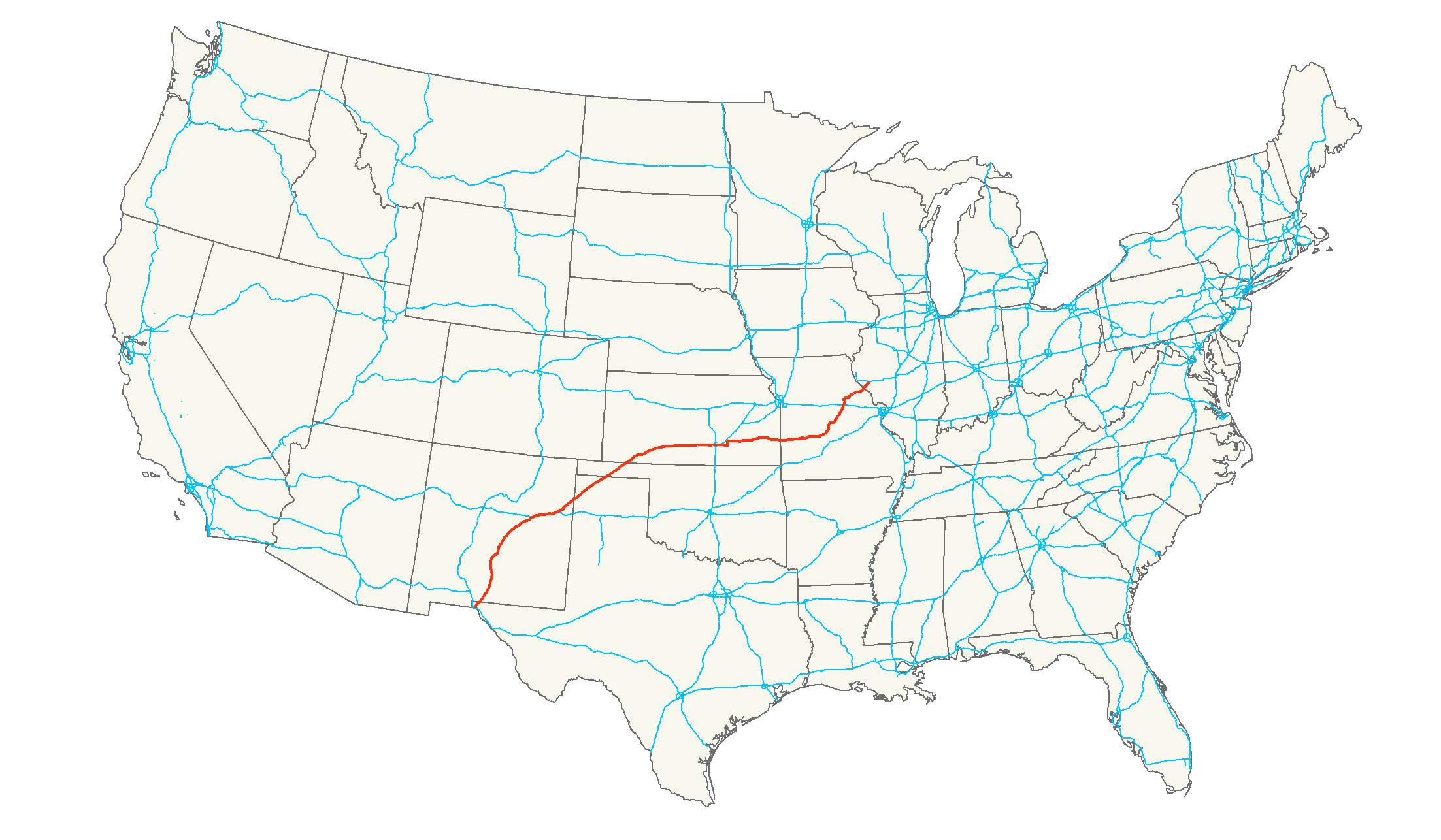
length_mi=1,197
length_ref=Droz, Robert V. [http://www.us-highways.com/usbt.htm U.S. Highways : From US 1 to (US 830)] . URL accessed23 February 2006 .]
length_km=1,926
yrcom=1926
direction_a=West
direction_b=East
from=U.S. - Mexico border at El Paso, TX
junction=Jct|state=TX|I|10 in El Paso, TX
Jct|state=NM|I|40 in Santa Rosa, NM
Jct|state=KS|I|135 in Wichita, KS
Jct|state=MO|US|63 in Jefferson City, MO
Jct|state=MO|I|70 in Kingdom City, MO
to=Jct|state=IL|I|72|IL|107 in Griggsville, ILU.S. Route 54 is an east-west
United States highway that runs northeast-southwest for 1,197 miles (1,926 km) from westernIllinois toEl Paso, Texas . It enters and leaves Texas twice.Union Pacific 's Tucumcari Line runs along US-54 from El Paso all the way toWichita, Kansas which is about 2/3 of the whole route.As of
2004 , the highway's eastern terminus isGriggsville, Illinois , atInterstate 72 andIllinois Route 107 . Its western terminus isEl Paso, Texas , at theUnited States-Mexico border .Route description
New Mexico
US 54 enters
New Mexico in Chaparral as part of theEl Paso, Texas Metro area network. It also services as a military highway to connectFort Bliss in El Paso toHolloman Air Force Base inAlamogordo, New Mexico . The highway runs north through the central portion of the state connecting toInterstate 40 inSanta Rosa, New Mexico following for 59 miles to Tucumcari. The highway then exits the state back intoTexas at Nara Visa. The highway runs for 354 miles and through the major New Mexico cities of Alamogordo, Vaughn, Santa Rosa and Tucumcari.Texas
US 54 begins in
El Paso, Texas at Loop 375 downtown. The highway serves as a majorfreeway for the Metro area's network running North/South along the city's eastern slope of the Franklin Mountains range. The highway runs through the city for approximately 23 miles before reaching theNew Mexico State Line. Within the network it is a military connector forFort Bliss andHolloman Air Force Base .The highway re-enters the
Texas Panhandle just beyond Nara Visa, New Mexico and continues northeast for 95 miles to the Oklahoma border. Major Texas cities along US 54 are El Paso, North Hills, Dalhart and Stratford.Oklahoma
US-54 runs through the
Oklahoma Panhandle from southwest to northeast. It enters at Texhoma, then continues northeast through Goodwell before entering Guymon. In Guymon, it intersects US-412 and begins a concurrency with US-64. It goes northeast through Optima and Hooker, where US-64 turns east. After going northeast through Tyrone, it enters Kansas just before entering Liberal, Kansas.Kansas
US-54 enters the state from Oklahoma in Seward County, and travels through the cities of Liberal and Plains, where it begins a concurrency with US-160 in Meade County. Just east of the city of Meade, US-54 splits from US-160 and continues in a northeasterly direction through Meade and Ford counties before beginning a long concurrency with US-400 in Mullinville in Kiowa County.
The highway then travels through the town of Greensburg and continues as a two-lane road through Pratt, Cunningham, and Kingman. The road becomes an at-grade expressway in eastern Kingman County in the outer suburbs of the Wichita area.
The expressway continues into Sedgwick County, entering the city limits of Wichita near
Wichita Mid-Continent Airport . In Wichita, US-54/400 is known as Kellogg Avenue, and has junctions with Interstate 235, Interstate 135 and Interstate 35, theKansas Turnpike , before a junction with K-96.The concurrency of US-54 and US-400 continues through Augusta in Butler County before US-400 heads east toward the
Missouri state line, while US-54 forms a brief concurrency with US-77 through El Dorado. At El Dorado, US-54 continues its easterly course through rural areas in Greenwood and Woodson counties before passing through the cities of Iola and Fort Scott, with US-77 heading north to Junction City. US-54 exits Kansas in Bourbon County before reachingNevada, Missouri .Missouri
In Missouri US 54 angles from southwest portion of the state to the northeast portion of the state. It is a major conduit through the
Ozarks and is the primary access road toPomme de Terre Lake andLake of the Ozarks . After entering the state it passes through Nevada, El Dorado Springs, Hermitage, crossing Lake of the Ozarks the first time just north ofHa Ha Tonka State Park . It passes through Camdenton and cross the lake a second time at theGrand Glaize Bridge at Osage Beach before bypassing Eldon and going through Jefferson City where it crosses theMissouri River at theJefferson City Bridge where it briefly overlaps U.S. Route 63. Just north of the bridge it splits passing through Fulton, crossing Interstate 70 atKingdom City, Missouri , passing through Mexico, passing just north of Vandalia, and ultimately crossing theMississippi River into Illinois at Louisiana.Illinois
In the state of
Illinois , U.S. 54 runs from theChamp Clark Bridge over theMississippi River to its terminus atInterstate 72 northeast near Griggsville. Before the eastern terminus was cut back to I-72, U.S. 54 continued northeast to downtownChicago . It is a rural, two-lane surface street for its entire length in Illinois. In the state of Illinois, U.S. 54 is convert|23.96|mi|km|2 long.cite web |author=Illinois Technology Transfer Center |url=http://www.dot.state.il.us/gist2/select.html |title=T2 GIS Data |accessdate=2007-11-08 |date=2006]History
Until the 1970s it reached Chicago before it was truncated in favor of
U.S. Route 36 ,Illinois Route 54 , andU.S. Route 45 .ee also
Related U.S. Routes
*
U.S. Highway 154 References
###@@@KEYEND@@@###
Wikimedia Foundation. 2010.