- Nara Visa, New Mexico
-
Nara Visa, New Mexico — Unincorporated comumunity — Along U.S. Route 54 in Nara Visa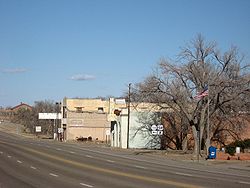
Country United States State New Mexico County Quay Population (2000) – Total 112 Time zone CST[1] (UTC-6) – Summer (DST) CDT (UTC-5) ZIP Code 88430 Area code(s) 575 Nara Visa is an unincorporated community in Quay County, New Mexico, United States. Although it is unincorporated, it has a post office, with the ZIP code of 88430.[2] The population of the ZCTA for 88430 was 112 at the 2000 census.[3]
Contents
History
Nara Visa traces its beginnings to brothers Sim and Fred McFarland of La Veta, Colorado. The brothers originally came to New Mexico to work on their uncle's cattle ranch. When word came that the Rock Island Railroad would be building a track through the area, the McFarlands moved to a location near the proposed route.[4] The community was first known as Narvaez, named after the Narvaez family.[5]
Henry F. King came to the site in November 1901 to be the first section foreman. At that time, there were no structures aside from the depot. He and his wife lived in a boxcar where they boarded trainmen, section men, and occasionally cowboys. In January 1902, the section house was constructed. Soon two small stores were built.[4]
The community's first school was constructed in 1906. By 1910, there were a total of four active churches. In 1919, Nara Visa had eight saloons, at least three dance halls, drugs stores, general merchandise stores, a barber shop, butcher shops, millinery shops, auto suppliers, hotels, garages, and a bank.[4]
See also
References
- ^ While geographically located within the Mountain Time Zone, the town observes Central Time — 2 local towns enter 2000 in unique way
- ^ Zip Code Lookup
- ^ 88430 - Fact Sheet - American FactFinder
- ^ a b c Moncus (Editor), Mary Lynn; Marian Farmer Knapp (Editor) (1985). Quay County. Quay County Book Committee. pp. 154–159.
- ^ Moncus (Editor), Mary Lynn; Marian Farmer Knapp (Editor) (1985). Quay County. Quay County Book Committee. p. 62.
External links
 Media related to Nara Visa, New Mexico at Wikimedia Commons
Municipalities and communities of Quay County, New Mexico City 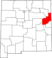
Villages Unincorporated
communitiesFootnotes ‡This populated place also extends into Texas
Coordinates: 35°36′27″N 103°05′59″W / 35.6075°N 103.09972°W
Categories:- New Mexico geography stubs
- Populated places in Quay County, New Mexico
- Unincorporated communities in New Mexico


Wikimedia Foundation. 2010.