- U.S. Route 83
Infobox U.S. Route
article_route=83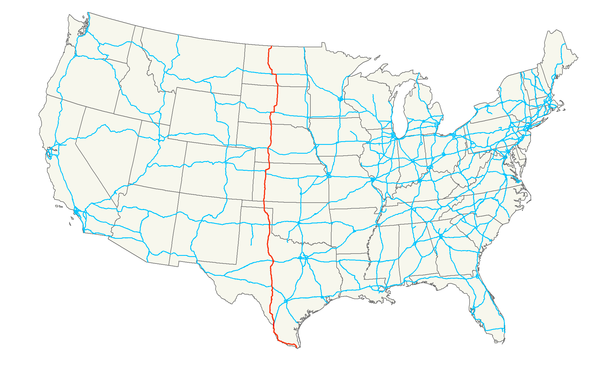
length_mi=1,894Droz, Robert V. [http://www.us-highways.com/usbt.htm U.S. Highways : From US 1 to (US 830)] . URL accessed 02:55, 4 July 2006 (UTC).]
length_km=3,048
yrcom=1926
direction_a=South
direction_b=North
from=
junction=Jct|state=TX|I|35 from Laredo to Botines, TX
Jct|state=TX|I|10 at Junction, TX
Jct|state=TX|I|20 at Abilene, TX
Jct|state=TX|I|40 at Shamrock, TX
Jct|state=KS|I|70 near Oakley, KS
Jct|state=NE|I|80 at North Platte, NE
Jct|state=SD|I|90 from Murdo to Vivian, SD
Jct|state=SD|US|14 at Pierre, SD
Jct|state=ND|I|94 from Sterling to Bismarck, ND
to=Jct|state=MB|Hwy|83|noshield1=83 at Canadian Border near Westhope, NDU.S. Route 83 is one of the longest north-south
U.S. Highway s in theUnited States , at convert|1885|mi|km. Only three other north-south routes are longer:U.S. 1 ,U.S. 41 andU.S. 87 . The highway's northern terminus is north ofWesthope, North Dakota , at the Canadian border, where it continues asManitoba Highway 83 . The southern terminus is inBrownsville, Texas , at theVeteran's International Bridge on the Mexican border, connecting withMexican Federal Highway 180 .Route description
Texas
Oklahoma
US-83 traverses the Oklahoma panhandle along the western border of Beaver County, but in this brief convert|37|mi|km|sing=on stretch it encounters no fewer than three other federal highways. Approximately ten miles from the Texas line, US-83 intersects US-412 in the hamlet of Bryan's Corner. Continuing its journey northward, the highway crosses the Beaver River, then intersects US-64 in Turpin. US-83 North and US-64 East are co-signed for three northbound miles, where US-64 turns eastward. At this intersection, US-270 West joins the highway, and together with US-83 proceeds northbound for the final six miles (10 km) to the Kansas line.
Kansas
US 83 enters the Sunflower State in Seward County, approximately four miles south of Liberal, where it intersects US 54. North of Liberal, US 83 begins a multiplex with US 160, and the highways remained joined until reaching Sublette, the seat of Haskell County. US 83 and US 160 split north of Sublette, with US 160 heading west toward Ulysses, and US 83 continuing north toward Garden City.
At Garden City, US 50 and US 400 join US 83 for a brief concurrency through the downtown area. Just north of downtown, US 83 splits and heads north toward Scott City, while US 50 and US 400 remain joined through the rest of the state. The highway passes through largely unpopulated areas of Finney County and Scott County before reaching a junction with K-96 in downtown Scott City.
In northern Scott County, K-4 has its origins at US 83, heading east toward Healy, and US 83 traverses through rolling farmlands until reaching Oakley, the seat of Logan County. US 83 reaches US 40 less than a mile west of Interstate 70, and the two highways jog west for a brief multiplex before US 83 splits and crosses I-70.
North of I-70, US 83 begins a concurrency with K-383, formerly US 383. Passing to the east of Gem in Thomas County, US 83/K-383 takes a sharp northeasterly track through Rexford and Selden. After passing through Selden, K-383 splits from US 83 and continues northeast to US 36, while US 83 meets the beginning of K-23.
US 83 returns to a northerly course at the Sheridan County-Decatur County line, and passes through Oberlin at US 36. Oberlin is the last area of significant population the highway passes in Kansas; the next city is
McCook, Nebraska .Nebraska
U.S. 83 enters Nebraska south of McCook, where it meets
U.S. Route 6 andU.S. Route 34 . It continues northward to North Platte, where it intersectsInterstate 80 andU.S. Route 30 . After leaving North Platte in a northeasterly direction, it turns north near Stapleton and goes north through the Sand Hills to Valentine. For convert|5|mi|km before Valentine, it runs concurrent withU.S. Route 20 . After passing through Valentine, it continues north to enter South Dakota.outh Dakota
U.S. 83 enters South Dakota south of Olsonville on a segment of highway which passes through the
Rosebud Indian Reservation . After a brief overlap withU.S. Route 18 in Mission, the route turns north and meetsInterstate 90 at Murdo. The two routes overlap as U.S. 83 goes east with I-90 until Vivian, where U.S. 83 turns north. At Fort Pierre, U.S. 83 meetsU.S. Route 14 andSouth Dakota Highway 34 . The three highways overlap as they cross theMissouri River and enter Pierre. At Pierre, SD 34 separates and U.S. 83 turns northeast with U.S. 14. They separate near Blunt and U.S. 83 turns northward. U.S. 83 briefly overlaps withU.S. Route 212 near Gettysburg and withU.S. Route 12 through the Selby area. U.S. 83 leaves South Dakota north of Herreld.The South Dakota section of U.S. 83, with the exception of concurrencies with
U.S. 18 ,Interstate 90 ,U.S. 14 ,U.S. 212 , andU.S. 12 , is defined at South Dakota Codified Laws § 31-4-180. [http://legis.state.sd.us/statutes/DisplayStatute.aspx?Type=Statute&Statute=31-4-180]North Dakota
U.S. 83 enters
North Dakota at the South Dakota line, and runs northward toInterstate 94 . It follows I-94 west to Bismarck, at which point it resumes a generally northward course and is a four-lane highway. It traverses mostly agricultural land, with such towns as Washburn and Underwood, although some largestrip-mining coal (lignite ) operations can be seen from the roadway in the vicinity of Falkirk.North of Coleharbor, the roadway and an adjacent railroad line cross a viaduct separating
Lake Sakakawea fromLake Audubon . Other than the lakes, the surroundings are mostly cropland and grazing land.Route 83 passes directly through Minot, where it is known as Broadway, although a bypass to the west of town is an alternative route. From Minot, the northbound route passes
Minot Air Force Base where it becomes a two-lane highway again, shares a roadway with eastboundNorth Dakota Highway 5 , and diverges from N.D. 5 to head north to the Canadian border.Major intersections
*
U.S. Highway 2 /U.S. Highway 52 in Minot, North Dakota
*Interstate 94 concurrent between Bismarck and Sterling,North Dakota
*U.S. Highway 12 Near Selby, South Dakota
*U.S. Highway 14 west of Blunt, South Dakota
*Interstate 90 concurrent between Vivian and Murdo,South Dakota
*U.S. Highway 18 west of Misson, South Dakota
*U.S. Highway 20 in Valentine, Nebraska
*U.S. Highway 30 in North Platte, Nebraska
*Interstate 80 inNorth Platte, Nebraska
*U.S. Highway 6 andU.S. Highway 34 in McCook, Nebraska
*U.S. Highway 36 in Oberlin, Kansas
*U.S. Highway 24 east of Colby, Kansas
*Interstate 70 inOakley, Kansas
*U.S. Highway 40 in Oakley, Kansas
*U.S. Highway 50 andU.S. Highway 400 in Garden City, Kansas
*U.S. Highway 56 in Sublette, Kansas
*U.S. Highway 54 in Liberal, Kansas
* U.S. Highway 64 and U.S. Highway 270 south of Liberal, Kansas (in Oklahoma)
*U.S. Highway 60 north ofCanadian, Texas
*Interstate 40 inShamrock, Texas
*U.S. Highway 70 andU.S. Highway 62 inPaducah, Texas
*U.S. Highway 82 inGuthrie, Texas
*Interstate 20 andU.S. Highway 84 inAbilene, Texas
*U.S. Highway 67 inBallinger, Texas
*Interstate 10 inJunction, Texas
*U.S. Highway 90 inUvalde, Texas
*U.S. Highway 57 south of Uvalde
*Interstate 35 andU.S. Highway 59 inLaredo, Texas
*U.S. Highway 281 inPharr, Texas
*U.S. Highway 77 inHarlingen, Texas ee also
Related U.S. Routes
*
U.S. Highway 183
*U.S. Highway 283
*U.S. Highway 383 References
###@@@KEYEND@@@###
Wikimedia Foundation. 2010.