- Oberlin, Kansas
-
Oberlin, Kansas — City — Downtown Oberlin, Kansas in 2001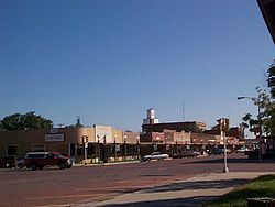 Location of Oberlin, Kansas
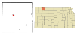 Detailed map of Oberlin
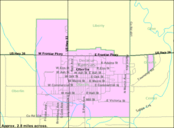
Coordinates: 39°49′16″N 100°31′42″W / 39.82111°N 100.52833°W Country United States State Kansas County Decatur Founded 1872 Platted 1878 Incorporated 1885 [1] Government – Mayor Joe Stanley – Administrator Karen Larson Area – Total 1.9 sq mi (5.0 km2) – Land 1.9 sq mi (5.0 km2) – Water 0.0 sq mi (0.0 km2) Elevation 2,562 ft (781 m) Population (2010)[2] – Total 1,788 – Density 941.1/sq mi (363.3/km2) Time zone Central (CST) (UTC-6) – Summer (DST) CDT (UTC-5) ZIP code 67749 Area code(s) 785 FIPS code 20-52000[3] GNIS feature ID 0471014[4] Website OberlinKS.com Oberlin is a city in and the county seat of Decatur County, Kansas, United States.[5] As of the 2010 census, the city population was 1,788.[2]
Contents
History
On September 30, 1878, Northern Cheyenne fleeing from Indian Territory to their homes in the north, the Northern Cheyenne Exodus, attacked homesteaders near Oberlin, then a tiny hamlet. The Last Indian Raid in Kansas room in the Decatur County Museum and a monument in the town cemetery near the graves of the victims commemorate those depredations.[6][7] Oberlin was platted as a town in 1878.[8]
Geography
Oberlin is located at 39°49′16″N 100°31′42″W / 39.82111°N 100.52833°WCoordinates: 39°49′16″N 100°31′42″W / 39.82111°N 100.52833°W (39.821235, -100.528369) at an elevation of 2,562 feet (781 m).[4][9] It lies on the northwest side of Sappa Creek, a tributary of the Republican River, in the High Plains region of the Great Plains.[10] Located at the intersection of U.S. Route 36 and U.S. Route 83 in northwest Kansas, Oberlin is 228 miles (367 km) northwest of Wichita, 238 miles (383 km) east of Denver, and 320 miles (510 km) west-northwest of Kansas City.[10][11]
According to the United States Census Bureau, the city has a total area of 1.9 square miles (4.9 km2), all of it land.[12]
Climate
Lying in the transition zone between North America's humid subtropical climate (Köppen Cfa), humid continental climate (Köppen Dfa), and semi-arid climate (Köppen BSk), Oberlin experiences hot, humid summers and cold, dry winters. The average temperature in Oberlin is 52 °F (11 °C) with temperatures exceeding 90 °F (32 °C) an average of 62 days a year and dropping below 32 °F (0 °C) an average of 158 days a year. Oberlin typically experiences precipitation 66 days a year and snowfall 11 days a year. Precipitation averages 23 inches (574 mm) per year, and snowfall averages 32 inches (80 cm) per year.[13] On average, January is the coldest month, and July is both the hottest month and the wettest month. The hottest temperature recorded in Oberlin was 111 °F (44 °C) in 1954; the coldest temperature recorded was -31 °F (-35 °C) in 1989.[14]
Climate data for Oberlin, Kansas, USA Month Jan Feb Mar Apr May Jun Jul Aug Sep Oct Nov Dec Year Record high °F (°C) 78
(26)85
(29)93
(34)97
(36)103
(39)110
(43)111
(44)109
(43)107
(42)99
(37)88
(31)83
(28)111
(44)Average high °F (°C) 40
(4)46
(8)55
(13)65
(18)74
(23)86
(30)92
(33)89
(32)81
(27)69
(21)51
(11)43
(6)66
(18.8)Daily mean °F (°C) 28
(−2)33
(1)41
(5)51
(11)61
(16)72
(22)77
(25)75
(24)66
(19)54
(12)38
(3)30
(−1)52.2
(11.2)Average low °F (°C) 13
(−11)17
(−8)25
(−4)35
(2)47
(8)57
(14)63
(17)60
(16)50
(10)36
(2)24
(−4)16
(−9)36.9
(2.7)Record low °F (°C) −28
(−33)−19
(−28)−25
(−32)10
(−12)22
(−6)34
(1)41
(5)40
(4)22
(−6)9
(−13)−19
(−28)−31
(−35)−31
(−35)Precipitation inches (mm) 0.49
(12.4)0.63
(16)1.65
(41.9)2.20
(55.9)3.65
(92.7)3.30
(83.8)3.75
(95.3)2.74
(69.6)1.50
(38.1)1.17
(29.7)1.03
(26.2)0.48
(12.2)22.59
(573.8)Snowfall inches (cm) 6.5
(16.5)4.8
(12.2)6.7
(17)2.4
(6.1)0
(0)0
(0)0
(0)0
(0)0.3
(0.8)1.1
(2.8)4.5
(11.4)5.2
(13.2)31.6
(80.3)Avg. precipitation days (≥ 0.01 in) 2.7 3.1 5.5 6.1 9.3 7.7 8.0 7.3 5.3 4.5 3.8 2.8 66.2 Avg. snowy days (≥ 0.1 in) 2.5 1.8 2.3 0.8 0 0 0 0 0.1 0.2 1.4 2.1 11.2 Source: National Weather Service;[13] The Weather Channel[14] Demographics
Historical populations Census Pop. %± 1890 976 — 1900 937 −4.0% 1910 1,157 23.5% 1920 1,247 7.8% 1930 1,629 30.6% 1940 1,878 15.3% 1950 2,019 7.5% 1960 2,337 15.8% 1970 2,291 −2.0% 1980 2,387 4.2% 1990 2,197 −8.0% 2000 1,994 −9.2% 2010 1,788 −10.3% U.S. Decennial Census As of the census[3] of 2000, there were 1,994 people, 879 households, and 550 families residing in the city. The population density was 1,039.7 people per square mile (401.0/km²). There were 1,048 housing units at an average density of 546.5 per square mile (210.7/km²). The racial makeup of the city was 97.79% White, 0.25% African American, 0.15% Native American, 0.20% Asian, 0.05% Pacific Islander, 0.25% from other races, and 1.30% from two or more races. Hispanic or Latino of any race were 1.15% of the population.
There were 879 households out of which 25.8% had children under the age of 18 living with them, 51.8% were married couples living together, 7.6% had a female householder with no husband present, and 37.4% were non-families. 36.2% of all households were made up of individuals and 20.7% had someone living alone who was 65 years of age or older. The average household size was 2.15 and the average family size was 2.78.
In the city the population was spread out with 22.6% under the age of 18, 5.1% from 18 to 24, 21.0% from 25 to 44, 21.4% from 45 to 64, and 29.9% who were 65 years of age or older. The median age was 46 years. For every 100 females there were 85.1 males. For every 100 females age 18 and over, there were 79.3 males.
The median income for a household in the city was $30,816, and the median income for a family was $34,583. Males had a median income of $27,177 versus $16,488 for females. The per capita income for the city was $17,271. About 5.0% of families and 6.8% of the population were below the poverty line, including 7.1% of those under age 18 and 4.4% of those age 65 or over.
Arts and culture
Oberlin is home to the Last Indian Raid Museum, which contains multiple late 19th and early 20th century buildings filled with artifacts chronicling the history of Oberlin and early Plains settlers. Examples include a 1930s grocery store and a one-room school house built in 1922.[15]
Oberlin is also home to a recreation center completed in 2010 that is home to a 3D-capable, one-screen movie theater and a bowling alley.[16]
Parks and recreation
The Oberlin City Park is near the Decatur Community High School and has a playground, picnic shelter, band shell, full basketball court, and is home to the Oberlin swimming pool.
Sappa Park
The City of Oberlin is the owner of the Sappa Park two miles east of town. Formerly a state park complete with a lake, Sappa Park today is home to a man-made wetlands, bike and hiking paths, a nine hole disc golf course, and a shelter house built by the Works Progress Administration in the 1930s. The park is currently in the middle of a multi-year improvement project. Adjacent to the park is a 9-hole golf course.[17]
The park was developed in 1935 by the National Park Service, with the Works Progress Administration (WPA) hiring unemployed young men to build the park's dam and shelter house. The park was dedicated in 1939, but over the years silt filled up the lake and it was drained. Only recently has part of the lake been restored as a wetlands. [18]
Government
Oberlin is a city of the third class, according to state statute, with a mayor-council form of government.[19] The city council consists of five members and meets on the first and third Thursday of each month at 7PM.[20][21]
Education
Oberlin USD 294 operates two public schools in the city: Oberlin Elementary School (Grades Pre-K-6) and Decatur Community Junior/Senior High School (7-12).[22][23]
Media
Print
Oberlin has one weekly newspaper, The Oberlin Herald.[24]
Radio
The following radio stations are licensed to and/or broadcast from Oberlin:
FM
Frequency Callsign[25] Format[26] City of License Notes 91.3 KRLE Christian Contemporary Oberlin, Kansas K-LOVE[26] 101.1 KFNF Country Oberlin, Kansas - Television
Oberlin is in the Wichita-Hutchinson, Kansas television market.[27] NBC affiliate KSNK, licensed to McCook, Nebraska, broadcasts on channel 8 from studios west of Oberlin.[28] KSNK is a satellite station of KSNW in Wichita.[29]
Notable people
Notable individuals who were born in and/or have lived in Oberlin include:
- Brun Campbell, ragtime composer, pianist[30]
- Elmer Hackney, National Football League running back[31]
- Richard Dean Rogers, U.S. federal judge[32]
References
- ^ Oberlin - History
- ^ a b "2010 City Population and Housing Occupancy Status". U.S. Census Bureau. http://factfinder2.census.gov/faces/tableservices/jsf/pages/productview.xhtml?pid=DEC_10_PL_GCTPL2.ST13&prodType=table. Retrieved March 27, 2011.
- ^ a b "American FactFinder". United States Census Bureau. http://factfinder.census.gov. Retrieved 2008-01-31.
- ^ a b "US Board on Geographic Names". United States Geological Survey. 2007-10-25. http://geonames.usgs.gov. Retrieved 2008-01-31.
- ^ "Find a County". National Association of Counties. http://www.naco.org/Counties/Pages/FindACounty.aspx. Retrieved 2011-06-07.
- ^ "Last Indian Raid Museum"
- ^ Pages 177 to 191, Holding Stone Hands: On the Trail of the Cheyenne Exodus, by Alan Boye, Bison Books (September 1, 2001), trade paperback: 347 pages, ISBN 0803261853 ISBN 978-0803261853
- ^ Columbia-Lippincott Gazeteer, 1952 Edition, p. 1361
- ^ "US Gazetteer files: 2010, 2000, and 1990". United States Census Bureau. 2011-02-12. http://www.census.gov/geo/www/gazetteer/gazette.html. Retrieved 2011-04-23.
- ^ a b "2003-2004 Official Transportation Map". Kansas Department of Transportation. 2003. http://www.ksdot.org/burtransplan/maps/HistoricStateMaps/2003-04Mapside.pdf. Retrieved 2011-05-24.
- ^ "City Distance Tool". Geobytes. http://www.geobytes.com/citydistancetool.htm. Retrieved 2011-05-24.
- ^ "Kansas: 2000 - Population and Housing Counts". United States Census Bureau. July 2003. p. 12. http://www.census.gov/prod/cen2000/phc-3-18.pdf. Retrieved 2011-05-24.
- ^ a b "NOWData - NOAA Online Weather Data". National Weather Service Forecast Office - Goodland, KS. http://www.weather.gov/climate/xmacis.php?wfo=gld. Retrieved 2011-05-27.
- ^ a b "Average weather for Oberlin, KS". The Weather Channel. http://www.weather.com/outlook/health/fitness/wxclimatology/monthly/graph/USKS0430. Retrieved 2011-05-27.
- ^ "Virtual Tour". Last Indian Raid Museum. Last Indian Raid Museum. http://www.rootsweb.ancestry.com/~ksdclirm/museum_tour.htm. Retrieved 2011-07-29.
- ^ "Recreational Activities". Oberlin, Kansas Official Web Site. Oberlin-Decatur Economic Development Board. http://oberlinks.com/index.php?option=com_content&task=view&id=69&Itemid=59. Retrieved 2011-07-29.
- ^ "Sappa Park". Oberlin Explorations. The Kansas Sampler Foundation. http://www.getruralkansas.org/Oberlin/116Explore/767.shtml. Retrieved 2011-07-29.
- ^ Davis, Kimberley (27 July 2011). "National agency developed park east of Oberlin". The Oberlin Herald (Oberlin, Kansas).
- ^ "Oberlin". Directory of Kansas Public Officials. The League of Kansas Municipalities. http://www.lkm.org/directory/cities.php?ID=213. Retrieved 2011-05-27.
- ^ Oberlin - Government
- ^ Oberlin - City Council Agenda
- ^ "USD 294". Oberlin USD 294. http://www.usd294.org/vnews/display.v/SEC/USD%20294. Retrieved 2011-05-27.
- ^ "Oberlin, Kansas". City-Data. http://www.city-data.com/city/Oberlin-Kansas.html. Retrieved 2011-05-27.
- ^ "Oberlin Herald". Mondo Times. http://www.mondotimes.com/1/world/us/16/934/2409. Retrieved 2011-05-27.
- ^ Frequency and callsign information from "FMQ FM Radio Database Query". Federal Communications Commission. http://www.fcc.gov/mb/audio/fmq.html. Retrieved 2009-09-07.
- ^ a b "Radio Stations in Oberlin, Kansas". Radio-Locator. http://www.radio-locator.com/cgi-bin/locate?select=city&city=Oberln%2C+KS&x=0&y=0&sid=. Retrieved 2011-05-27.
- ^ "TV Market Maps". EchoStar Knowledge Base. http://dishuser.org/TVMarkets/. Retrieved 2011-05-27.
- ^ "Station Search". BIA Kelsey. http://www.bia.com/Research-and-Forecasts/Broadcast-Media-Resources/Station-Search/resources_search_result.asp?calls=KSNK&media=TV. Retrieved 2011-05-27.
- ^ "Stations for Goodland, Kansas". RabbitEars.Info. http://www.rabbitears.info/market.php?request=print_market&mktid=87. Retrieved 2011-05-27.
- ^ "Brun Campbell". AllMusic. http://www.allmusic.com/artist/brun-campbell-p25464. Retrieved 2011-05-27.
- ^ "Elmer Hackney". National Football League. http://www.nfl.com/players/elmerhackney/profile?id=HAC711924. Retrieved 2011-05-27.
- ^ "Rogers, Richard Dean". Biographical Directory of Federal Judges. Federal Judicial Center. http://www.fjc.gov/servlet/nGetInfo?jid=2042&cid=999&ctype=na&instate=na. Retrieved 2011-05-27.
Further reading
- History of the State of Kansas; William G. Cutler; A.T. Andreas Publisher; 1883. (Online HTML eBook)
- Kansas : A Cyclopedia of State History, Embracing Events, Institutions, Industries, Counties, Cities, Towns, Prominent Persons, Etc; 3 Volumes; Frank W. Blackmar; Standard Publishing Co; 944 / 955 / 824 pages; 1912. (Volume1 - Download 54MB PDF eBook),(Volume2 - Download 53MB PDF eBook), (Volume3 - Download 33MB PDF eBook)
External links
- City
- Schools
- USD 294, local school district
- Maps
- Oberlin City Map, KDOT
- Decatur County Map, KDOT
Municipalities and communities of Decatur County, Kansas Cities 
Townships Unincorporated
communitiesAllison | Cedar Bluffs | Kanona | Leoville | Lyle | Traer
Footnotes ‡This populated place also has portions in an adjacent county or counties
Categories:- Cities in Kansas
- County seats in Kansas
- Populated places in Decatur County, Kansas
- Populated places established in 1878


Wikimedia Foundation. 2010.