- Norcatur, Kansas
-
Norcatur, Kansas — City — Location of Norcatur, Kansas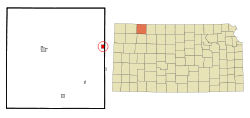
Coordinates: 39°50′11″N 100°11′18″W / 39.83639°N 100.18833°WCoordinates: 39°50′11″N 100°11′18″W / 39.83639°N 100.18833°W Country United States State Kansas County Decatur Area – Total 1.0 sq mi (2.6 km2) – Land 1.0 sq mi (2.6 km2) – Water 0.0 sq mi (0.0 km2) Elevation 2,644 ft (806 m) Population (2010)[1] – Total 151 – Density 151/sq mi (58.3/km2) Time zone Central (CST) (UTC-6) – Summer (DST) CDT (UTC-5) ZIP code 67653 Area code(s) 785 FIPS code 20-50925[2] GNIS feature ID 0471026[3] Norcatur is a city in Decatur County, Kansas, United States. As of the 2010 census, the city population was 151.[1]
Contents
History
Norcatur's name is the result of its location on the Norton and Decatur county lines.
Geography
Norcatur is located at 39°50′11″N 100°11′18″W / 39.83639°N 100.18833°W (39.836514, -100.188402)[4]. According to the United States Census Bureau, the city has a total area of 1.0 square mile (2.6 km2), all of it land.
Demographics
Historical populations Census Pop. %± 1990 198 — 2000 169 −14.6% 2010 151 −10.7% U.S. Decennial Census As of the census[2] of 2000, there were 169 people, 81 households, and 54 families residing in the city. The population density was 169.0 people per square mile (65.3/km²). There were 104 housing units at an average density of 104.0 per square mile (40.2/km²). The racial makeup of the city was 100.00% White.
There were 81 households out of which 17.3% had children under the age of 18 living with them, 60.5% were married couples living together, 4.9% had a female householder with no husband present, and 32.1% were non-families. 30.9% of all households were made up of individuals and 19.8% had someone living alone who was 65 years of age or older. The average household size was 2.09 and the average family size was 2.58.
In the city the population was spread out with 16.6% under the age of 18, 2.4% from 18 to 24, 26.0% from 25 to 44, 22.5% from 45 to 64, and 32.5% who were 65 years of age or older. The median age was 51 years. For every 100 females there were 79.8 males. For every 100 females age 18 and over, there were 93.2 males.
The median income for a household in the city was $24,750, and the median income for a family was $29,792. Males had a median income of $23,125 versus $16,250 for females. The per capita income for the city was $14,028. About 7.3% of families and 12.4% of the population were below the poverty line, including 9.5% of those under the age of eighteen and 23.8% of those sixty five or over.
References
- ^ a b "2010 City Population and Housing Occupancy Status". U.S. Census Bureau. http://factfinder2.census.gov/faces/tableservices/jsf/pages/productview.xhtml?pid=DEC_10_PL_GCTPL2.ST13&prodType=table. Retrieved September 14, 2011.
- ^ a b "American FactFinder". United States Census Bureau. http://factfinder.census.gov. Retrieved 2008-01-31.
- ^ "US Board on Geographic Names". United States Geological Survey. 2007-10-25. http://geonames.usgs.gov. Retrieved 2008-01-31.
- ^ "US Gazetteer files: 2010, 2000, and 1990". United States Census Bureau. 2011-02-12. http://www.census.gov/geo/www/gazetteer/gazette.html. Retrieved 2011-04-23.
External links
- City
- Schools
- USD 294, local school district
- Maps
- Norcatur City Map, KDOT
- Decatur County Map, KDOT
Municipalities and communities of Decatur County, Kansas Cities 
Townships Unincorporated
communitiesAllison | Cedar Bluffs | Kanona | Leoville | Lyle | Traer
Footnotes ‡This populated place also has portions in an adjacent county or counties
Categories:- Cities in Kansas
- Populated places in Decatur County, Kansas


Wikimedia Foundation. 2010.