- Sappa Township, Decatur County, Kansas
-
Sappa Township — Township — Location in Decatur County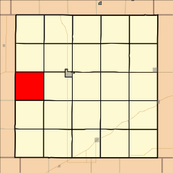
Coordinates: 39°47′00″N 100°41′07″W / 39.7833333°N 100.68528°WCoordinates: 39°47′00″N 100°41′07″W / 39.7833333°N 100.68528°W Country United States State Kansas County Decatur Area – Total 36 sq mi (93.25 km2) – Land 35.99 sq mi (93.21 km2) – Water 0.01 sq mi (0.04 km2) 0.04% Elevation 2,743 ft (836 m) Population (2000) – Total 43 – Density 1.2/sq mi (0.5/km2) GNIS feature ID 0471007 Sappa Township is a township in Decatur County, Kansas, USA. As of the 2000 census, its population was 43.
Geography
Sappa Township covers an area of 36 square miles (93 km2) and contains no incorporated settlements.
References
External links
Municipalities and communities of Decatur County, Kansas Cities 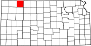
Townships Unincorporated
communitiesAllison | Cedar Bluffs | Kanona | Leoville | Lyle | Traer
Footnotes ‡This populated place also has portions in an adjacent county or counties
Categories:- Townships in Decatur County, Kansas
- Kansas geography stubs


Wikimedia Foundation. 2010.