- U.S. Route 121
-
For the former route, see U.S. Route 121 (1926).

U.S. Route 121 is a proposed highway designated as the Coalfields Expressway, a four lane highway stretching from Beckley, West Virginia to Pound, Virginia, approximately 62 miles (100 km) in length. It is designed to connect Interstate 77/Interstate 64 in West Virginia near Beckley to U.S. Route 23 in Wise County, Virginia at Pound.
While U.S. 121 will not connect directly to U.S. Route 21, it will intersect at the latter road's original alignment, now a part of I-77.
Contents
History
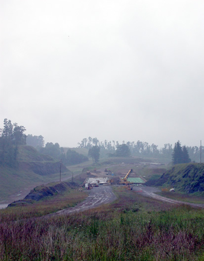
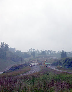 The Coalfields Expressway interchange with WV 54 under construction in 2004 near Sophia, West Virginia.
The Coalfields Expressway will depart from an expanded Interstate 64/Interstate 77 interchange and travel southwest through depressed areas of West Virginia to U.S. Route 23 in Wise County, Virginia at Pound. The roadways US 121 will replace are deficient in the fact that the existing roadways have limited passing opportunities, steep grades, and low design speeds. The expressway will generally follow West Virginia Route 16 through Raleigh and Wyoming Counties, West Virginia Route 83 in McDowell County, and State Route 83 in Buchanan County, Virginia to U.S. 23 in Pound.
West Virginia
Construction started in 1999 with a three-level diamond interchange near Welch in western West Virginia. This will facilate traffic going between the King Coal Highway/Interstate 73/Interstate 74 and the Coalfields Expressway (US 121). Grading work was completed in 2003, but the interchange remains incomplete as of 2010.
Further eastward, work is continuing on a segment of the Expressway in the vicinity of Sophia and Crab Orchard near Beckley totaling 3.5 miles (5.6 km). Grading and preliminary paving operations have been completed, as well as the gradings and bridge construction for a diamond interchange for West Virginia Route 54 and a bridge over West Virginia Route 16. In November 2004, a contract was awarded for paving operations at a cost of $11.5 million from Surveyor Creek Road to the West Virginia Route 16 interchange. With this segment of the Expressway completed, a new tie-in will be complete from Surveyor Creek Road to five-lane West Virginia Route 16, as well as an interchange with West Virginia Route 54.
Two contracts totaling $22.2 million are currently under construction. One projects involves grading and drainage operations on 2.57 miles (4.14 km) of US 121 from Big Ridge to Surveyor Creek Road that involves nearly five million cubic yards of excavation.
Virginia
In Virginia, the Coalfields Expressway will run for 55 miles (89 km), following Virginia Route 83 from the West Virginia border to U.S. Highway 23 in Pound. Near the Grundy - Vansant area, U.S. Route 460 will become a new four lane highway connecting the Coalfields Expressway with Breaks Interstate Park at the Virginia / Kentucky border and Elkhorn City, Kentucky.
Proposed Interstate 66 connection
Interstate 66 is a proposed cross-state highway from the far reaches of western Kentucky to Pike County. The limited-access highway in Pike County would begin at U.S. Route 23 south of Pikeville and proceed northeast and north of Fishtrap Lake to Kimper. It would continue to McVeigh along Kentucky Route 199, and cross the Tug Fork River south of Matewan, West Virginia and connect with the King Coal Highway (U.S. Route 52) in Mingo County, West Virginia.
The proposed Interstate 66 would then run south of U.S. Route 119 (Corridor G) but north of US 121 (Coalfields Expressway) and include a new four-lane highway and a two-lane tunnel. All three roadways, Interstate 66, US 121 (Coalfields Expressway), and US 119 (Corridor G) are independent of each other.
As of 2004, the proposal for Interstate 66 in West Virginia is effectively dead. If any Interstate 66 routing is made in West Virginia, it would most likely follow an upgraded Coalfields Expressway to Beckley.
References
- Interstate 66. Kentucky Transportation Cabinet. 20 June 2003 [1].
- Coalfields Expressway Web Site. Coalfields Expressway Authority. 20 June 2003 [2].
- Lokay, Roger W. E-mail to the author.
External links
- Official Virginia DOT Coalfields Expressway Web Site
- Official West Virginia DOT Coalfields Expressway Web Site
See also
- List of U.S. Routes
Browse numbered routes ←  US 119
list WV 122  →Categories:
- Three-digit U.S. Highways
- U.S. Highways in West Virginia
- Transportation in Wise County, Virginia
- Transportation in Dickenson County, Virginia
- Transportation in Buchanan County, Virginia
- Transportation in Raleigh County, West Virginia
- Transportation in Wyoming County, West Virginia
- Transportation in McDowell County, West Virginia
- U.S. Highways in Virginia
- Proposed U.S. Highways

Wikimedia Foundation. 2010.