- Mingo County, West Virginia
-
Mingo County, West Virginia 
Location in the state of West Virginia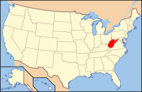
West Virginia's location in the U.S.Founded 1895 Seat Williamson Area
- Total
- Land
- Water
424 sq mi (1,098 km²)
423 sq mi (1,096 km²)
1 sq mi (3 km²), 0.24%Population
- (2000)
- Density
28,253
67/sq mi (26/km²)Mingo County is a county located in the U.S. state of West Virginia. As of the 2010 census, the population was 26,839.[1] Its county seat is Williamson[1]. Created in 1895, Mingo is West Virginia's newest county. It is named for the historic Iroquoian Mingo people.
Contents
Geography
According to the U.S. Census Bureau, the county has a total area of 424 square miles (1,097 km²), of which 423 square miles (1,095 km²) is land and 1 square mile (3 km²) (0.24%) is water.
Major highways
 U.S. Highway 52
 U.S. Highway 119
 West Virginia Route 49
 West Virginia Route 65
 West Virginia Route 80
Adjacent counties
- Lincoln County (north)
- Logan County (northeast)
- Wyoming County (east)
- McDowell County (southeast)
- Pike County, Kentucky (west)
- Martin County, Kentucky (west)
- Wayne County (northwest)
- Buchanan County, Virginia (southeast)
Demographics
Historical populations Census Pop. %± 1900 11,359 — 1910 19,431 71.1% 1920 26,384 35.8% 1930 38,319 45.2% 1940 40,802 6.5% 1950 47,409 16.2% 1960 39,742 −16.2% 1970 32,780 −17.5% 1980 37,336 13.9% 1990 33,739 −9.6% 2000 28,253 −16.3% As of the census[2] of 2000, there were 28,253 people, 11,303 households, and 8,217 families residing in the county. The population density was 67 people per square mile (26/km²). There were 12,898 housing units at an average density of 30 per square mile (12/km²). The racial makeup of the county was 96.39% White, 2.34% Black or African American, 0.24% Native American, 0.21% Asian, 0.02% Pacific Islander, 0.06% from other races, and 0.74% from two or more races. 0.48% of the population were Hispanic or Latino of any race.
There were 11,303 households out of which 33.50% had children under the age of 18 living with them, 56.20% were married couples living together, 12.70% had a female householder with no husband present, and 27.30% were non-families. 25.20% of all households were made up of individuals and 10.40% had someone living alone who was 65 years of age or older. The average household size was 2.49 and the average family size was 2.98.
In the county, the population was spread out with 24.20% under the age of 18, 9.20% from 18 to 24, 29.10% from 25 to 44, 25.00% from 45 to 64, and 12.40% who were 65 years of age or older. The median age was 37 years. For every 100 females there were 93.70 males. For every 100 females age 18 and over, there were 90.20 males.
The median income for a household in the county was $21,347, and the median income for a family was $26,581. Males had a median income of $31,660 versus $18,038 for females. The per capita income for the county was $12,445. About 25.90% of families and 29.70% of the population were below the poverty line, including 38.90% of those under age 18 and 18.60% of those age 65 or over.
History
Mingo County is the newest county in the state, formed by an act of the state legislature in 1895 from parts of Logan County. Its founding was related to a legal protest by a moonshiner, who claimed that the Logan County Court that had found him guilty did not have jurisdiction over his case, because his still was actually located in Lincoln County. A land survey was taken and discovered that the defendant was correct. The charges were then refiled in Lincoln County court. Although the moonshiner was ultimately found guilty of his crime, the state legislature was made aware of the situation and determined that Logan County was too large for the expeditious administration of justice and decided to create a new county, called Mingo. The county was named in honor of the Mingo Native American tribe, which had been the earliest known settlers of the region.
The attempt to unionize coal miners in the county in the 1920s led to the Battle of Blair Mountain in neighboring Logan County.
Notable residents
- Don Blankenship, president and CEO of Massey Energy
- H. Truman Chafin, state senator
- Robert H. "Doc" Foglesong
- James H. "Buck" Harless, a timber and coal operator via International Industries
Cities and towns
Incorporated cities and towns
Unincorporated communities
- Baisden
- Borderland
- Breeden
- Chattaroy
- Dingess
- Edgarton
- Gilbert Creek
- Isaban (part)
See also
- Elk Creek Wildlife Management Area
- Laurel Lake Wildlife Management Area
- National Register of Historic Places listings in Mingo County, West Virginia
References
- ^ "Find a County". National Association of Counties. http://www.naco.org/Counties/Pages/FindACounty.aspx. Retrieved 2011-06-07.
- ^ "American FactFinder". United States Census Bureau. http://factfinder.census.gov. Retrieved 2008-01-31.
External links
- Mingo County official website
- Mingo County Board of Education
- Mingo County History
- East Fork VFD at Dingess, WV

Wayne County Lincoln County Logan County Martin County, Kentucky and Pike County, Kentucky 
Wyoming County  Mingo County, West Virginia

McDowell County and Buchanan County, Virginia Municipalities and communities of Mingo County, West Virginia City 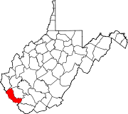
Towns CDPs Chattaroy | Gilbert Creek | Justice | Red Jacket
Other
communitiesFootnotes ‡This populated place also has portions in an adjacent county or counties
Categories:- West Virginia counties
- Mingo County, West Virginia
- 1895 establishments
- Secession in the United States


Wikimedia Foundation. 2010.