- Myrtle, West Virginia
-
Myrtle, West Virginia — Unincorporated community — 
 Myrtle, West Virginia
Coordinates: 37°46′04″N 82°11′28″W / 37.76778°N 82.19111°WCoordinates: 37°46′04″N 82°11′28″W / 37.76778°N 82.19111°W Country United States State West Virginia County Mingo Elevation 722 ft (220 m) Time zone Eastern (EST) (UTC-5) – Summer (DST) EDT (UTC-4) Area code(s) 304 & 681 GNIS feature ID 1555186[1] Myrtle is an unincorporated community in Mingo County, West Virginia, United States. Myrtle is located on U.S. Route 119 and the Trace Fork 8 miles (13 km) northeast of Williamson.[2] Myrtle had a post office, which opened on September 2, 1891, and closed on August 22, 1992.[3]
References
- ^ "Myrtle". Geographic Names Information System, U.S. Geological Survey. http://geonames.usgs.gov/pls/gnispublic/f?p=gnispq:3:::NO::P3_FID:1555186.
- ^ West Virginia Department of Transportation (2011). Mingo County, West Virginia General Highway Map (Map). p. 1. http://gis.wvdot.com/gti/County_Maps/Mingo_1_of_2.pdf. Retrieved November 10, 2011.
- ^ "Postmaster Finder - Post Offices by ZIP Code". United States Postal Service. http://webpmt.usps.gov/pmt008.cfm. Retrieved November 10, 2011.
Municipalities and communities of Mingo County, West Virginia City 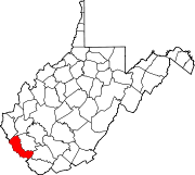
Towns CDPs Chattaroy | Gilbert Creek | Justice | Red Jacket
Other
communitiesFootnotes ‡This populated place also has portions in an adjacent county or counties
Categories:- Populated places in Mingo County, West Virginia
- Unincorporated communities in West Virginia
- Metro Valley geography stubs


Wikimedia Foundation. 2010.