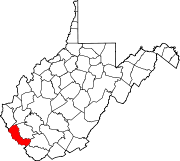
- Nolan, West Virginia
-
Nolan, West Virginia — Unincorporated community — Coordinates: 37°44′23″N 82°19′53″W / 37.73972°N 82.33139°WCoordinates: 37°44′23″N 82°19′53″W / 37.73972°N 82.33139°W Country United States State West Virginia County Mingo Elevation 650 ft (198 m) Time zone Eastern (EST) (UTC-5) - Summer (DST) EDT (UTC-4) Area code(s) 304 & 681 GNIS feature ID 1544188[1] Nolan is an unincorporated community in Mingo County, West Virginia, United States. Nolan is located on the Tug Fork along U.S. Route 52 and U.S. Route 119, 5.5 miles (8.9 km) northwest of Williamson.
References
Municipalities and communities of Mingo County, West Virginia County seat: Williamson City Towns CDPs Chattaroy | Gilbert Creek | Justice | Red Jacket
Other
communitiesFootnotes ‡This populated place also has portions in an adjacent county or counties
Categories:- Populated places in Mingo County, West Virginia
- Unincorporated communities in West Virginia
- Metro Valley geography stubs
Wikimedia Foundation. 2010.


