- Delorme, West Virginia
-
Delorme, West Virginia — Unincorporated community — 
 Delorme, West Virginia
Coordinates: 37°34′09″N 82°08′31″W / 37.56917°N 82.14194°WCoordinates: 37°34′09″N 82°08′31″W / 37.56917°N 82.14194°W Country United States State West Virginia County Mingo Elevation 725 ft (221 m) Time zone Eastern (EST) (UTC-5) - Summer (DST) EDT (UTC-4) Area code(s) 304 & 681 GNIS feature ID 1538118[1] Delorme, also known as Edgarton, is an unincorporated community in Mingo County, West Virginia, United States. Delorme is located along the Tug Fork across from the state of Kentucky.
It was formerly served by the Norfolk and Western Railway[2] and reportedly once had as many as seven bars.[2]
References
- ^ "US Board on Geographic Names". United States Geological Survey. 2007-10-25. http://geonames.usgs.gov. Retrieved 2008-01-31.
- ^ a b Goodell, Jeff (November 29, 2010). "The Dark Lord of Coal Country". Rolling Stone. http://www.rollingstone.com/politics/news/the-dark-lord-of-coal-country-20101129?page=3. Retrieved June 2, 2011.
Municipalities and communities of Mingo County, West Virginia County seat: Williamson City 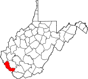
Towns CDPs Chattaroy | Gilbert Creek | Justice | Red Jacket
Other
communitiesFootnotes ‡This populated place also has portions in an adjacent county or counties
Categories:- Populated places in Mingo County, West Virginia
- Unincorporated communities in West Virginia
- Metro Valley geography stubs


Wikimedia Foundation. 2010.