- Marion County, West Virginia
-
For counties with a similar name, see Marion County (disambiguation).
Marion County, West Virginia 
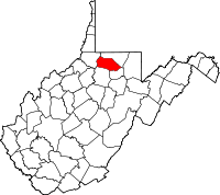
Location in the state of West Virginia
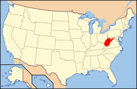
West Virginia's location in the U.S.Founded 1842 Seat Fairmont Area
- Total
- Land
- Water
311 sq mi (805 km²)
310 sq mi (803 km²)
2 sq mi (5 km²), 0.58%PopulationEst.
- (2005)
- Density
56,509
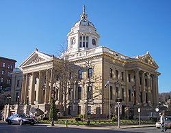
184/sq mi (71/km²)Website www.marioncountywv.com  Marion County Courthouse in Fairmont
Marion County is a county located in the U.S. state of West Virginia. As of the 2010 census, the population was 56,418. [1] Its county seat is Fairmont. Marion County was created in 1842 from parts of Monongalia and Harrison Counties, and named in honor of General Francis Marion, of American Revolutionary War fame, known in history as "The Swamp Fox."
Contents
Geography
According to the U.S. Census Bureau, the county has a total area of 311 square miles (807 km²), of which 310 square miles (802 km²) is land and 2 square miles (5 km²) (0.58%) is water.
Major highways
 Interstate 79
 U.S. Highway 19
 U.S. Highway 250
Adjacent counties
- Monongalia County (north)
- Taylor County (southeast)
- Harrison County (south)
- Wetzel County (west)
History
Marion County was formed on January 14, 1842 from portions of Harrison County and Monongalia County. It was named after Francis Marion, a.k.a. "Swamp Fox", a General in the Continental Army and later Brigade general of the South Carolina militia in the American Revolutionary War.
Demographics
Historical populations Census Pop. %± 1850 10,552 — 1860 12,722 20.6% 1870 12,107 −4.8% 1880 17,198 42.1% 1890 20,721 20.5% 1900 32,430 56.5% 1910 42,794 32.0% 1920 54,571 27.5% 1930 66,655 22.1% 1940 68,683 3.0% 1950 71,521 4.1% 1960 63,717 −10.9% 1970 61,356 −3.7% 1980 65,789 7.2% 1990 57,249 −13.0% 2000 56,598 −1.1% As of the census[1] of 2000, there were 56,598 people, 23,652 households, and 15,515 families residing in the county. The population density was 183 people per square mile (71/km²). There were 26,660 housing units at an average density of 86 per square mile (33/km²). The racial makeup of the county was 95.10% White, 3.22% Black or African American, 0.20% Native American, 0.41% Asian, 0.01% Pacific Islander, 0.13% from other races, and 0.93% from two or more races. 0.70% of the population were Hispanic or Latino of any race.
There were 23,652 households out of which 26.00% had children under the age of 18 living with them, 51.40% were married couples living together, 10.70% had a female householder with no husband present, and 34.40% were non-families. 28.90% of all households were made up of individuals and 13.90% had someone living alone who was 65 years of age or older. The average household size was 2.34 and the average family size was 2.88.
In the county, the population was spread out with 20.60% under the age of 18, 10.50% from 18 to 24, 26.40% from 25 to 44, 24.70% from 45 to 64, and 17.80% who were 65 years of age or older. The median age was 40 years. For every 100 females there were 90.60 males. For every 100 females age 18 and over, there were 87.30 males.
The median income for a household in the county was $28,626, and the median income for a family was $37,182. Males had a median income of $29,005 versus $21,100 for females. The per capita income for the county was $16,246. About 11.70% of families and 16.30% of the population were below the poverty line, including 21.30% of those under age 18 and 8.70% of those age 65 or over.
Communities
Cities
Towns
Other places
Notable natives
- David Carpenter, 376th pick in the 2006 MLB Draft by the St.Louis Cardinals.
- Frank Kendall Everest, Jr., The Fastest Man Alive
- Michael Garrison, former president of West Virginia University.
- Frank Gatski, athlete in the Pro Football Hall of Fame
- Sam Huff, Pro Football Hall of Fame
- Johnnie Johnson, musician
- John Knowles, author
- Joe Manchin, the former governor of West Virginia and current junior United States Senator from West Virginia.
- Luella Mundel, professor and McCarthyism victim
- Francis H. Pierpont, father of West Virginia
- Mary Lou Retton, all-around gymnastics Olympic gold medal winner (1984 Olympic Games).
- Rich Rodriguez, former University of Michigan head football coach.
- Nick Saban, current University of Alabama head football coach.
- Ted A. Shuttlesworth, Sr., A controversial international Evangelist
- Harrison C. Summers, WWII hero
- Jeffrey Tinnell, Producer, Publisher
- Robert Tinnell, Director, Writer, Producer
- Hershel W. Williams, Medal of Honor recipient for the Battle of Iwo Jima
- Tom Wilson, creator of the comic strip Ziggy.
- Fielding H. Yost, Football Coach
See also
- Prickett's Fort State Park
- Fairmont Marion County Transit Authority
- National Register of Historic Places listings in Marion County, West Virginia
References
- ^ "American FactFinder". United States Census Bureau. http://factfinder.census.gov. Retrieved 2008-01-31.
External links
- Marion County Government
- Times West Virginian newspaper
- Marion County Chamber of Commerce
- Marion County Convention & Visitor's Bureau
- Marion County Schools
- Marion County Parks and Recreation Commission
- Marion County Public Libraries
- Fairmont Connections.com

Monongalia County 
Wetzel County 
 Marion County, West Virginia

Harrison County Taylor County Municipalities and communities of Marion County, West Virginia Cities Towns Barrackville | Fairview | Farmington | Grant Town | Monongah | Rivesville | White Hall | Worthington
CDPs Carolina | Idamay | Rachel
Unincorporated
communitiesBaxter | Beverly Hills | Big Run | Brink‡ | Colfax | Four States | Grays Flat | Hebron | Hopewell | Kingmont | Logansport | Metz | Montana | Pine Grove | Stringtown
Footnotes ‡This populated place also has portions in an adjacent county or counties
Categories:- West Virginia counties
- Marion County, West Virginia
- 1842 establishments in the United States
- Populated places established in 1842
Wikimedia Foundation. 2010.

