- Monroe County, West Virginia
-
Monroe County, West Virginia 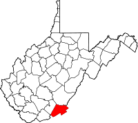
Location in the state of West Virginia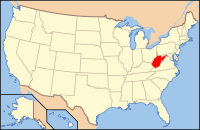
West Virginia's location in the U.S.Founded 1799 Seat Union Area
- Total
- Land
- Water
474 sq mi (1,228 km²)
474 sq mi (1,228 km²)
0 sq mi (0 km²), 0.06%Population
- (2000)
- Density
14,583
31/sq mi (12/km²)Monroe County is a county located in the U.S. state of West Virginia. As of the 2010 census, the population was 13,502. [1] Its county seat is Union[1]. Monroe County was created from Greenbrier County in 1799. It was named for James Monroe who eventually became the fifth President of the United States.
Monroe County was the home of Andrew Summers Rowan of Spanish-American War fame, who is immortalized in Elbert Hubbard's classic A Message to Garcia. The county was also the site of the 1928 discovery of the 34.48 carat (6.896 g) Jones Diamond by Grover C. Jones and his son, William "Punch" Jones.
Contents
Geography
According to the U.S. Census Bureau, the county has a total area of 474 square miles (1,227 km²), of which 473 square miles (1,226 km²) is land and 0 square miles (1 km²) (0.06%) is water.
Major highways
 U.S. Highway 219
 West Virginia Route 3
 West Virginia Route 12
 West Virginia Route 122
 West Virginia Route 311
Adjacent counties
- Greenbrier County (north)
- Alleghany County, Virginia (northeast)
- Craig County, Virginia (east)
- Giles County, Virginia (south)
- Summers County (west)
Watersheds
Tributaries of the James River, part of the Chesapeake Bay
- Potts Creek
Tributaries of the New River
Tributaries of the Greenbrier River
- Second Creek
- Sinks Grove
National Natural Landmark
- Greenville Saltpeter Cave
National protected areas
- George Washington National Forest
- Jefferson National Forest
History
Monroe County was formed on January 14, 1799 from portions of Greenbrier County. It was named after James Monroe, a Virginia statesman and senator, and the future fifth President of the United States.
Demographics
Historical populations Census Pop. %± 1800 4,188 — 1810 5,444 30.0% 1820 6,620 21.6% 1830 7,798 17.8% 1840 8,422 8.0% 1850 10,204 21.2% 1860 10,757 5.4% 1870 11,124 3.4% 1880 11,501 3.4% 1890 12,429 8.1% 1900 13,130 5.6% 1910 13,055 −0.6% 1920 13,141 0.7% 1930 11,949 −9.1% 1940 13,577 13.6% 1950 13,123 −3.3% 1960 11,584 −11.7% 1970 11,272 −2.7% 1980 12,873 14.2% 1990 12,406 −3.6% 2000 14,583 17.5% As of the census[2] of 2000, there were 14,583 people, 5,447 households, and 3,883 families residing in the county. The population density was 31 people per square mile (12/km²). There were 7,267 housing units at an average density of 15 per square mile (6/km²). The racial makeup of the county was 92.67% White, 5.98% Black or African American, 0.23% Native American, 0.16% Asian, 0.01% Pacific Islander, 0.03% from other races, and 0.92% from two or more races. 0.49% of the population were Hispanic or Latino of any race.
There were 5,447 households out of which 29.00% had children under the age of 18 living with them, 59.80% were married couples living together, 7.90% had a female householder with no husband present, and 28.70% were non-families. 25.80% of all households were made up of individuals and 13.10% had someone living alone who was 65 years of age or older. The average household size was 2.41 and the average family size was 2.88.
In the county, the population was spread out with 20.10% under the age of 18, 8.10% from 18 to 24, 30.30% from 25 to 44, 26.10% from 45 to 64, and 15.40% who were 65 years of age or older. The median age was 40 years. For every 100 females there were 79.70 males. For every 100 females age 18 and over, there were 73.80 males.
The median income for a household in the county was $27,575, and the median income for a family was $35,299. Males had a median income of $25,643 versus $22,104 for females. The per capita income for the county was $17,435. About 12.60% of families and 16.20% of the population were below the poverty line, including 21.30% of those under age 18 and 12.30% of those age 65 or over.
Government and infrastructure
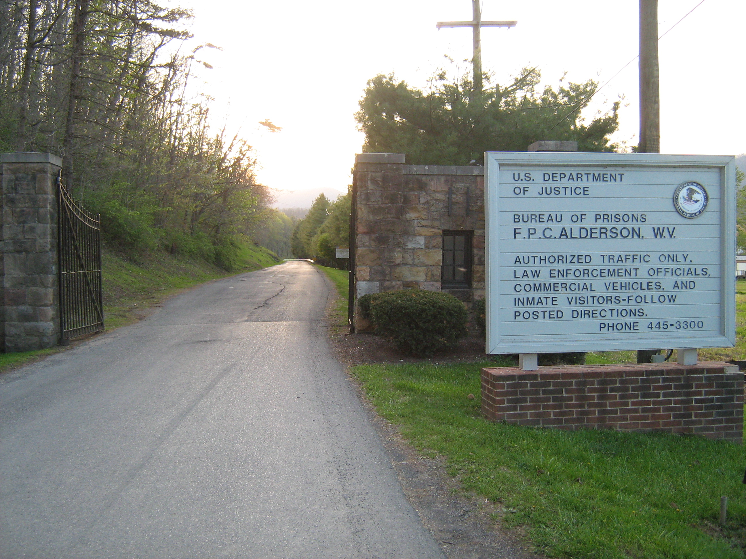
FPC Alderson
 Main article: Federal Prison Camp, Alderson
The Federal Bureau of Prisons' Federal Prison Camp, Alderson was the first women's federal prison in the country.[3] It is located in Monroe and Summers counties just west of Alderson.[4][5]
Natural Landmarks
One of Monroe County's geological features is Haynes Cave, a former saltpeter mine.[6] Strange bones were discovered by the miners at the end of the 18th Century, and mailed to Thomas Jefferson. Jefferson's study of the animal, the Megalonyx jeffersonii was arguably the birth of American paleontology. It is now the official West Virginia state fossil.
Historic Landmarks
- Indian Creek Covered Bridge
- Rehoboth Church
- Laurel Creek Covered Bridge
Cities and towns
Incorporated towns & cities
- Alderson (partially)
- Peterstown
- Union
Unincorporated communities
- Ballard
- Ballengee
- Bozoo
- Cashmere
- Cloverdale
- Crimson Springs
- Elmhurst
- Gap Mills
- Gates
- Glace
- Greenville
- Hillsdale
- Hollywood
- Keenan
- Knobs
- Laurel Branch
- Lillydale
- Lindside
- Monitor
- Pickaway
- Raines Corner
- Red Sulphur Springs
- Rock Camp
- Salt Sulphur Springs
- Sarton
- Secondcreek
- Sinks Grove
- Sweet Springs
- Waiteville
- Wayside
- Wikel
- Wolfcreek
- Zenith
Education
- James Monroe High School
- Mountain View Middle School
- Peterstown Middle School
- Peterstown Elementary School
See also
- Moncove Lake State Park
- National Register of Historic Places listings in Monroe County, West Virginia
- Bluestone Lake Wildlife Management Area
External links
References
- ^ "Find a County". National Association of Counties. http://www.naco.org/Counties/Pages/FindACounty.aspx. Retrieved 2011-06-07.
- ^ "American FactFinder". United States Census Bureau. http://factfinder.census.gov. Retrieved 2008-01-31.
- ^ Keller, Julia. "It's a gosh-darned good thing: Stewart heads to West Virginia." Chicago Tribune. October 1, 2004. Tempo 1. Retrieved on January 5, 2010.
- ^ "Martha's Prison Thanksgiving." The Cincinnati Post. November 24, 2004. Retrieved on January 5, 2010. "Mullins said the prison dormitories are in Summers County."
- ^ "FPC Alderson Contact Information." Federal Bureau of Prisons. Retrieved on January 5, 2010.
- ^ Steelhammer, Rick (2008), "W.Va.'s 'Official' Sloth Fossil on Display near Cheat Lake", Charleston Gazette, Thursday, Sept 19, 2008.

Greenbrier County Alleghany County, Virginia Summers County 
Craig County, Virginia  Monroe County, West Virginia

Giles County, Virginia Municipalities and communities of Monroe County, West Virginia Towns Alderson‡ | Peterstown | Union

Unincorporated
communitiesAssurance | Ballard | Ballengee‡ | Bozoo | Cashmere | Centennial | Cloverdale | Creamery | Crimson Springs | Dorr | Elmhurst | Gap Mills | Gates | Glace | Greenville | Hillsdale | Hollywood | Johnson Crossroads | Keenan | Knobs | Laurel Branch | Lillydale | Lindside | McGlone | Monitor | Nickells Mill | Patton‡ | Pedro | Pickaway | Raines Corner | Red Sulphur Springs | Rock Camp | Roxalia | Salt Sulphur Springs | Sarton | Secondcreek | Sinks Grove | Sweet Springs | Waiteville | Wayside | Wikel | Willow Bend | Wolfcreek | Zenith
Ghost town Indian Creek
Footnotes ‡This populated place also has portions in an adjacent county or counties
Categories:- West Virginia counties
- Monroe County, West Virginia
- 1799 establishments in the United States
- Populated places established in 1799


Wikimedia Foundation. 2010.