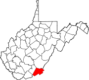
- Dorr, West Virginia
-
Dorr, West Virginia — Unincorporated settlement — Coordinates: 37°37′10″N 80°28′26″W / 37.61944°N 80.47389°WCoordinates: 37°37′10″N 80°28′26″W / 37.61944°N 80.47389°W Country United States State West Virginia County Monroe Elevation 2,228 ft (679 m) Time zone Eastern (EST) (UTC-5) - Summer (DST) EDT (UTC-4) Area code(s) 304 & 681 GNIS feature ID 1554321[1] Dorr is an unincorporated community in Monroe County, West Virginia, United States. Dorr is northeast of Union.
References
- ^ "US Board on Geographic Names". United States Geological Survey. 2007-10-25. http://geonames.usgs.gov. Retrieved 2008-01-31.
Municipalities and communities of Monroe County, West Virginia Towns Alderson‡ | Peterstown | Union
Unincorporated
communitiesAssurance | Ballard | Ballengee‡ | Bozoo | Cashmere | Centennial | Cloverdale | Creamery | Crimson Springs | Dorr | Elmhurst | Gap Mills | Gates | Glace | Greenville | Hillsdale | Hollywood | Johnson Crossroads | Keenan | Knobs | Laurel Branch | Lillydale | Lindside | McGlone | Monitor | Nickells Mill | Patton‡ | Pedro | Pickaway | Raines Corner | Red Sulphur Springs | Rock Camp | Roxalia | Salt Sulphur Springs | Sarton | Secondcreek | Sinks Grove | Sweet Springs | Waiteville | Wayside | Wikel | Willow Bend | Wolfcreek | Zenith
Ghost town Indian Creek
Footnotes ‡This populated place also has portions in an adjacent county or counties
Categories:- Populated places in Monroe County, West Virginia
- Unincorporated communities in West Virginia
- New River Greenbrier geography stubs
Wikimedia Foundation. 2010.


