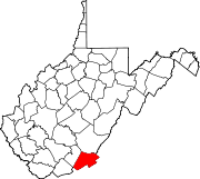
- Monitor, Monroe County, West Virginia
-
Monitor, West Virginia — Unincorporated community — Coordinates: 37°39′21″N 80°29′25″W / 37.65583°N 80.49028°WCoordinates: 37°39′21″N 80°29′25″W / 37.65583°N 80.49028°W Country United States State West Virginia County Monroe Elevation 2,234 ft (681 m) Time zone Eastern (EST) (UTC-5) – Summer (DST) EDT (UTC-4) Area code(s) 304 & 681 GNIS feature ID 1555148[1] Monitor is an unincorporated community in Monroe County, West Virginia, United States. Monitor is located on U.S. Route 219 northeast of Union.
References
Municipalities and communities of Monroe County, West Virginia Towns Alderson‡ | Peterstown | Union
Unincorporated
communitiesAssurance | Ballard | Ballengee‡ | Bozoo | Cashmere | Centennial | Cloverdale | Creamery | Crimson Springs | Dorr | Elmhurst | Gap Mills | Gates | Glace | Greenville | Hillsdale | Hollywood | Johnson Crossroads | Keenan | Knobs | Laurel Branch | Lillydale | Lindside | McGlone | Monitor | Nickells Mill | Patton‡ | Pedro | Pickaway | Raines Corner | Red Sulphur Springs | Rock Camp | Roxalia | Salt Sulphur Springs | Sarton | Secondcreek | Sinks Grove | Sweet Springs | Waiteville | Wayside | Wikel | Willow Bend | Wolfcreek | Zenith
Ghost town Indian Creek
Footnotes ‡This populated place also has portions in an adjacent county or counties
Categories:- Populated places in Monroe County, West Virginia
- Unincorporated communities in West Virginia
- New River Greenbrier geography stubs
Wikimedia Foundation. 2010.


