- U.S. Route 56
Infobox U.S. Route
article_route=56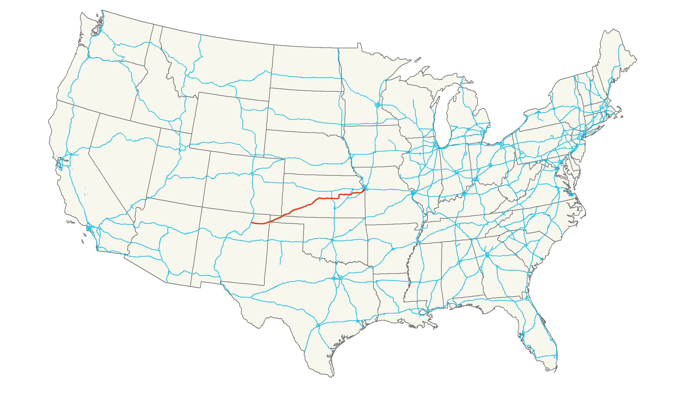
length_mi=640
length_ref=Droz, Robert V. [http://www.us-highways.com/usbt.htm U.S. Highways : From US 1 to (US 830)] . URL accessed 22:46, 20 February 2006 (UTC).]
length_km=1,030
yrcom=1957
direction_a=West
direction_b=East
from=Jct|state=NM|BL|25|dab1=Springer|US|412|NM|21 at Springer, NM
junction=Jct|state=KS|US|50 at Dodge City, KS
Jct|state=KS|I|135 at McPherson, KS
Jct|state=KS|I|35 at Gardner, KS
Jct|state=KS|US|69 at Overland Park, KS
to=Jct|state=MO|US|71 at Kansas City, MOU.S. Route 56 is an east-west
United States highway that runs for 640 miles in theMidwestern United States . The highway's eastern terminus is at U.S. Route 71 inKansas City, Missouri . Its western terminus is atBusiness Loop 25 inSpringer, New Mexico .Route description
The highway passes through
New Mexico ,Oklahoma ,Kansas , andMissouri .New Mexico
US 56 runs concurrent with
US 412 for its entire length in New Mexico; in fact, the two routes are often signed within the same shield in New Mexico. The two routes begin in Springer and head east towards Abbot, where they serve as the northern terminus of State Road 39. Continuing east, US 56/412 meet the southern terminus of NM 193 south of Farley, the northern terminus of NM 120 east of Gladstone, and the southern terminus of NM 453. US 56/412 intersectUS 64 andUS 87 inClayton, New Mexico , and US 64 joins with US 56/412 in their trek northeast. The three routes serve as the southern terminus of NM 406 as they enter theKiowa National Grassland . The three routes then cross into Oklahoma together.Oklahoma
US-56's short path through Oklahoma consists of a diagonal slice across the western part of the
Oklahoma Panhandle . US-56/64/412 enter Oklahoma near the southwest corner of the Panhandle, where they also enterRita Blanca National Grassland . They leave the grassland near Felt. Three milescite map|publisher=Oklahoma Department of Transportation|title=Official State Map|edition=Centennial|year=2007|url=http://www.odot.org/hqdiv/p-r-div/maps/state-maps/pdfs/2007.pdf|accessdate= ] (4.8 km) southwest of Boise City, US-385 joins the concurrency. The routes then enter Boise City, where they enter a traffic circle around theCimarron County Courthouse that involves US-56, US-64, US-287, US-385, US-412, State Highway 3, and SH-325. After leaving the traffic circle, US-56 overlaps US-64, US-287, US-412, and SH-3. One mile (1.6 km) east of the courthouse, US-287 splits off the route to head towardsAmarillo, Texas . US-56/64/412/SH-3 continue northeast for convert|6|mi|km, where US-56 splits to travel northeast on its own.The route parallels the
Cimarron Valley Railroad for the remainder of its time in Oklahoma. Keyes is the next town on US-56, and it also serves as the northern terminus of SH-171 where the two highways intersect. US-56 crosses into Texas County east of Sturgis. Just before crossing the Kansas line, US-56 meets the north end of SH-95. US-56 then enters Kansas on the east edge of Elkhart.Kansas
US-56 enters the state at the Kansas/Oklahoma border near Elkhart. It weaves its way across the state from southwest to northeast, passing through such towns as Dodge City, Great Bend, McPherson, Council Grove, and Baldwin City. It joins with I-35/US-50 southwest of
Olathe, Kansas , and goes northeast with I-35 into the Kansas City Metro Area. It exits the state as part ofShawnee Mission Parkway in Shawnee Mission.Missouri
For one mile in Kansas City's
Country Club Plaza , Route 56 follows the noted boulevardWard Parkway . The route ends at an intersection with U.S. Route 71.History
In the early 1950s, towns along what was then the K-45 corridor, connecting
Ellsworth, Kansas to theOklahoma state line at Elkhart, created the Mid-Continent Diagonal Highway Association [Atchison Daily Globe ,December 17 ,1953 ] to push for a new highway fromSpringer, New Mexico (onUS 85 ) northeast across theOklahoma Panhandle , along K-45, and continuing toManitowoc, Wisconsin onLake Michigan . [Great Bend Daily Tribune ,October 1 ,1953 ] By mid-1954, it was being promoted as U.S. Route 55 between theGreat Lakes and the Southwest. [Great Bend Daily Tribune , New Mexico Okays US-55 Road Proposal,June 2 ,1954 ] The first submissions to theAmerican Association of State Highway Officials (AASHO) to establish the route were made in 1954; all placed the northeast end atManitowoc, Wisconsin (absorbingUS 151 fromCedar Rapids, Iowa Fact|date=July 2007), while they varied on whether the southwest end was to be atAlbuquerque, New Mexico orNogales, Arizona . The first route considered in northeast Kansas was viaUS 40 from Ellsworth to Topeka and K-4 andUS 59 via Atchison toSt. Joseph, Missouri . [Great Bend Daily Tribune ,January 6 ,1955 ] A revised route adopted in March 1955, due to AASHO objections to the original route, which overlapped other U.S. Highways for over half of its length, followed K-14, K-18,US 24 , K-63, K-16, and US 59 via Lincoln and Manhattan. [Great Bend Daily Tribune , New US-55 Route Approved Here,March 20 ,1955 ] [Atchison Daily Globe ,March 20 ,1955 ] In July, the US 50-N Association proposed a plan that would have eliminated U.S. Route 50N by routing US 55 along most of its length, from Larned east to Baldwin Junction, and then alongUS 59 to Lawrence and K-10 to Kansas City; towns on US 50N west of Larned, which would have been bypassed, led a successful fight against this. [Great Bend Daily Tribune ,July 26 ,1955 ] [Great Bend Daily Tribune ,July 29 ,1955 ]However, in September of that year, the
Kansas Highway Commission accepted that plan, taking US 55 east toKansas City, Missouri . [Great Bend Daily Tribune , Highway Boosters Here Oppose New US-55 Plan,September 16 ,1955 ] OnJune 27 ,1956 , the AASHO Route Numbering Committee considered this refined plan for US 55, between Springer, New Mexico and Kansas City, Missouri, with a short US 155 along the remaining portion of US 50N from Larned west to Garden City. The committee approved the request, but since the proposed route was more east-west than north-south, it changed it to an even number - US 56 - and the spur toUS 156 .Oklahoma Department of Transportation , [http://www.okladot.state.ok.us/memorial/highways/pdfs/us56/action1.pdf Chronological History Documentation: US 56] (correspondence between ODOT, AASHO, and other DOTs)]U.S. 56 originally took a different route between Boise City, Oklahoma and Elkhart, Kansas. The original route followed U.S. 64 east to an intersection south of Eva. It then split off to the north towards Elkhart.cite map|publisher=Oklahoma Department of Highways|title=Oklahoma's Highways 1957|url=http://www.odot.org/hqdiv/p-r-div/maps/state-maps/pdfs/1957.pdf|accessdate=2008-01-19] By 1961, the section north of U.S. 64 had been overlaid with State Highway 95.cite map|publisher=Oklahoma Department of Highways|title=Oklahoma 1961 Road Map|url=http://www.odot.org/hqdiv/p-r-div/maps/state-maps/pdfs/1961.pdf|accessdate=2008-01-19] The following year, U.S. 56 was rerouted over SH-114, bringing it to its current diagonal path across the Oklahoma Panhandle.cite map|publisher=Oklahoma Department of Highways|title=Oklahoma 1962|url=http://www.odot.org/hqdiv/p-r-div/maps/state-maps/pdfs/1962.pdf|accessdate=2008-01-19] The old alignment is still on the Oklahoma highway system as the north half of SH-95.
ee also
Related U.S. Routes
*
U.S. Route 156 (decommissioned)References
###@@@KEYEND@@@###
Wikimedia Foundation. 2010.