- U.S. Route 151
Infobox U.S. Route
article_route=151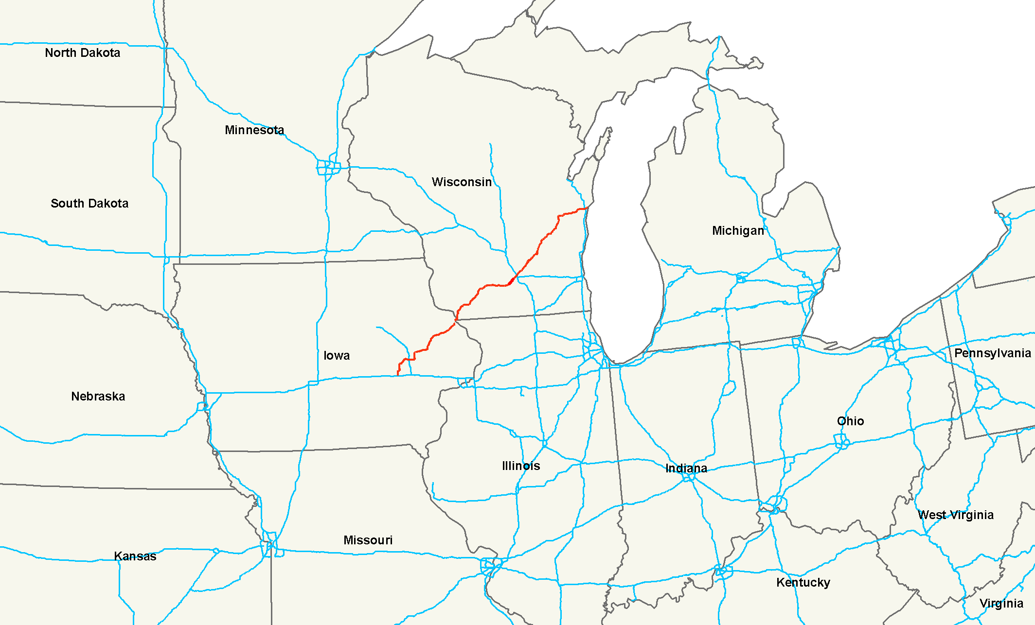
length_mi=337Droz, Robert V. [http://www.us-highways.com/usbt.htm U.S. Highways : From US 1 to (US 830)] . URL accessed 02:55, 4 July 2006 (UTC).]
length_km=542
yrcom=1926
direction_a=South
direction_b=North
from=jct|state=IA|I|80 nearWilliamsburg, IA
junction=Jct|state=IA|US|30 inCedar Rapids, IA
jct|state=IA|US|20 inDubuque, IA
jct|state=WI|I|39|I|90|I|94 inMadison, WI
jct|state=WI|US|41 inFond du Lac, WI
jct|state=WI|I|43 inManitowoc, WI
to=Jct|state=WI|US|10 inManitowoc, WI
spur_of=51
commons=categoryU.S. Route 151 is a
U.S. Highway that runs through the states ofIowa andWisconsin . The northern terminus for U.S. 151 is atManitowoc, Wisconsin , and its southern terminus is at a junction withInterstate 80 inIowa County, Iowa . The route, from south to north follows a northeasterly path through Iowa and Wisconsin.Approximately seven miles (11 km) south of
Dubuque, Iowa , U.S. 151 joins withU.S. Highway 61 . The two highways share a route from there toDickeyville, Wisconsin . Three miles (5 km) south of Dubuque, U.S. 61/151 join withU.S. Highway 52 , and share a route with U.S. 52 until the White Street exit in Dubuque.In Wisconsin, U.S. 61/151 joins with Highway 35 about one mile (1.6 km) north of the Iowa/Wisconsin border. At Dickeyville, U.S. 151 splits off and heads northeast to Platteville. U.S. 61 and Highway 35 continue north. U.S. 151 later joins with
U.S. Highway 18 nearDodgeville, Wisconsin . The two highways share a route all the way toMadison, Wisconsin .Route description
Iowa
U.S. 151 begins at
Interstate 80 exit 225, approximately 20 miles (32 kilometers) west of Iowa City. The route traverses northeast through theAmana Colonies towards Cedar Rapids where it joinsU.S. 30 eastbound and bypasses the city. The route passes Anamosa, Monticello and Cascade on the way to Dubuque, where it joinsU.S. 61 and crosses theMississippi River into Wisconsin.Route upgrades
In 2000, construction began along the Iowa sections of U.S. 151 between Cedar Rapids and Dubuque. By the end of 2001, the four lane sections from Marion to Anamosa were completed. By 2002, the bypass around Cascade was completed. By the summer of 2004, the Monticello bypass was opened, as was most of the remaining segments of highway. The last major portion of the highway - a 16 mile (26 km) section between Cascade and about two miles (3 km) south of the intersection with U.S. 61 still under construction—was completed in the summer of 2004. The two new southbound lanes were opened on
September 13 ,2004 .Wisconsin
U.S. 151 enters at the corner of Iowa,
Illinois and Wisconsin and heads northeastward towards Dodgeville. U.S. 61 leaves the route about 8 miles into Wisconsin at Dickeyville.U.S. 18 joins the route at Dodgeville and they continue eastward together into Madison. The route follows the Madison Beltline for 3 miles before turning of and through downtown Madison. Upon departure from Madison, U.S. 151 heads northeastward to Fond du Lac and Manitowoc where it ends in downtown Manitowoc.History
U.S. 151 was one of the original highways from
1926 . At the time, it only ran fromFond du Lac, Wisconsin to Madison. Originally, the highway ended at Western Avenue and Main Street in Madison. In 1934, the highway was southwest extended toCedar Rapids, Iowa , incorporating the full length of former U.S. Route 118 (Dodgeville to Dickeyville) and part of formerU.S. Route 161 (Dubuque to Cedar Rapids; US 161 from Cedar Rapids south to Keokuk becameU.S. Route 218 ). At the time, the southern end of the route was at Williams Blvd SW and 16th Ave SW, what was then U.S. Highways 30 and 218. In the 1940s, the highway was extended northeast to Manitowoc.In 1969, the
Eagle Point Bridge , which connected U.S. 151 and U.S. 61 with Wisconsin, was closed and those highways were rerouted over theJulien Dubuque Bridge withU.S. Route 20 from Dubuque toEast Dubuque, Illinois . The route then followedIllinois Route 35 andWisconsin Highway 35 north to what is now the current highway. In 1982, theDubuque-Wisconsin Bridge opened, the old Eagle Point Bridge was demolished, and U.S. 151 and U.S. 61 was rerouted onto the new bridge.In 1981, the southern terminus of the highway was extended once again when the U.S. 30 bypass was built. The southern terminus was at the US 151 and 30 interchange. By 1986, the main U.S. 151 was rerouted onto state highway 13 and U.S. Highway 30 to bypass Cedar Rapids. The previous route through Cedar Rapids was renamed as Business U.S. 151 (though the official state designation for it is State Route 922). Finally in 1989, U.S. 151 was extended to its current southern terminus at Interstate 80, exit 225. This extension followed the route of the former state highway 149. As a result, U.S. 151 became the main route through the Amana Colonies.
ee also
*
List of U.S. Routes
*U.S. Route 51
*Bannered routes of U.S. Route 151 References
###@@@KEYEND@@@###
Wikimedia Foundation. 2010.