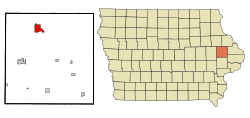
- Monticello, Iowa
-
Monticello, Iowa — City — Location of Monticello, Iowa Coordinates: 42°14′20″N 91°11′21″W / 42.23889°N 91.18917°WCoordinates: 42°14′20″N 91°11′21″W / 42.23889°N 91.18917°W Country  United States
State  Iowa
IowaCounty Jones Area – Total 3.7 sq mi (9.6 km2) – Land 3.7 sq mi (9.5 km2) – Water 0.0 sq mi (0.1 km2) Elevation 823 ft (251 m) Population (2010)[1] – Total 3,796 – Density 1,025.9/sq mi (396.1/km2) Time zone Central (CST) (UTC-6) – Summer (DST) CDT (UTC-5) ZIP code 52310 Area code(s) 319 FIPS code 19-53625 GNIS feature ID 0459195 Website City Website Monticello is a city in Jones County, Iowa, United States. As of the 2010 census, the city population was 3,796.[1] It is part of the Cedar Rapids Metropolitan Statistical Area.
Contents
Geography
Monticello is located at 42°14′20″N 91°11′21″W / 42.23889°N 91.18917°W (42.238759, -91.189067)[2]. According to the United States Census Bureau, the city has a total area of 3.7 square miles (9.6 km²), of which, 3.7 square miles (9.5 km²) of it is land and 0.04 square miles (0.1 km²) of it (0.54%) is water.
For many years, U.S. Highway 151 went directly through Monticello. In 2004, a four lane bypass around Monticello was completed and opened. As a result, the highway was moved about a mile south of the previous route.[citation needed]
Demographics
Historical populations Census Pop. %± 1970 3,509 — 1980 3,641 3.8% 1990 3,522 −3.3% 2000 3,607 2.4% 2010 3,796 5.2% U.S. Decennial Census As of the census[3] of 2000, there were 3,607 people, 1,538 households, and 979 families residing in the city. The population density was 980.8 people per square mile (378.4/km²). There were 1,637 housing units at an average density of 445.1 per square mile (171.8/km²). The racial makeup of the city was 98.75% White, 0.19% African American, 0.08% Native American, 0.14% Asian, 0.17% from other races, and 0.67% from two or more races. Hispanic or Latino of any race were 1.16% of the population.
There were 1,538 households out of which 26.9% had children under the age of 18 living with them, 51.4% were married couples living together, 9.4% had a female householder with no husband present, and 36.3% were non-families. 31.5% of all households were made up of individuals and 17.4% had someone living alone who was 65 years of age or older. The average household size was 2.26 and the average family size was 2.82.
In the city the population was spread out with 23.1% under the age of 18, 7.3% from 18 to 24, 24.5% from 25 to 44, 21.3% from 45 to 64, and 23.8% who were 65 years of age or older. The median age was 42 years. For every 100 females there were 85.0 males. For every 100 females age 18 and over, there were 82.2 males.
The median income for a household in the city was $34,932, and the median income for a family was $42,616. Males had a median income of $30,324 versus $20,998 for females. The per capita income for the city was $16,699. About 3.6% of families and 7.2% of the population were below the poverty line, including 5.8% of those under age 18 and 6.7% of those age 65 or over.
Notable people
- Samuel Charles Black (1869–1921) fifth president of Washington & Jefferson College [4]
- Ellen Dolan, television actress, most notably in Guiding Light and As the World Turns
- Charles W. Gurney, Lieutenant Colonel during the American Civil War and founder of Gurney's Seed and Nursery Company
- Charles Henry Sloan, former Nebraska politician
References
- ^ a b "2010 City Population and Housing Occupancy Status". U.S. Census Bureau. http://factfinder2.census.gov/faces/tableservices/jsf/pages/productview.xhtml?pid=DEC_10_PL_GCTPL2.ST13&prodType=table. Retrieved March 6, 2011.
- ^ "US Gazetteer files: 2010, 2000, and 1990". United States Census Bureau. 2011-02-12. http://www.census.gov/geo/www/gazetteer/gazette.html. Retrieved 2011-04-23.
- ^ "American FactFinder". United States Census Bureau. http://factfinder.census.gov. Retrieved 2008-01-31.
- ^ "Samuel Charles Black (1919-1921)". CONTENTdm. http://washjeff.cdmhost.com/cdm4/item_viewer.php?CISOROOT=/p4019coll8&CISOPTR=35. Retrieved March 11, 2011.
External links
Municipalities and communities of Jones County, Iowa Cities Anamosa | Cascade‡ | Center Junction | Martelle | Monticello | Morley | Olin | Onslow | Oxford Junction | Wyoming
Unincorporated
communitiesAmber | Fairview | Hale | Langworthy | Oxford Mills | Scotch Grove | Stone City | Temple Hill
Footnotes ‡This populated place also has portions in an adjacent county or counties
Categories:- Cities in Iowa
- Populated places in Jones County, Iowa
- Cedar Rapids metropolitan area
Wikimedia Foundation. 2010.

