- Muscatine County, Iowa
-
Muscatine County, Iowa  Muscatine County Courthouse in Muscatine
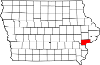
Location in the state of Iowa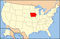
Iowa's location in the U.S.Founded December 7, 1836 Seat Muscatine Area
- Total
- Land
- Water
449.07 sq mi (1,163 km²)
438.67 sq mi (1,136 km²)
10.40 sq mi (27 km²), 2.32%Population
- (2010)
- Density
42,745
100/sq mi (38/km²)Time zone Central: UTC-6/-5 Website www.co.muscatine.ia.us Footnotes: Population [1] Muscatine County is a county located in the U.S. state of Iowa. The population was 42,745 in the 2010 census, an increase from 41,722 in the 2000 census.[1][2] The county seat is Muscatine.[3]
Muscatine County is part of the Muscatine Micropolitan Statistical Area.
Contents
Geography
According to the 2000 census, the county has a total area of 449.07 square miles (1,163.1 km2), of which 438.67 square miles (1,136.2 km2) (or 97.68%) is land and 10.40 square miles (26.9 km2) (or 2.32%) is water.[4]
Major highways
 U.S. Highway 6
 U.S. Highway 61
 Iowa Highway 22
 Iowa Highway 38
Other roadways
County highways
- County Highway F58
- County Highway F70
- County Highway G28
- County Highway G38
- County Highway X61
Adjacent counties
- Cedar County (north)
- Scott County (northeast)
- Rock Island County, Illinois (east), across the Mississippi River
- Louisa County (south)
- Johnson County (northwest)
History
Muscatine County was formed on December 7, 1836. One history of the county claims it was named for Muscatine Island in the Mississippi River.[5] The island lies opposite Muscatine County and was allegedly named after the Mascouten native American tribe members who formerly lived there.[5]
In 1833, Colonel George Davenport of Illinois sent three representatives into the territory for the purpose of establishing a trade post. These were the first whites to maintain residency here. In the same year, James W. Casey and John Vanatta came to the area. They opened a supply depot for steamships in the area on June 1, 1833, named Casey’s Woodpile. The first public land sale was held in November, 1838. One year later, the construction of the courthouse and a jail was begun.
On December 23, 1864, the courthouse was complete gutted by a fire and within two years a new structure was completed on the same site. The construction of the courthouse still used today was completed on September 26, 1907.[6]
Demographics
Historical populations Census Pop. %± 1850 5,731 — 1860 16,444 186.9% 1870 21,688 31.9% 1880 23,170 6.8% 1890 24,504 5.8% 1900 28,242 15.3% 1910 29,505 4.5% 1920 29,042 −1.6% 1930 29,385 1.2% 1940 31,296 6.5% 1950 32,148 2.7% 1960 33,840 5.3% 1970 37,181 9.9% 1980 40,436 8.8% 1990 39,907 −1.3% 2000 41,722 4.5% 2010 42,745 2.5% Iowa Data Center [2] 2010 census
The 2010 census recorded a population of 42,745 in the county, with a population density of 99.7154/sq mi (38.5003/km2). There were 17,910 housing units, of which 16,412 were occupied.[1]
2000 census
 2000 Census Age Pyramid for Adair County
As of the census[7] of 2000, there were 41,722 people, 15,847 households, and 11,283 families residing in the county. The population density was 95 people per square mile (37/km²). There were 16,786 housing units at an average density of 38 per square mile (15/km²). The racial makeup of the county was 90.72% White, 0.70% Black or African American, 0.31% Native American, 0.83% Asian, 0.02% Pacific Islander, 6.05% from other races, and 1.37% from two or more races. 11.92% of the population were Hispanic or Latino of any race.
There were 15,847 households out of which 34.80% had children under the age of 18 living with them, 57.90% were married couples living together, 9.30% had a female householder with no husband present, and 28.80% were non-families. 24.10% of all households were made up of individuals and 9.90% had someone living alone who was 65 years of age or older. The average household size was 2.59 and the average family size was 3.07.
In the county the population was spread out with 26.90% under the age of 18, 8.60% from 18 to 24, 28.80% from 25 to 44, 22.80% from 45 to 64, and 12.90% who were 65 years of age or older. The median age was 36 years. For every 100 females there were 98.10 males. For every 100 females age 18 and over, there were 94.90 males.
The median income for a household in the county was $41,803, and the median income for a family was $48,373. Males had a median income of $36,329 versus $24,793 for females. The per capita income for the county was $19,625. About 6.30% of families and 8.90% of the population were below the poverty line, including 10.70% of those under age 18 and 7.70% of those age 65 or over.
Communities

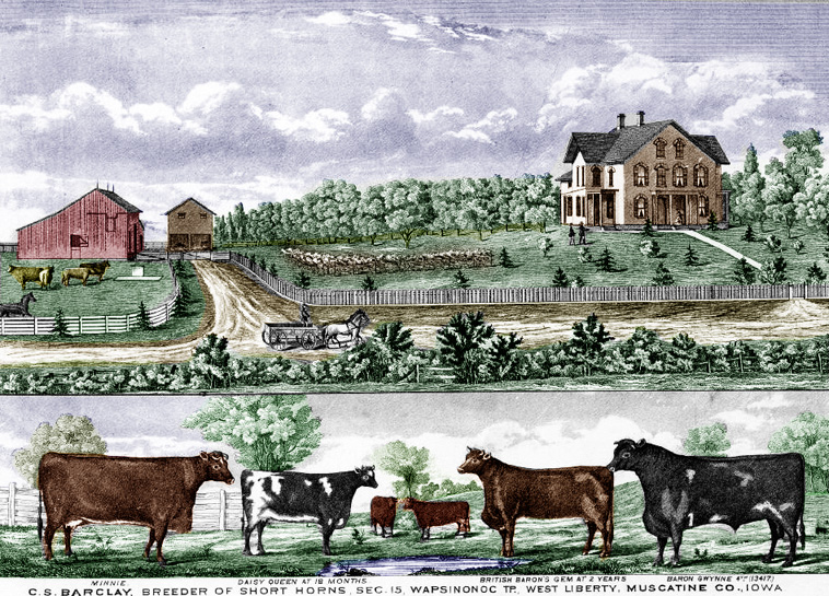
C.S. Barclay farm illustration in 1875 Cities
- Atalissa
- Blue Grass (part)
- Durant (part)
- Conesville
- Fruitland
- Muscatine
- Nichols
- Stockton
- Walcott (part)
- West Liberty
- Wilton
Unincorporated communities
See also
Notes
- ^ a b c "Population & Housing Occupancy Status 2010". United States Census Bureau American FactFinder. http://factfinder2.census.gov/faces/tableservices/jsf/pages/productview.xhtml?pid=DEC_10_PL_GCTPL2.ST05&prodType=table. Retrieved May 19, 2011.
- ^ a b "Data from the 2010 Census". State Data Center of Iowa. http://www.iowadatacenter.org/archive/2011/02/feb10. Retrieved May 19, 2011.
- ^ "Find a County". National Association of Counties. http://www.naco.org/Counties/Pages/FindACounty.aspx. Retrieved 2011-06-07.
- ^ "Census 2000 U.S. Gazetteer Files: Counties". United States Census. http://www.census.gov/tiger/tms/gazetteer/county2k.txt. Retrieved 2011-02-13.
- ^ a b History Section, 1879, History of Muscatine County Iowa, http://iagenweb.org/muscatine/biographies1879/thename.htm, retrieved 11 May 2009
- ^ History
- ^ "American FactFinder". United States Census Bureau. http://factfinder.census.gov. Retrieved 2008-01-31.
External links

Cedar County Scott County Johnson County 
Rock Island County, Illinois  Muscatine County, Iowa

Louisa County Municipalities and communities of Muscatine County, Iowa Cities Atalissa | Blue Grass‡ | Conesville | Durant‡ | Fruitland | Muscatine | Nichols | Stockton | Walcott‡ | West Liberty | Wilton

Unincorporated
communitiesArdon | Cranston | Fairport | Hinkeyville | Montpelier | Moscow | Petersburg
Footnotes ‡This populated place also has portions in an adjacent county or counties
Coordinates: 41°28′52″N 91°07′11″W / 41.48111°N 91.11972°W
Categories:- Iowa counties
- Muscatine County, Iowa
- 1836 establishments in the United States
- Populated places established in 1836
- Muscatine micropolitan area
- Iowa counties on the Mississippi River


Wikimedia Foundation. 2010.