- Decatur County, Iowa
-
Decatur County, Iowa 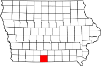
Location in the state of Iowa
Iowa's location in the U.S.Founded 1846 Seat Leon Area
- Total
- Land
- Water
533.32 sq mi (1,381 km²)
531.80 sq mi (1,377 km²)
1.52 sq mi (4 km²), 0.29%Population
- (2010)
- Density
8,457
16/sq mi (6/km²)Time zone Central: UTC-6/-5 Footnotes: Population [1] Decatur County is a county located in the U.S. state of Iowa. The population was 8,457 in the 2010 census, a decline from 8,689 in the 2000 census.[1][2] The county seat is Leon.[3] This county is named for Stephen Decatur, Jr., a hero in the War of 1812.
Contents
Geography
According to the 2000 census, the county has a total area of 533.32 square miles (1,381.3 km2), of which 531.80 square miles (1,377.4 km2) (or 99.71%) is land and 1.52 square miles (3.9 km2) (or 0.29%) is water.[4]
Major highways
 Interstate 35
 U.S. Highway 69
 Iowa Highway 2
Adjacent counties
- Clarke County (north)
- Wayne County (east)
- Mercer County, Missouri (southeast)
- Harrison County, Missouri (southwest)
- Ringgold County (west)
Demographics
Historical populations Census Pop. %± 1850 965 — 1860 8,677 799.2% 1870 12,018 38.5% 1880 15,336 27.6% 1890 15,643 2.0% 1900 18,115 15.8% 1910 16,347 −9.8% 1920 16,566 1.3% 1930 14,903 −10.0% 1940 14,012 −6.0% 1950 12,601 −10.1% 1960 10,539 −16.4% 1970 9,737 −7.6% 1980 9,794 0.6% 1990 8,338 −14.9% 2000 8,689 4.2% 2010 8,457 −2.7% Iowa Data Center [2] 2010 census
The 2010 census recorded a population of 8,457 in the county, with a population density of 15.897/sq mi (6.138/km2). There were 3,834 housing units, of which 3,223 were occupied.[1]
2000 census
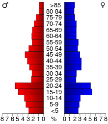 2000 Census Age Pyramid for Decatur County.
As of the census [5] of 2000, there were 8,689 people, 3,337 households, and 2,149 families residing in the county. The population density was 16 people per square mile (6/km²). There were 3,833 housing units at an average density of 7 per square mile (3/km²). The racial makeup of the county was 96.46% White, 0.98% Black or African American, 0.24% Native American, 0.63% Asian, 0.12% Pacific Islander, 0.46% from other races, and 1.12% from two or more races. 1.70% of the population were Hispanic or Latino of any race.
There were 3,337 households out of which 28.00% had children under the age of 18 living with them, 54.30% were married couples living together, 7.20% had a female householder with no husband present, and 35.60% were non-families. 30.30% of all households were made up of individuals and 15.50% had someone living alone who was 65 years of age or older. The average household size was 2.37 and the average family size was 2.96.
In the county the population was spread out with 23.00% under the age of 18, 16.30% from 18 to 24, 21.60% from 25 to 44, 21.50% from 45 to 64, and 17.70% who were 65 years of age or older. The median age was 36 years. For every 100 females there were 95.70 males. For every 100 females age 18 and over, there were 91.90 males.
The median income for a household in the county was $27,343, and the median income for a family was $34,831. Males had a median income of $25,569 versus $19,309 for females. The per capita income for the county was $14,209. About 10.90% of families and 15.50% of the population were below the poverty line, including 15.60% of those under age 18 and 13.70% of those age 65 or over.
Decatur County is considered to be the poorest in Iowa, reporting that almost 20% of its residents live in poverty.
Localities
Cities
Townships
Decatur County is divided into these townships:
See also
- Decatur County Courthouse (Iowa)
- National Register of Historic Places listings in Decatur County, Iowa
References
- ^ a b c "Population & Housing Occupancy Status 2010". United States Census Bureau American FactFinder. http://factfinder2.census.gov/faces/tableservices/jsf/pages/productview.xhtml?pid=DEC_10_PL_GCTPL2.ST05&prodType=table. Retrieved May 8, 2011.
- ^ a b "Data from the 2010 Census". State Data Center of Iowa. http://www.iowadatacenter.org/archive/2011/02/feb10. Retrieved May 8, 2011.
- ^ "Find a County". National Association of Counties. http://www.naco.org/Counties/Pages/FindACounty.aspx. Retrieved 2011-06-07.
- ^ "Census 2000 U.S. Gazetteer Files: Counties". United States Census. http://www.census.gov/tiger/tms/gazetteer/county2k.txt. Retrieved 2011-02-13.
- ^ "American FactFinder". United States Census Bureau. http://factfinder.census.gov. Retrieved 2008-01-31.
External links

Clarke County Ringgold County 
Wayne County  Decatur County

Harrison County Mercer County Municipalities and communities of Decatur County, Iowa Cities Davis City | Decatur City | Garden Grove | Grand River | Lamoni | Leon | Le Roy | Pleasanton | Van Wert | Weldon

Townships Bloomington | Burrell | Center | Decatur | Eden | Fayette | Franklin | Garden Grove | Grand River | Hamilton | High Point | Long Creek | Morgan | New Buda | Richland | Woodland
Coordinates: 40°44′29″N 93°46′51″W / 40.74139°N 93.78083°W
Categories:- Iowa counties
- Decatur County, Iowa
- 1846 establishments in the United States


Wikimedia Foundation. 2010.