- U.S. Route 218
-
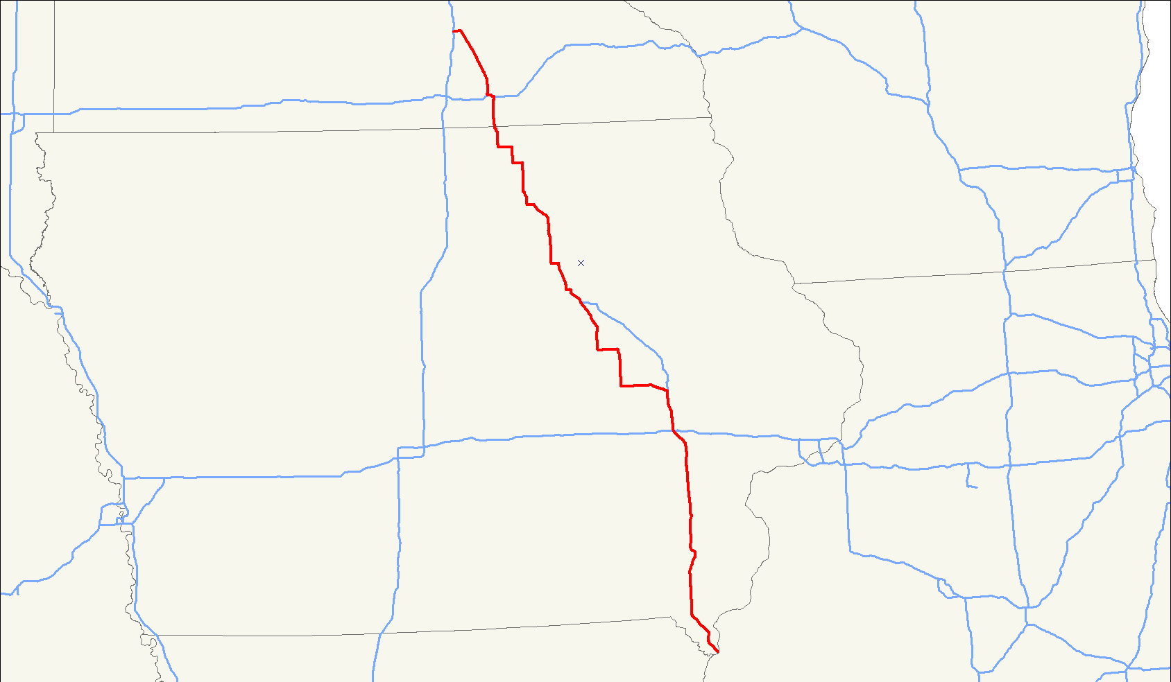
U.S. Route 218
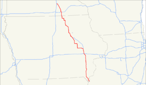
Route information Length: 319 mi[2] (513 km)
Iowa:272 mi (438 km)
Minnesota:47 mi (76 km)Existed: 1926[1] – present Major junctions South end:  US 136 at Keokuk, IA
 US 34 at Mount Pleasant, IA

 I-80 / I-380 at Coralville, IA

 I-380 / US 30 / US 151 in Cedar Rapids, IA
 I-380 / US 20 at Waterloo, IA
 US 18 at Floyd, IA
 I-90 at Austin, MN
North end: 
 I-35 / US 14 at Owatonna, MN
Highway system United States Numbered Highways
List • Bannered • Divided • Replaced←  Iowa 212
IA Iowa 220  →
→←  MN 217
MN MN 219  →
→U.S. Route 218 is an original United States Highway, created in 1926. Although technically a spur of U.S. Route 18, US 218 neither begins nor ends at US 18, but overlaps US 18 for 8 miles (13 km) near Charles City, Iowa. US 218 begins at U.S. Route 136 in downtown Keokuk and ends 319 miles (513 km) away at Interstate 35 and U.S. Route 14 at Owatonna, Minnesota. A large portion of US 218 in Iowa is part of the Avenue of the Saints, which connects St. Louis, Missouri, and St. Paul, Minnesota.
Contents
Route description
Iowa
U.S. 218 is part of the Avenue of the Saints between Floyd and Cedar Falls, and again between Cedar Rapids and a point south of Donnellson. North of Mount Pleasant, the parts of US 218 that follow the Avenue have been completely upgraded to four lanes, with either at-grade intersections or controlled access. When 218 is part of the Avenue of the Saints, it is co-signed with Iowa Highway 27.
Minnesota
U.S. 218 enters the state at Lyle, in Mower County. It follows along the east side of the Iowa, Chicago, and Eastern Railroad line as it continues northward through farm fields. Southeast of Austin, U.S. 218 angles northeastward to bypass the city, its former route following County Road 45 into town.[3]
U.S. 218 passes by the Austin Municipal Airport just before its interchange with Interstate 90. The highway runs concurrent with I-90 for nearly three miles through northern Austin. When U.S. 218 departs from the interstate and turns back north, it becomes a four-lane divided highway for a short time. After its junction with State Highway 251, the highway angles north-northwestward again following the IC&E rail line, this time on the west side of the tracks.[3]
The highway enters Dodge County for less than a mile, then reaches Steele County, Blooming Prairie, and an 8-block-long concurrency with State Highway 30. It continues north-northwest after leaving Blooming Prairie, traveling through predominantly agricultural scenery. It passes by Oak Glen Lake before going through the unincorporated town of Bixby.
After passing through the town of Pratt, U.S. 218 meets U.S. 14 at a folded diamond interchange. 218 runs westward concurrent with 14, while it's historic route through downtown Owatonna continues ahead as County Road 48. After an interchange with County Road 45 (former U.S. 65), 218 and 14 pass by Kaplan's Woods Park and reach Interstate 35, where U.S. 218 ends.
Legally, the Minnesota section of U.S. 218 is defined as Route 40 in Minnesota Statutes § 161.114(2).[4]
History
In 1913, work on the road that is now U.S. 218 was begun. At this time it was called the Red Ball Route. It was called this because the original route was marked with poles which had red balls, six inches in diameter, mounted on each side. In 1920, the Minnesota portion of the route was designated as Constitutional Route 40, as part of the Babcock Amendment that established the Minnesota trunk highway system.
In Iowa, U.S. 218 was extended from its previous southern terminus, at its intersection with U.S. 30 in Benton County, in 1934 when U.S. Route 161 was split and renamed. The former U.S. 161 had extended from Dubuque, through Cedar Rapids, to Keokuk. After the split, the section of former U.S. 161 from Dubuque to Cedar Rapids extended U.S. 151 south, and the section of U.S. 30 from the former terminus of U.S. 218 to its intersection with the former U.S. 161 in Cedar Rapids, along with the section of former U.S. 161 from Cedar Rapids to Keokuk, extended U.S. 218 south.
In 1965, U.S. 218 was rerouted along bypasses of Austin, Minnesota and Owatonna, Minnesota,[5][6] the latter following a route that would later become the U.S. 14 bypass of that city as well.
Major intersections
Iowa
County Location Mile[7] Exit[8] Destinations Notes Lee Keokuk 0.000 

 US 136 west / US 61 Bus. south (7th Street) / US 136 east (Main Street)
South end of US 61 Bus. overlap 3.480
US 61 south / US 61 Bus. southSouth end of US 61 overlap; north end of US 61 Bus. Montrose Township 9.132 US 61 northNorth end of US 61 overlap Charleston Township 18.746 18  Iowa 27 south – St. Louis
South end of Iowa 27 overlap Donnellson 20.673 19  Iowa 2 – Donnellson, Fort Madison
Marion Township 30.760  Iowa 16
Henry Mount Pleasant 41.663 40 255th Street – Mount Pleasant 43.349 42A  US 34 east / Iowa 163 east – Burlington
South end of US 34 overlap 43.349 42B
 US 218 Bus. – Mount Pleasant
45.787 45 US 34 west / Iowa 163 west – Mount Pleasant, OttumwaNorth end of US 34 overlap; northbound exit and southbound entrance only 47.223 45
US 218 Bus. (IA 438) to US 34 west – Mount Pleasant, OttumwaSouthbound exit and northbound entrance only Olds 55.447  Iowa 78
Washington Oregon Township 67.581 66  Iowa 92 – Washington, Columbus Junction
70.960 70  CR G36
Riverside 81.072 80  Iowa 22 – Kalona, Lone Tree
Johnson Liberty Township 85.534 85 Hills West Lucas Township 89.708 89 Riverside Drive, Airport Iowa City 91.318  Iowa 1 – Iowa City, Kalona
93.561 93 Melrose Avenue – University Heights Coralville 96.934 0† I-80 / I-380 north – Davenport, Des MoinesSouthern end of I-380; Southbound exits signed 0A (eastbound) and 0B (westbound) North Liberty 100.980 4†  CR F28 – North Liberty
Shueyville 107.791 10†  CR F12 – Swisher, Shueyville
Linn Cedar Rapids 110.750 13† Wright Brothers Boulevard SW – Ely, The Eastern Iowa Airport 113.263 16A† US 30 east / US 151 northSouth end of US 30 / US 151 overlap I-380 north / Iowa 27 northNorth end of I-380 / IA 27 overlap 113.596 252A‡ 6th Street SW 115.780 250‡ Edgewood Road SW 117.151 248‡
US 151 south / US 151 Bus. (Williams Boulevard SW)North end of US 151 overlap Clinton Township 119.130 246‡ 16th Avenue / 80th Street – Fairfax Northbound exit and southbound entrance only 119.651 246‡ 16th Avenue / 80th Street – Fairfax Southbound exit and northbound entrance only Benton Eldorado Township 135.239 US 30 westEnd of US 30 overlap Vinton 148.199  Iowa 150 north
Monroe Township 158.602  Iowa 8 west
Black Hawk Waterloo 179.468 71† I-380 south / US 20 / Iowa 27 – Cedar Falls, Cedar Rapids, DubuqueSouth end of I-380 overlap; Signed 71A (eastbound) and 71B (westbound) 180.535 72† San Marnan Drive 181.116 I-380 southNorth end of I-380 182.864–183.102 SB: 180
NB: 181A US 63 north – Downtown Riverfront, Young Arena, Sullivan Brothers Convention Center
No northbound entrance 183.425 181B US 63 south to University AvenueNo southbound entrance; Signed Exit 181 southbound 184.201–184.785 182 Fletcher Avenue, Ansborough Avenue 185.659 184 Greenhill Road 187.228 185 Broadway Street, Airport Cedar Falls 189.067 
 Iowa 27 south / Iowa 57 west / Iowa 58 south – Cedar Falls, Hudson, UNI, UNI-Dome
South end of IA 27 overlap 190.719 189 Lone Tree Road Bremer Waverly 200.256 198
US 218 Bus. – Waverly204.757 203  Iowa 3 – Waverly, Shell Rock
206.757 205
US 218 Bus. – Waverly AirportPlainfield 214.012 212  Iowa 188 – Plainfield
Chickasaw Nashua 221.316 220 
 Iowa 346 / CR B60 – Nashua
Floyd Charles City 230.538 218§
 US 18 east / US 218 Bus. / CR T64 – Charles City, New Hampton
South end of US 18 overlap 234.114 214§  Iowa 14 – Charles City, Greene
236.238 212§
 US 218 Bus. / CR B35 – Charles City
Floyd 238.655 US 18 west / Iowa 27 northNorth end of US 18 / IA 27 overlap Mitchell Burr Oak Township 249.987  Iowa 9 east
South end of IA 9 overlap Osage 253.985 Iowa 9 westNorth end of IA 9 overlap St. Ansgar 265.754  CR 105
Otranto Township 274.995  US 218 north
1.000 mi = 1.609 km; 1.000 km = 0.621 mi
Concurrency terminus • Closed/Former • Incomplete access • Unopened- † Exit numbers follow Interstate 380
- ‡ Exit numbers follow U.S. Route 30
- § Exit numbers follow U.S. Route 18
Minnesota
County Location Mile[9] Destinations Notes Mower Lyle 0.000 US 218 southAustin 12.183 I-90East end of I-90 overlap I-90: 180.116-180.204 Oakland Place Westbound exit and eastbound entrance I-90: 179.318-179.581 11th Drive NE Interchange I-90: 178.557-178.960  CR 16 (6th Street NE)
Interchange I-90: 178.016-178.346  CR 45 (4th Street NW)
Interchange 14.988 I-90West end of I-90 overlap Lansing Township 20.556  MN 251
Dodge No major junctions Steele Blooming Prairie 28.822  MN 30
MN 30South end of MN 30 overlap 29.360 MN 30North end of MN 30 overlap Owatonna Township 43.648 US 14East end of US 14 overlap US 14: 174.731-175.118  CR 45
CR 45Interchange, old U.S. 65 46.670 I-35Interchange 1.000 mi = 1.609 km; 1.000 km = 0.621 mi
Concurrency terminus • Closed/Former • Incomplete access • UnopenedRelated routes
Mount Pleasant business route

U.S. Route 218 Business
Location: Mount Pleasant Existed: 2003–present U.S. Route 218 Business was designated along a former routing of US 218 through Mount Pleasant, the northernmost 0.7 miles (1.1 km) are officially known as Iowa Highway 438. The routing was created as a result of construction of the Avenue of the Saints corridor through Iowa.[10] The new Avenue of the Saints corridor took US 218 / IA 27 and U.S. Route 34 around the eastern and northern edges of Mount Pleasant. The Iowa 438 section of US 218 Business serves as a connector from southbound US 218/IA 27 to westbound US 34.
Waverly business route
U.S. Route 218 BusinessLocation: Waverly Length: 6.6 mi[11] (10.6 km) Existed: December 1998–present U.S. Route 218 Business was designated December 2, 1998 on the old segment of US 218 after it was routed around Waverly, spanning 6.6 miles (10.6 km). It intersects Iowa Highway 3 in downtown Waverly and runs concurrently for about one mile.[11] South of Iowa Highway 3, U.S. Route 218 Business is officially known as Iowa Highway 116.[12] U.S. Route 218 Business begins at exit 198 of US 218 / IA 27 south of Waverly and ends at exit 205 of US 218 / IA 27.
Charles City business route
U.S. Route 218 BusinessLocation: Charles City Existed: 2000–present U.S. Route 218 Business was designated along the old alignment of US 218 in 2000 after the construction of the Avenue of the Saints corridor created a bypass around Charles City. Upon its designation, the route was officially known by two Iowa state highways – Iowa Highway 337 and Iowa Highway 162. Iowa 337 was deleted in 2001 and Iowa 162 was deleted in 2006 after US 18 was relocated through Charles City.
Browse numbered routes ←  Iowa 415
IA 438 Iowa 922  →
→←  Iowa 110
IA 116 Iowa 117  →
→References
- ^ US Highways.com
- ^ "United States Numbered Highways". AASHTO. 1989 Edition. http://cms.transportation.org/?siteid=68&pageid=1760. Retrieved 24 December 2009.
- ^ a b Minnesota Department of Transportation (2010). General Highway Map of Mower County, Minnesota (Map). http://www.dot.state.mn.us/maps/cadd/county/mower.pdf. Retrieved December 29, 2010.
- ^ Minnesota Codified Laws
- ^ Minnesota Department of Highways (1965). 1965 Official Road Map of Minnesota (Map). Section J20-K21. http://reflections.mndigital.org/cdm4/document.php?CISOROOT=/mdt&CISOPTR=1213&REC=4. Retrieved January 25, 2010.
- ^ Minnesota Department of Highways (1966). 1966 Official Road Map of Minnesota (Map). Section J20-K21. http://reflections.mndigital.org/cdm4/document.php?CISOROOT=/mdt&CISOPTR=1216&REC=5. Retrieved January 25, 2010.
- ^ "2010 Volume of Traffic on the Primary Road System of Iowa" (PDF). Iowa Department of Transportation. January 1, 2010. http://www.iowadotmaps.com/trafbook/trafbook2010.pdf. Retrieved November 20, 2010.
- ^ Iowa Department of Transportation (2010). Transportation Map (Map). http://www.iowadotmaps.com/msp/pdf/current/stmapmain.pdf. Retrieved November 21, 2010.
- ^ "Trunk Highway Log Point Listing - Construction District 6" (PDF). Minnesota Department of Transportation. August 23, 2010. http://www.dot.state.mn.us/roadway/data/reports/logpoint/d6.pdf. Retrieved November 21, 2010.
- ^ Hancock, Jason (30 August 2009). "Iowa Highways: 400 to 478". The Iowa Highways Page. http://iowahighways.home.mchsi.com/highways/iowa400-475.html#438. Retrieved 17 March 2009.
- ^ a b Google, Inc. Google Maps – U.S. Route 218 (Map). Cartography by Google, Inc. http://maps.google.com.
- ^ Hancock, Jason (21 February 2007). "Iowa Highways: 100 to 119". The Iowa Highways Page. http://iowahighways.home.mchsi.com/highways/iowa100-119.html#116.
External links
 Main U.S. Routes
1 2 3 4 5 6 7 8 9 10 11 12 13 14 15 16 17 18 19 20 21 22 23 24 25 26 27 28 29 30 31 32 33 34 35 36 37 38 40 41 42 43 44 45 46 48 49 50 51 52 53 54 55 56 57 58 59 60 61 62 63 64 65 66 67 68 69 70 71 72 73 74 75 76 77 78 79 80 81 82 83 84 85 87 89 90 91 92 93 94 95 96 97 98 99 101 163 400 412 425 Lists U.S. Routes • Bannered • Divided • Bypassed Categories:- Three-digit U.S. Highways
- U.S. Highways in Iowa
- U.S. Highways in Minnesota

Wikimedia Foundation. 2010.