- Iowa Highway 1
Infobox road
state= IA
type= IOWA
route= 1
alternate_name=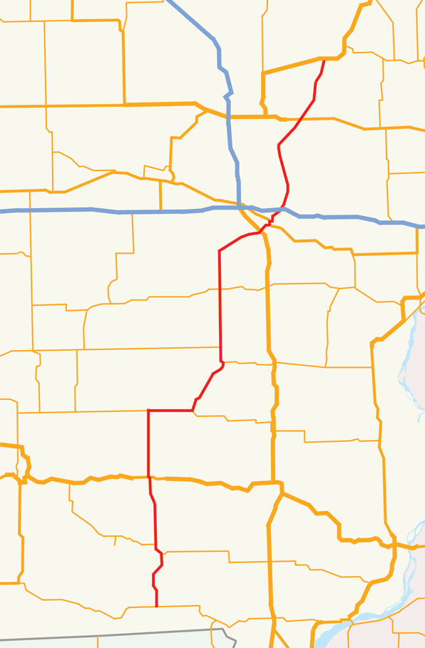
length_mi= 120
length_round=
length_ref= [http://iowahighways.home.mchsi.com/highways/iowa1-9.html#1a Iowa Highways: 1 to 9] ]
established= October 16, 1926
direction_a= South
starting_terminus= Jct|state=IA|IA|2|city1=Keosauqua
junction= Jct|state=IA|US|34|city1=Fairfield
Jct|state=IA|US|218|IA|27|city1=Iowa City
Jct|state=IA|I|80|city1=Iowa City
Jct|state=IA|US|30|city1=Mount Vernon
direction_b= North
ending_terminus= Jct|state=IA|US|151|city1=Anamosa
counties=Van Buren, Jefferson, Keokuk, Washington, Johnson Linn, Jones
cities=Keosauqua, Birmingham, Fairfield, Brighton, Washington, Kalona, Iowa City, Solon, Mount Vernon, Martelle
previous_type= Interstate
previous_route= 680
next_type= IOWA
next_route= 2Iowa Highway 1 is a state highway that runs from south to north in eastern
Iowa .Termini
The highway traverses 120 miles (193 kilometers) across Iowa, beginning south of Keosauqua. Its northern terminus is southwest of Anamosa at US 151. The northern terminus is an interchange.
Route description
Iowa Highway 1 begins south of Keosauqua at an intersection with
Iowa Highway 2 . It goes north into Keosauqua, crossing theDes Moines River and then runs concurrent briefly withIowa Highway 16 . They separate, and then Iowa 1 goes north through Birmingham and meetsU.S. Highway 34 in Fairfield. Iowa 1 goes due north out of Fairfield and turns east near Richland when it intersectsIowa Highway 78 . Iowa 1 and Iowa 78 run concurrently into Brighton, then Iowa 1 turns northeast. It continues northeast until Washington, where it intersectsIowa Highway 92 . Iowa 1 and Iowa 92 run together north out of Washington, and separate. Iowa 1 continues north through Kalona, where it meetsIowa Highway 22 . Iowa 1 continues north, then turns northeast to go through Iowa CityWhile in Iowa City, Iowa Highway 1 intersects
U.S. Highway 218 andIowa Highway 27 , then meetsU.S. Highway 6 near downtown Iowa City, where they run concurrently. Iowa 1 then turns east near theUniversity of Iowa campus to enter downtown Iowa City on Burlington Street. Iowa 1 then turns north on Dodge Street (southbound) and Governor Street (northbound), then leaves Iowa City on Dodge Street alone before meeting Interstate 80. Iowa 1 continues north through Solon, then turns northeast to go through Mount Vernon, where it intersectsU.S. Highway 30 . It continues on a northeasterly alignment through Martelle, then ends at a freeway interchange southwest of Anamosa withU.S. Highway 151 .History
The first Iowa Highway 1 was a north-south highway stretching from Northwood to Lamoni. It was designated on
July 1 ,1920 , but was replaced by US 65 and US 69 in 1926.The current highway was designated in 1926. Although no segments were paved at designation, the entire route was paved by 1969. The segment of Highway 1 from
Anamosa to Iowa City approximately follows part of the route of the territorial and military road from Dubuque to Iowa City. This road, authorized by PresidentMartin Van Buren in 1839, was known as Dillon's Furrow, named after the Dubuque merchant Lyman Dillon who surveyed the route and marked it with a furrow. [http://www.dot.state.ia.us/histbook.pdf Discovering historic Iowa transportation Milestones] Iowa Department of Transportation, circa 1999, page 5.] Most of the deviations of the route of Highway 1 from Dillon's original route are the result of road straightening or bypasses around town centers.In 2001, it was to become the first "Super-2" in Iowa (a two-lane road, but with wider shoulders and lanes, fewer intersections, and more turn lanes). Because of funding shortages, the project was scratched.
Currently, the highway has one closure. According to the
Iowa Department of Transportation :IA 1 in both directions: Road closed to traffic.Between Johnson County Road F28 and US 30. The road is closed to traffic, follow the detour signs, the route is impassable, due to storm damage until August 1.
Comment: Linn County: The road is closed from south of Hwy 30 to the City of Solon.Major intersections
Jctint
state=IA
county=Van Buren
cspan=3
location=Keosauqua
lspan=2
type=
mile=
road=Jct|state=IA|IA|2
notes=South terminusJctint
state=IA
type=mplex
mile=
road=Jct|state=IA|IA|16|dir1=East
notes=Jctint
state=IA
location=Birmingham
lspan=1
type=mplex
mile=
road=Jct|state=IA|IA|16|dir1=West
notes=Jctint
state=IA
county=Jefferson
location=Fairfield
lspan=1
type=mplex
mile=
road=Jct|state=IA|US|34|name1=Burlington Avenue
notes=Overlapped for one blockJctint
state=IA
county=Keokuk
location=Richland
lspan=1
type=mplex
mile=
road=Jct|state=IA|IA|78|dir1=West
notes=Jctint
state=IA
county=Washington
cspan=4
location=Brighton
lspan=
type=mplex
mile=
road=Jct|state=IA|IA|78|dir1=East
notes=Jctint
state=IA
location=Washington
lspan=2
type=mplex
mile=
road=Jct|state=IA|IA|92|dir1=East|name1=Madison Street
notes=Jctint
state=IA
type=mplex
mile=
road=Jct|state=IA|IA|92|dir1=West
notes=Jctint
state=IA
location=Kalona
lspan=1
type=
mile=
road=Jct|state=IA|IA|22|name1=E Avenue
notes=Jctint
state=IA
county=Johnson
cspan=6
location=Iowa City
lspan=4
type=
mile=
road=Jct|state=IA|US|218|IA|27
notes=Jctint
state=IA
type=mplex
mile=
road=Jct|state=IA|US|6|dir1=East
notes=Jctint
state=IA
type=mplex
mile=
road=Jct|state=IA|US|6|dir1=West|name1=Riverside Drive
notes=Jctint
state=IA
type=
mile=
road=Jct|state=IA|I|80
notes=Jctint
state=IA
location=Solon
lspan=2
type=closed
mile=
road=Jct|state=IA|CR|F28|county1=Johnson|nolink1=F28
notes=Closed from here due to 2008 flood damageJctint
state=IA
type=closed
mile=
road=Jct|state=IA|CR|F16|nolink1=F16|name1=Main Street|county1=Johnson
notes=Former Jct|state=IA|IA|382|dir1=West Jctint
state=IA
county=Linn
location=Mount Vernon
type=closed
mile=
road=Jct|state=IA|US|30
notes=Closed to here due to 2008 flood damage.Jctint
state=IA
county=Jones
location=Anamosa
type=
mile=
road=Jct|state=IA|US|151
notes=North terminusReferences
External links
* [http://iowahighways.home.mchsi.com/highways/iowa1-9.html#1a Iowa Highways: 1 to 9] – information about Iowa Highway 1 at the Iowa Highways Page.
Wikimedia Foundation. 2010.