- Mower County, Minnesota
-
Mower County, Minnesota 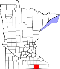
Location in the state of Minnesota
Minnesota's location in the U.S.Founded February 20, 1855 [1] Named for John Edward Mower, a lumber worker and state legislator. Seat Austin Largest city Austin Area
- Total
- Land
- Water
711.71 sq mi (1,843 km²)
711.50 sq mi (1,843 km²)
0.21 sq mi (1 km²), 0.03%Population
- (2010)
- Density
39,163
54/sq mi (21/km²)Time zone Central: UTC-6/-5 Website www.co.mower.mn.us Mower County (named for John Edward Mower) is a county located in the U.S. state of Minnesota. The county seat is Austin. As of 2010, the population was 39,163.[1] Lake Louise State Park is located in the southeast part of the county near Le Roy.
Contents
Settlement and History
In 1852 Jacob McQuillin and his family settled what was to become Mower County. By 1855 the area had enough people to merit official formation and on March 1, 1856 Minnesota Governor Willis A. Gorman (D) signed the act organizing Mower County. The county was named in honor of John Edward Mower, a member of the territorial legislature.
Geography
According to the 2000 census, the county has a total area of 711.71 square miles (1,843.3 km2), of which 711.50 square miles (1,842.8 km2) (or 99.97%) is land and 0.21 square miles (0.54 km2) (or 0.03%) is water.[2]
Lakes
Although Mower County is one of only four counties in Minnesota with no natural lake, it does have four small ponds and lakes created by dams.
- East Side Lake: in the northeast quadrant of Austin
- Lake Louise: in Lake Louise State Park near Le Roy
- Mill Pond: in downtown Austin near the Hormel plant
- Ramsey Mill Pond: in Ramsey Golf Course, near the unincorporated settlement of Ramsey
The Cedar River (sometimes called the Red Cedar River) flows south into the county from its source in Dodge County and continues all the way through the county into Mitchell County, Iowa. It flows through Mower County's four westernmost townships: Udolpho, Lansing, Austin, and Lyle.
Major highways
 Interstate 90
 U.S. Highway 63
 U.S. Highway 218
 Minnesota State Highway 16
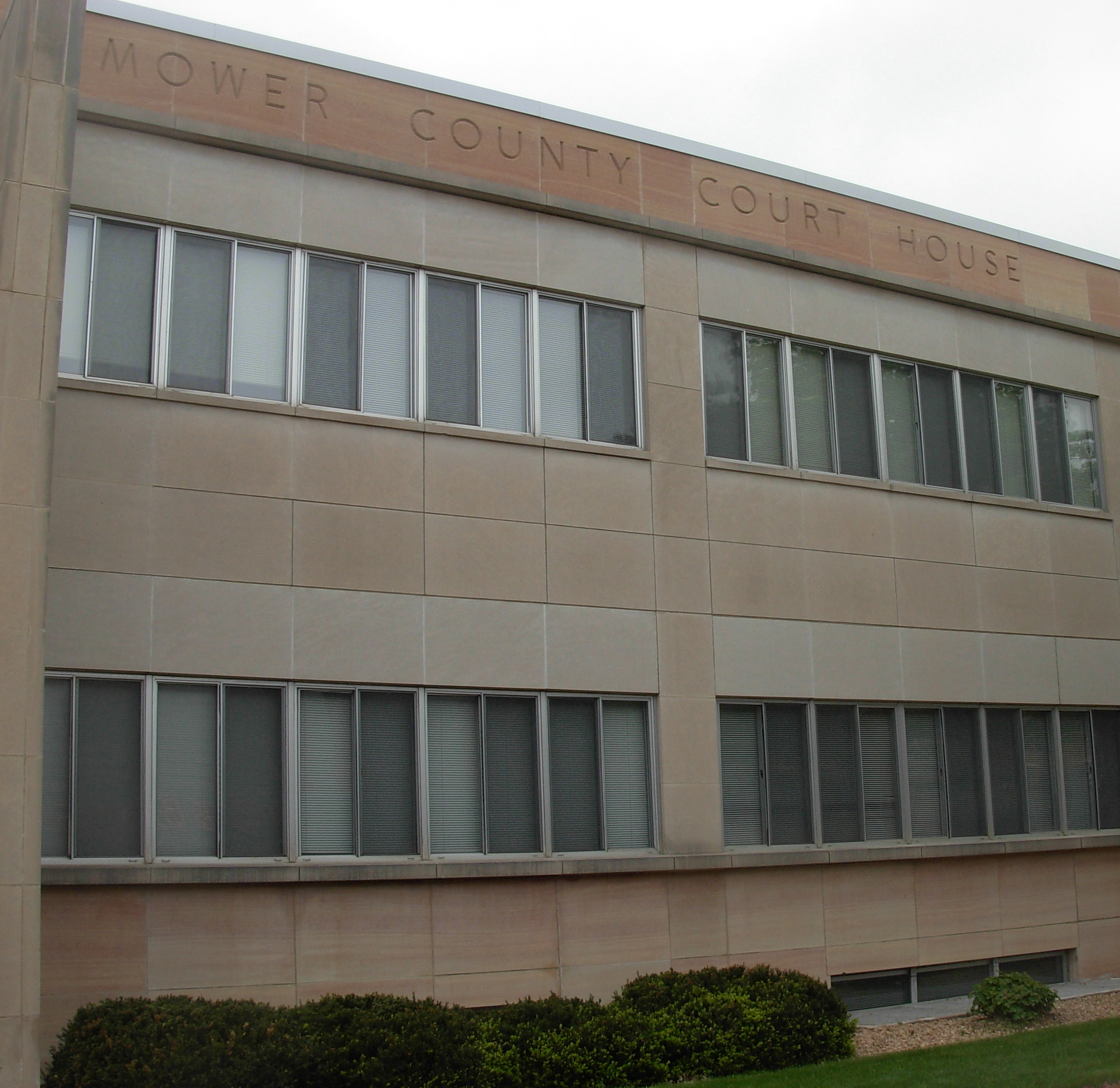
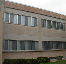 Mower County Courthouse in Austin, Minnesota.
Adjacent counties
- Dodge County (north)
- Olmsted County (northeast)
- Fillmore County (east)
- Howard County, Iowa (southeast)
- Mitchell County, Iowa (south)
- Worth County, Iowa (southwest)
- Freeborn County (west)
Demographics
Historical populations Census Pop. %± 1860 3,217 — 1870 10,447 224.7% 1880 16,799 60.8% 1890 18,019 7.3% 1900 22,335 24.0% 1910 22,640 1.4% 1920 25,993 14.8% 1930 28,065 8.0% 1940 36,113 28.7% 1950 42,277 17.1% 1960 48,498 14.7% 1970 44,919 −7.4% 1980 40,390 −10.1% 1990 37,385 −7.4% 2000 38,603 3.3% 2010 39,163 1.5% U.S. Decennial Census 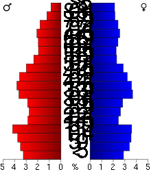 Age pyramid of county residents based on 2000 U.S. census data.
As of the census[3] of 2000, there were 38,603 people, 15,582 households, and 10,315 families residing in the county. The population density was 54 people per square mile (21/km²). There were 16,251 housing units at an average density of 23 per square mile (9/km²). The racial makeup of the county was 94.7% White, 0.6% Black or African American, 0.2% Native American, 1.5% Asian, <0.1% Pacific Islander, 2.2% from other races, and 0.9% from two or more races. 4.3% of the population were Hispanic or Latino of any race. 35.9% were of German, 24.4% Norwegian and 7.0% Irish ancestry according to Census 2000.
There were 15,582 households out of which 29.70% had children under the age of 18 living with them, 54.70% were married couples living together, 8.00% had a female householder with no husband present, and 33.80% were non-families. 29.10% of all households were made up of individuals and 14.80% had someone living alone who was 65 years of age or older. The average household size was 2.42 and the average family size was 2.98.
In the county the population was spread out with 25.1% under the age of 18, 8.2% from 18 to 24, 25.7% from 25 to 44, 21.4% from 45 to 64, and 19.6% who were 65 years of age or older. The median age was 39 years. For every 100 females there were 97.00 males. For every 100 females age 18 and over, there were 93.60 males.
The median income for a household in the county was $36,654, and the median income for a family was $45,154. Males had a median income of $31,743 versus $23,317 for females. The per capita income for the county was $19,795. About 6.3% of families and 9.2% of the population were below the poverty line, including 11.3% of those under age 18 and 5.6% of those age 65 or over.
Communities
Cities
Adams, Austin (the county seat), Brownsdale, Dexter, Elkton, Grand Meadow, Le Roy, Lyle, Mapleview, Racine, Rose Creek, Sargeant, Taopi, Waltham
In order of population size (2000 census): Austin (23,314), Grand Meadow (945), Le Roy (925), Adams (800), Brownsdale (718), Lyle (566), Racine (355), Rose Creek (354), Dexter (333), Waltham (196), Mapleview (189), Elkton (149), Taopi (93), Sargeant (76).
Townships
All of Mower County's land is divided into 20 townships that are 36 square miles (six miles north to south X six miles (10 km) west to east) in area. Mower County is five townships wide (a total of 30 miles (48 km) west to east) and four townships from north to south (a total of 24 miles). The arrangement of the townships within the county is shown below (Udolpho Township is in the northwest corner and Le Roy Township is in the southeast).
Location of townships in Mower County 1 2 3 4 5 1 Udolpho Waltham Sargeant Pleasant Valley Racine 2 Lansing Red Rock Dexter Grand Meadow Frankford 3 Austin Windom Marshall Clayton Bennington 4 Lyle Nevada Adams Lodi Le Roy Administration
Five people are elected as Mower County Commissioners, serving staggered four year terms. Commissioners work to provide services to people and communities while overseeing the cost of such services. The Mower County Board meets the first, second, and fourth Tuesday each month in the Board Room located in the Lower Level of the Mower County Courthouse. The first meeting of the month begins at 1:00 PM while the remaining begin with departmental business at 8:30 AM with general business starting around 10:00 AM.
- First District- Cities: Brownsdale, Mapleview, Waltham and the 1st Ward, 1st Precinct of Austin
- Townships: Lansing Township, Red Rock Township, Udolpho Township, Waltham Township
- Commissioner: Tim Gabrielson
- Townships: Lansing Township, Red Rock Township, Udolpho Township, Waltham Township
- Second District- Cities: Adams, Dexter, Elkton, Grand Meadow, Le Roy, Racine, Sargeant, Taopi
- Townships: Adams Township, Bennington Township, Clayton Township, Dexter Township, Frankford Township, Grand Meadow Township, Le Roy Township, Lodi Township, Marshall Township, Pleasant Valley Township, Racine Township, Sargeant Township
- Commissioner:Raymond Tucker
- Townships: Adams Township, Bennington Township, Clayton Township, Dexter Township, Frankford Township, Grand Meadow Township, Le Roy Township, Lodi Township, Marshall Township, Pleasant Valley Township, Racine Township, Sargeant Township
- Third District- Cities: Lyle, Rose Creek and the 2nd Ward, 2nd Precinct of the City of Austin.
- Townships: Austin, Lyle, Nevada and Windom.
- Commissioner: Jerry Reinartz
- Townships: Austin, Lyle, Nevada and Windom.
- Fourth District - The 4th District includes all of the 3rd ward of the city of Austin.
- Commissioner:Tony Bennett
- Fifth District - The 5th District includes the 1st Ward, 2nd Precinct and the 2nd Ward 1st Princt of the City of Austin.
- Commissioner: Mike Ankeny
See also
References
- ^ "2010 Census Redistricting Data (Public Law 94-171) Summary File". American FactFinder. United States Census Bureau. http://factfinder2.census.gov/faces/tableservices/jsf/pages/productview.xhtml?pid=DEC_10_PL_GCTPL2.ST05&prodType=table. Retrieved 25 April 2011.
- ^ "Census 2000 U.S. Gazetteer Files: Counties". United States Census. http://www.census.gov/tiger/tms/gazetteer/county2k.txt. Retrieved 2011-02-13.
- ^ "American FactFinder". United States Census Bureau. http://factfinder.census.gov. Retrieved 2008-01-31.
External links

Dodge County Olmsted County Freeborn County 
Fillmore County  Mower County, Minnesota

Worth County, Iowa Mitchell County, Iowa Howard County, Iowa Municipalities and communities of Mower County, Minnesota Cities Adams | Austin | Brownsdale | Dexter | Elkton | Grand Meadow | Le Roy | Lyle | Mapleview | Racine | Rose Creek | Sargeant | Taopi | Waltham

Townships Categories:- Minnesota counties
- Mower County, Minnesota


Wikimedia Foundation. 2010.