- Minnesota Territory
-
Territory of Minnesota Organized incorporated territory of the United States ← 
←
1849–1858  →
→
 →
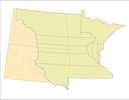
→Capital St. Paul Government Organized incorporated territory Governor - 1849-1853 Alexander Ramsey - 1853-1857 Willis A. Gorman - 1857-1858 Samuel Medary History - Split from Iowa Territory March 3 1849 - Statehood May 11 1858  Nine original Minnesota Territory Counties (1849-1851) superimposed over Minnesota, North Dakota and South Dakota of today
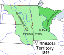
The Territory of Minnesota was an organized incorporated territory of the United States that existed from March 3, 1849, until May 11, 1858, when the eastern portion of the territory was admitted to the Union as the State of Minnesota.
Contents
History
Further information: Territorial era of MinnesotaThe boundaries of the Minnesota Territory, as carved out of Iowa Territory, included the current Minnesota region and most of what later became Dakota Territory east of the Missouri River. Minnesota Territory also included portions of Wisconsin Territory that did not become part of Wisconsin, located between the Mississippi River and Wisconsin, including the Arrowhead Region.[1]
At the time of its formation, the territory contained three cities: St. Paul, St. Anthony (now part of Minneapolis), and Stillwater. The major territorial institutions were divided among the three: St. Paul was made the capital; Minneapolis was selected as the site of the University of Minnesota; and Stillwater was chosen as the site of the Minnesota Territorial Prison.[2]
Territorial Governors
# Governor Took office Left office Party 1 Alexander Ramsey 
June 1, 1849 May 15, 1853 Whig 2 Willis Arnold Gorman 
May 15, 1853 April 23, 1857 Democratic 3 Samuel Medary 
April 23, 1857 May 24, 1858 Democratic Territorial Secretaries
- Charles K. Smith, 1849–1851
- Alexander Wilkin, 1851–1853
- Joseph Rosser. 1853-1857
- Charles L. Chase 1857-1858
Congressional Delegates
- Henry Hastings Sibley, 31st Congress, 32nd Congress, 1849–1853
- Henry Mower Rice, 33rd Congress, 34th Congress, 1853–1857
- William W. Kingsbury, 35th Congress, 1857–1858
See also
- John Catlin
- Historic regions of the United States
- History of Minnesota
- Interior Plains
- Territorial era of Minnesota
- Territorial evolution of the United States
- Territory of France that encompassed land that would later become part of the Territory of Minnesota:
- Louisiane, 1682–1764 and 1803
- Territory of Spain that would later be returned to France:
- Luisiana, 1764–1803
- Territory of the United Kingdom that encompassed land that would later become part of the Territory of Minnesota:
- Rupert's Land, 1670–1870
- U.S. territories that encompassed land that would later become part of the Territory of Minnesota:
- Territory Northwest of the River Ohio, 1787–1803
- Territory of Indiana, 1800–1816
- Louisiana Purchase, 1803–1804
- District of Louisiana, 1804–1805
- Territory of Louisiana, 1805–1812
- Territory of Illinois, 1809–1818
- Territory of Missouri, 1812–1821
- Territory of Michigan, 1805–1837
- Territory of Wisconsin, 1836–1848
- U.S. territories that encompassed land that was previously part of the Territory of Minnesota:
- Territory of Dakota, 1861–1889
- U.S. states that encompass land that was once part of the Territory of Minnesota:
- State of Minnesota, 1858
- State of North Dakota, 1889
- State of South Dakota, 1889
- Territory of France that encompassed land that would later become part of the Territory of Minnesota:
References
- ^ See The Student Page of the Minnesota Secretary of State for an overview of how Minnesota's state boundaries were determined.
- ^ Minnesota History at the Minnesota State University, Mankato website, retrieved 4 July 2007.
External links
Categories:- States and territories established in 1849
- States and territories disestablished in 1858
- Minnesota Territory
- North Dakota geography stubs
- United States history stubs
Wikimedia Foundation. 2010.


