- Rice County, Minnesota
-
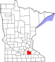
Rice County, Minnesota 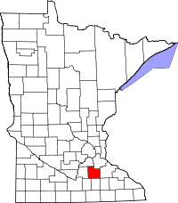
Location in the state of Minnesota
Minnesota's location in the U.S.Founded March 5, 1853 [1] Named for Henry Mower Rice,[1] one of the first two U.S. senators from Minnesota. Seat Faribault Largest city Faribault Area
- Total
- Land
- Water
516.13 sq mi (1,337 km²)
497.57 sq mi (1,289 km²)
18.56 sq mi (48 km²), 3.60%Population
- (2010)
- Density
64,142
114/sq mi (44/km²)Time zone Central: UTC-6/-5 Website www.co.rice.mn.us Rice County is a county located in the U.S. state of Minnesota. As of 2010, the population was 64,142.[2] Its county seat is Faribault[3].
Contents
Geography
According to the 2000 census, the county has a total area of 516.13 square miles (1,336.8 km2), of which 497.57 square miles (1,288.7 km2) (or 96.40%) is land and 18.56 square miles (48.1 km2) (or 3.60%) is water.[4] The Cannon River flows northeastwardly through the county, collecting the Straight River in Faribault. The North Fork of the Zumbro River has its headwaters in the southeastern part of the county.[5]
Lakes
 Henry Mower Rice, one of Minnesota's first senators and the namesake of the county
- Cannon Lake: almost entirely in Warsaw Township, but the far western part extends into Morristown Township
- Caron Lake: in Shieldsville Township
- Cedar Lake: in Shieldsville Township
- Circle Lake: in Forest Township
- Crystal Lake: in Cannon City Township
- Duban Lake: in Erin Township
- Dudley Lake: in Wells Township
- Fox Lake: in Forest Township
- French Lake: mostly in Wells Township, but the western part extends into Shieldsville Township
- Hatch Lake: in Wheatland Township
- Horseshoe Lake: eastern third is in Morristown Township; the rest is in Le Sueur County
- Hunt Lake: in Shieldsville Township
- Kelly Lake: in Wells Township
- Mazaska Lake: in four different townships: Wells, Shieldsville, Forest, and Erin
- Metogga Lake: in Wheatland Township
- Mud Lake: in Shieldsville Township
- Phelps Lake: all of the northern Phelps Lake is in Wheatland Township; the northern third of the southern Phelps Lake is in Wheatland Township and the rest is in Erin Township
- Rice Lake: in Shieldsville Township
- Roberds Lake: in Wells Township
- Sakatah Lake: eastern half is in Morristown Township; western half is in Le Sueur County
- Shields Lake: northern half is in Erin Township and the southern half is in Shieldsville Township
- Sprague Lake: in Morristown Township
- Union Lake: souther half is in Forest Township; northern half is in Webster Township
- Weinberger Lake: in Morristown Township
- Wells Lake: mostly in Wells Township, but the southern part extends into Warsaw Township
- Willing Lake: in Shieldsville Township
Major highways
Adjacent counties
- Dakota County (northeast)
- Goodhue County (east)
- Dodge County (southeast)
- Steele County (south)
- Waseca County (southwest)
- Le Sueur County (west)
- Scott County (northwest)
Demographics
Historical populations Census Pop. %± 1860 7,543 — 1870 16,083 113.2% 1880 22,481 39.8% 1890 23,968 6.6% 1900 26,080 8.8% 1910 25,911 −0.6% 1920 28,307 9.2% 1930 29,974 5.9% 1940 32,160 7.3% 1950 36,235 12.7% 1960 38,988 7.6% 1970 41,582 6.7% 1980 46,087 10.8% 1990 49,183 6.7% 2000 56,665 15.2% 2010 64,142 13.2% U.S. Decennial Census 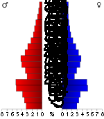 Age pyramid of county residents based on 2000 U.S. census data.
As of the census[6] of 2000, there were 56,665 people, 18,888 households, and 13,353 families residing in the county. The population density was 114 people per square mile (44/km²). There were 20,061 housing units at an average density of 40 per square mile (16/km²). The racial makeup of the county was 93.59% White, 1.31% Black or African American, 0.43% Native American, 1.46% Asian, 0.04% Pacific Islander, 1.87% from other races, and 1.30% from two or more races. 5.50% of the population were Hispanic or Latino of any race. 32.1% were of German, 14.7% Norwegian, 7.2% Irish and 5.3% Czech ancestry according to Census 2000.
There were 18,888 households out of which 36.50% had children under the age of 18 living with them, 58.10% were married couples living together, 8.60% had a female householder with no husband present, and 29.30% were non-families. 23.90% of all households were made up of individuals and 9.10% had someone living alone who was 65 years of age or older. The average household size was 2.65 and the average family size was 3.14.
In the county the population was spread out with 25.30% under the age of 18, 15.80% from 18 to 24, 27.40% from 25 to 44, 20.20% from 45 to 64, and 11.40% who were 65 years of age or older. The median age was 33 years. For every 100 females there were 101.80 males. For every 100 females age 18 and over, there were 100.30 males.
The median income for a household in the county was $48,651, and the median income for a family was $56,407. Males had a median income of $36,771 versus $26,151 for females. The per capita income for the county was $19,695. About 4.00% of families and 6.90% of the population were below the poverty line, including 5.70% of those under age 18 and 10.70% of those age 65 or over.
Cities and towns
Large Cities Towns Townships Unincorporated - Cannon City
- Little Chicago
- Millersburg
- Moland†
- Prarieville
- Ruskin
- Warsaw
- Webster
- Veseli
† Dennison is in Goodhue County, but a small part extends into Rice County.
Moland is considered to be mostly in Steele County, but the area also extends into Rice County. ‡ A part of Northfield extends into Dakota County.See also
County Parks
- Ackman Park 3 miles (4.8 km) west of Faribault
- Albers Park in Webster
- Cannon River Wilderness Area 4 miles (6.4 km) north of Faribault
- Caron Park in Cannon City
- Falls Creek Park 1-mile (1.6 km) east of Faribault
- Heron Island in Shieldsville
- Hirdler Park 10 miles (16 km) west of Faribault
- Kalina Park in Wheatland
- King Mill Park in Faribault
- Shager Park 2 miles (3.2 km) west of Faribault
References
- ^ Fedo, Michael (2002). Pocket Guide to Minnesota Place Names. Canada: Minnesota Historical Society Press. pp. 127. ISBN 0-87351-424-6. http://shop.mnhs.org/moreinfomhspress.cfm?Product_ID=139.
- ^ "2010 Census Redistricting Data (Public Law 94-171) Summary File". American FactFinder. United States Census Bureau. http://factfinder2.census.gov/faces/tableservices/jsf/pages/productview.xhtml?pid=DEC_10_PL_GCTPL2.ST05&prodType=table. Retrieved 25 April 2011.
- ^ "Find a County". National Association of Counties. http://www.naco.org/Counties/Pages/FindACounty.aspx. Retrieved 2011-06-07.
- ^ "Census 2000 U.S. Gazetteer Files: Counties". United States Census. http://www.census.gov/tiger/tms/gazetteer/county2k.txt. Retrieved 2011-02-13.
- ^ Minnesota Atlas & Gazetteer. Yarmouth, Me.: DeLorme. 1994. pp. 33. ISBN 0-89933-222-6.
- ^ "American FactFinder". United States Census Bureau. http://factfinder.census.gov. Retrieved 2008-01-31.
External links

Scott County Dakota County Le Sueur County 
Goodhue County  Rice County, Minnesota

Waseca County Steele County Dodge County Municipalities and communities of Rice County, Minnesota Cities Dennison‡ | Dundas | Faribault | Lonsdale | Morristown | Nerstrand | Northfield‡
Townships Bridgewater | Cannon City | Erin | Forest | Morristown | Northfield | Richland | Shieldsville | Walcott | Warsaw | Webster | Wells | Wheatland | Wheeling
Unincorporated
communitiesCannon City | Little Chicago | Moland‡ | Ruskin | Warsaw
Footnotes ‡This populated place also has portions in an adjacent county or counties
Categories:- Minnesota counties
- Rice County, Minnesota


Wikimedia Foundation. 2010.